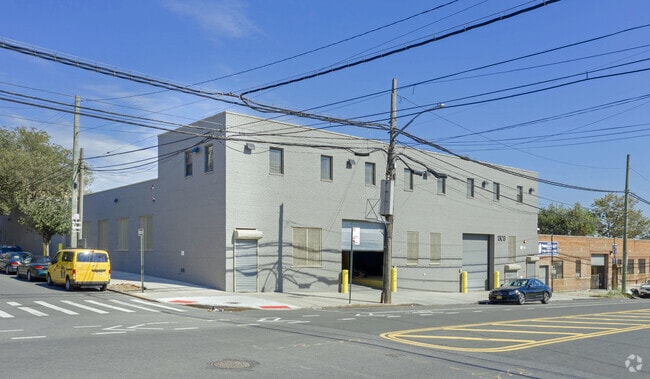
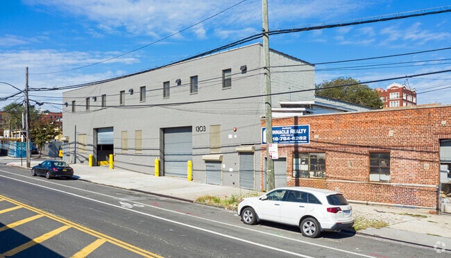
Property Record
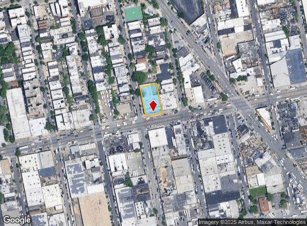
1303 Randall Ave, Bronx, NY 10474

NEARBY LISTINGS FOR SALE OR LEASE
Property Detail
1303 Randall Ave
02766-0098
Bronx
Warehouse
New York
X
98
3604970084F
0.40 AC
2024
Bronx
2025
Westchester/So Connecticut
009301
New York-Jersey City-White Plains, NY-NJ
20,000 SF
DEMOGRAPHICS near 1303 Randall Ave
1 Mile
3 Mile
5 Mile
2024 Total Population
59,821
838,459
2,598,928
2029 Population
55,719
777,269
2,410,587
Pop Growth 2024-2029
(6.86%)
(7.30%)
(7.25%)
Average Age
37
37
39
2024 Total Households
20,417
297,739
986,341
HH Growth 2024-2029
(7.71%)
(7.96%)
(7.68%)
Median Household Inc
$35,609
$38,349
$54,125
Avg Household Size
2.70
2.70
2.50
2024 Avg HH Vehicles
.00
.00
.00
Median Home Value
$430,078
$563,383
$698,297
Median Year Built
1960
1956
1952
Nearby Places
Map Layers
Map Styles
 Street
 Aerial
- Restaurants
- Banks
- Shops
- Fitness
- Groceries
PUBLIC TRANSPORTATION
TRANSIT/SUBWAY
Hunts Point Avenue (6 - New York MTA Subway (The Subway))
DRIVE
WALK
Distance
Hunts Point Avenue (6 - New York MTA Subway (The Subway))
2 min
13 min
0.7 mi
Longwood Avenue (6 - New York MTA Subway (The Subway))
DRIVE
WALK
Distance
Longwood Avenue (6 - New York MTA Subway (The Subway))
1 min
14 min
0.7 mi
Simpson Street (2 - New York MTA Subway (The Subway), 5 - New York MTA Subway (The Subway))
DRIVE
WALK
Distance
Simpson Street (2 - New York MTA Subway (The Subway), 5 - New York MTA Subway (The Subway))
3 min
19 min
1.0 mi
East 149 Street (6 - New York MTA Subway (The Subway))
DRIVE
WALK
Distance
East 149 Street (6 - New York MTA Subway (The Subway))
2 min
20 min
1.0 mi
Intervale Avenue (2 - New York MTA Subway (The Subway), 5 - New York MTA Subway (The Subway))
DRIVE
WALK
Distance
Intervale Avenue (2 - New York MTA Subway (The Subway), 5 - New York MTA Subway (The Subway))
3 min
20 min
1.1 mi
COMMUTER RAIL
Melrose Station (Harlem Line - Metro-North Commuter Railroad Company (Metro-North))
DRIVE
WALK
Distance
Melrose Station (Harlem Line - Metro-North Commuter Railroad Company (Metro-North))
7 min
2.4 mi
Tremont Station (Harlem Line - Metro-North Commuter Railroad Company (Metro-North))
DRIVE
WALK
Distance
Tremont Station (Harlem Line - Metro-North Commuter Railroad Company (Metro-North))
8 min
3.8 mi
AIRPORT
LaGuardia
DRIVE
WALK
Distance
LaGuardia
14 min
7.2 mi
John F Kennedy International
DRIVE
WALK
Distance
John F Kennedy International
27 min
18.5 mi
Newark Liberty International
DRIVE
WALK
Distance
Newark Liberty International
32 min
25.6 mi
Freight Ports
NY - Red Hook Container Terminal
DRIVE
WALK
Distance
NY - Red Hook Container Terminal
27 min
15.4 mi
SALE & LEASE HISTORY
LISTING DATE
SALE/LEASE

Mar 16, 2020
For Sale
Mar 16, 2020
For Lease
Apr 11, 2022
For Sale
Nearby Properties
Address
Land Use
TOTAL SIZE
Lot Size
Zoning
Address
Land Use
TOTAL SIZE
Lot Size
Zoning
5,519,372 SF
409.21 AC
C8-2
Address
Land Use
TOTAL SIZE
Lot Size
Zoning
2,278,432 SF
5.99 AC
R7-2
Address
Land Use
TOTAL SIZE
Lot Size
Zoning
1,311,800 SF
9.89 AC
C4-4
Address
Land Use
TOTAL SIZE
Lot Size
Zoning
207.09 AC
PARK
Address
Land Use
TOTAL SIZE
Lot Size
Zoning
1,012,000 SF
7.79 AC
R6
Address
Land Use
TOTAL SIZE
Lot Size
Zoning
507,265 SF
4.04 AC
C4-4
Address
Land Use
TOTAL SIZE
Lot Size
Zoning
892,550 SF
2.93 AC
M13R8
Address
Land Use
TOTAL SIZE
Lot Size
Zoning
2,531,670 SF
17.15 AC
R7-2
Address
Land Use
TOTAL SIZE
Lot Size
Zoning
390,750 SF
265 AC
PARK
Address
Land Use
TOTAL SIZE
Lot Size
Zoning
480,769 SF
1.21 AC
R8
Address
Land Use
TOTAL SIZE
Lot Size
Zoning
276,285 SF
1.26 AC
R7-2
Address
Land Use
TOTAL SIZE
Lot Size
Zoning
293,848 SF
2.98 AC
C8-3
Address
Land Use
TOTAL SIZE
Lot Size
Zoning
426,172 SF
14.30 AC
M3-1
Address
Land Use
TOTAL SIZE
Lot Size
Zoning
491,007 SF
11.85 AC
M3-1
Address
Land Use
TOTAL SIZE
Lot Size
Zoning
566,233 SF
13.25 AC
M3-1
Address
Land Use
TOTAL SIZE
Lot Size
Zoning
291,885 SF
8.86 AC
R8
Address
Land Use
TOTAL SIZE
Lot Size
Zoning
139,333 SF
1.17 AC
C6-3
Address
Land Use
TOTAL SIZE
Lot Size
Zoning
14,681 SF
97 AC
PARK
Address
Land Use
TOTAL SIZE
Lot Size
Zoning
127,000 SF
16.53 AC
M3-1
Address
Land Use
TOTAL SIZE
Lot Size
Zoning
447,145 SF
8.05 AC
M3-1
Address
Land Use
TOTAL SIZE
Lot Size
Zoning
489,326 SF
19.18 AC
C8-1
Address
Land Use
TOTAL SIZE
Lot Size
Zoning
245,002 SF
9.12 AC
C8-3
Address
Land Use
TOTAL SIZE
Lot Size
Zoning
238,500 SF
1.13 AC
C4-4
Address
Land Use
TOTAL SIZE
Lot Size
Zoning
340,364 SF
4.10 AC
C4-6
Address
Land Use
TOTAL SIZE
Lot Size
Zoning
429,149 SF
4.79 AC
C4-4
Address
Land Use
TOTAL SIZE
Lot Size
Zoning
1,172,005 SF
128.83 AC
M1-1
Address
Land Use
TOTAL SIZE
Lot Size
Zoning
594,976 SF
1.62 AC
C4-6
Address
Land Use
TOTAL SIZE
Lot Size
Zoning
464,489 SF
5.66 AC
C4-4
Address
Land Use
TOTAL SIZE
Lot Size
Zoning
1,478,410 SF
8.84 AC
R6
Address
Land Use
TOTAL SIZE
Lot Size
Zoning
420,416 SF
1.54 AC
M13R8
The World's #1 Commercial Real Estate Marketplace
Connect with us
© 2025 CoStar Group
The information above has been obtained from sources believed reliable. While we do not doubt its accuracy we have not verified it and make no guarantee, warranty or representation about it. It is your responsibility to independently confirm its accuracy and completeness. Any projections, opinions, assumptions, or estimates used are for example only and do not represent the current or future performance of the property. The value of this transaction to you depends on tax and other factors which should be evaluated by your tax, financial, and legal advisors. You and your advisors should conduct a careful, independent investigation of the property to determine to your satisfaction the suitability of the property for your needs.