Property Record
4535 N Kedzie Ave N, Chicago, IL 60625


Save to a Folder
{{folder.Name}}
{{folder.ListingIds.length}} Properties
{{folder.ListingIds.length}} Property
Create a New Folder
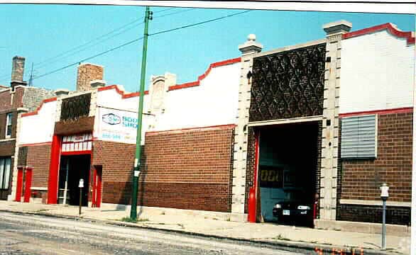
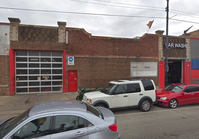
Property Detail
4535 N Kedzie Ave N
13-13-117-004-0000
(NORTHWESTERN)(LAND)(ASSOCIATION) SUB OF EX RW OF NOR THWESTERN ELEV. R.R. WH NW SEC 13-40-13
Parkingstructure
Cook
C2-2
Illinois
B and X Area of moderate flood hazard, usually the area between the limits of the 100-year and 500-year floods.
5
2023
0.29 AC
2025
Northwest City
140800
Chicago
12,456 SF
Chicago-Naperville-Elgin, IL-IN
NEARBY LISTINGS FOR SALE OR LEASE
DEMOGRAPHICS near 4535 N Kedzie Ave N
1 mile
3 mile
5 mile
2025 Total Population
66,345
470,428
1,096,948
2030 Population
64,892
463,702
1,082,609
Pop Growth 2025-2030
(2.19%)
(1.43%)
(1.31%)
Average Age
38
38
38
2025 Total Households
25,283
198,373
468,750
HH Growth 2025-2030
(2.61%)
(1.55%)
(1.26%)
Median Household Inc
$89,380
$89,201
$89,269
Avg Household Size
2.50
2.30
2.20
2025 Avg HH Vehicles
1.00
1.00
1.00
Median Home Value
$422,001
$442,364
$416,138
Median Year Built
1946
1947
1948
Nearby Places
Map Layers
Map Styles
 Street
 Aerial
Layers
 Traffic
 Biking
Places
Listings with unknown addresses are not visible on the map
- Restaurants
- Banks
- Shops
- Fitness
- Groceries
PUBLIC TRANSPORTATION
TRANSIT/SUBWAY
Kedzie Station (Brown Line) (Brown Line - Chicago Transit Authority "L" Trains (The "L"))
Drive
Walk
Distance
Kedzie Station (Brown Line) (Brown Line - Chicago Transit Authority "L" Trains (The "L"))
0 min
3 min
0.1 mi
Francisco Station (Brown Line - Chicago Transit Authority "L" Trains (The "L"))
Drive
Walk
Distance
Francisco Station (Brown Line - Chicago Transit Authority "L" Trains (The "L"))
2 min
9 min
0.4 mi
Kimball Station (Brown Line - Chicago Transit Authority "L" Trains (The "L"))
Drive
Walk
Distance
Kimball Station (Brown Line - Chicago Transit Authority "L" Trains (The "L"))
1 min
10 min
0.5 mi
Rockwell Station (Brown Line - Chicago Transit Authority "L" Trains (The "L"))
Drive
Walk
Distance
Rockwell Station (Brown Line - Chicago Transit Authority "L" Trains (The "L"))
3 min
18 min
0.9 mi
COMMUTER RAIL
Ravenswood Station (Union Pacific North Line - Northeast Illinois Regional Commuter Railroad (Metra))
Drive
Walk
Distance
Ravenswood Station (Union Pacific North Line - Northeast Illinois Regional Commuter Railroad (Metra))
5 min
2.3 mi
Mayfair Station (Milwaukee District North Line - Northeast Illinois Regional Commuter Railroad (Metra))
Drive
Walk
Distance
Mayfair Station (Milwaukee District North Line - Northeast Illinois Regional Commuter Railroad (Metra))
5 min
2.4 mi
AIRPORT
Chicago O'Hare International
Drive
Walk
Distance
Chicago O'Hare International
19 min
11.1 mi
Chicago Midway International
Drive
Walk
Distance
Chicago Midway International
26 min
13.8 mi
SALE & LEASE HISTORY
LISTING DATE
SALE/LEASE

Oct 07, 2020
For Sale
Jun 19, 2019
For Sale
Nearby Properties
Address
Land Use
TOTAL SIZE
Lot Size
Zoning
Address
Land Use
TOTAL SIZE
Lot Size
Zoning
Address
Land Use
TOTAL SIZE
Lot Size
Zoning
Address
Land Use
TOTAL SIZE
Lot Size
Zoning
0.96 AC
PD 958
Address
Land Use
TOTAL SIZE
Lot Size
Zoning
16.93 AC
POS-1,PD 1
Address
Land Use
TOTAL SIZE
Lot Size
Zoning
19,500 SF
12.06 AC
PD 367
Address
Land Use
TOTAL SIZE
Lot Size
Zoning
277,195 SF
1.78 AC
PD 1094
Address
Land Use
TOTAL SIZE
Lot Size
Zoning
0.94 AC
PD 536
Address
Land Use
TOTAL SIZE
Lot Size
Zoning
1 AC
RS-3
Address
Land Use
TOTAL SIZE
Lot Size
Zoning
Address
Land Use
TOTAL SIZE
Lot Size
Zoning
PD 184
Address
Land Use
TOTAL SIZE
Lot Size
Zoning
237,832 SF
14.04 AC
PD 418
Address
Land Use
TOTAL SIZE
Lot Size
Zoning
190,011 SF
5.90 AC
PD 353
Address
Land Use
TOTAL SIZE
Lot Size
Zoning
170,538 SF
0.76 AC
PD 112
Address
Land Use
TOTAL SIZE
Lot Size
Zoning
331,294 SF
13.03 AC
PD 439
Address
Land Use
TOTAL SIZE
Lot Size
Zoning
71,400 SF
0.95 AC
RT-4,B3-2
Address
Land Use
TOTAL SIZE
Lot Size
Zoning
201,600 SF
1.93 AC
PD 92
Address
Land Use
TOTAL SIZE
Lot Size
Zoning
2.25 AC
PD 612
Address
Land Use
TOTAL SIZE
Lot Size
Zoning
139.71 AC
PD 184
Address
Land Use
TOTAL SIZE
Lot Size
Zoning
0.69 AC
PD 536
Address
Land Use
TOTAL SIZE
Lot Size
Zoning
140,451 SF
9.48 AC
PD 213
Address
Land Use
TOTAL SIZE
Lot Size
Zoning
63,700 SF
7.42 AC
PD 796
Address
Land Use
TOTAL SIZE
Lot Size
Zoning
17,594 SF
0.11 AC
B2-5
Address
Land Use
TOTAL SIZE
Lot Size
Zoning
382,635 SF
5.90 AC
M1-1
Address
Land Use
TOTAL SIZE
Lot Size
Zoning
15,600 SF
0.77 AC
M1-1
Address
Land Use
TOTAL SIZE
Lot Size
Zoning
226,345 SF
3.71 AC
PD 1203
Address
Land Use
TOTAL SIZE
Lot Size
Zoning
100,900 SF
4.85 AC
PD 1415
Address
Land Use
TOTAL SIZE
Lot Size
Zoning
144,865 SF
0.21 AC
Address
Land Use
TOTAL SIZE
Lot Size
Zoning
340,838 SF
31 AC
PD 1411
Address
Land Use
TOTAL SIZE
Lot Size
Zoning
0.57 AC
PD 536
Address
Land Use
TOTAL SIZE
Lot Size
Zoning
197,785 SF
4.03 AC
PD 943
The World's #1 Commercial Real Estate Marketplace
Connect with us
© 2026 CoStar Group
The information above has been obtained from sources believed reliable. While we do not doubt its accuracy we have not verified it and make no guarantee, warranty or representation about it. It is your responsibility to independently confirm its accuracy and completeness. Any projections, opinions, assumptions, or estimates used are for example only and do not represent the current or future performance of the property. The value of this transaction to you depends on tax and other factors which should be evaluated by your tax, financial, and legal advisors. You and your advisors should conduct a careful, independent investigation of the property to determine to your satisfaction the suitability of the property for your needs.