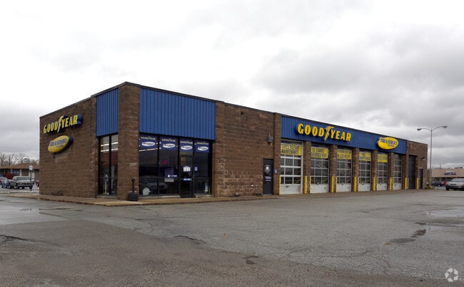
Property Record
1303 S High School Rd, Indianapolis, IN 46241


NEARBY LISTINGS FOR SALE OR LEASE
Property Detail
1303 S High School Rd
49-12-13-104-024.000-930
PT NW1/4 S13 T15 R2 BEG 732 S & 257.1 E OF NWCOR; E148.89, S144.95, W152.74, N144.99 TOBEG .502AC.
Autorepair
Marion
X
Indiana
18097C0207F
0.50 AC
2023
Speedway
2024
Indianapolis
342101
Indianapolis-Carmel-Anderson, IN
5,200 SF
DEMOGRAPHICS near 1303 S High School Rd
1 Mile
3 Mile
5 Mile
2024 Total Population
8,449
58,859
176,617
2029 Population
8,232
57,876
176,999
Pop Growth 2024-2029
(2.57%)
(1.67%)
+ 0.22%
Average Age
35
37
36
2024 Total Households
3,105
22,665
67,234
HH Growth 2024-2029
(2.64%)
(1.71%)
+ 0.20%
Median Household Inc
$45,554
$50,291
$53,698
Avg Household Size
2.60
2.50
2.50
2024 Avg HH Vehicles
2.00
2.00
2.00
Median Home Value
$139,555
$135,218
$141,299
Median Year Built
1968
1968
1972
Nearby Places
Map Layers
Map Styles
 Street
 Aerial
- Restaurants
- Banks
- Shops
- Fitness
- Groceries
PUBLIC TRANSPORTATION
AIRPORT
Indianapolis International
DRIVE
WALK
Distance
Indianapolis International
18 min
7.2 mi
SALE & LEASE HISTORY
LISTING DATE
SALE/LEASE

Mar 07, 2022
For Lease
Mar 04, 2022
For Sale
Nearby Properties
Address
Land Use
TOTAL SIZE
Lot Size
Zoning
Address
Land Use
TOTAL SIZE
Lot Size
Zoning
1,340,481 SF
63.99 AC
ZO01
Address
Land Use
TOTAL SIZE
Lot Size
Zoning
5,280 SF
97.87 AC
ZO01
Address
Land Use
TOTAL SIZE
Lot Size
Zoning
1,413,414 SF
115.43 AC
ZO01
Address
Land Use
TOTAL SIZE
Lot Size
Zoning
434,240 SF
26.25 AC
ZO01
Address
Land Use
TOTAL SIZE
Lot Size
Zoning
9,750 SF
43.46 AC
ZO01
Address
Land Use
TOTAL SIZE
Lot Size
Zoning
578,964 SF
35.50 AC
ZO01
Address
Land Use
TOTAL SIZE
Lot Size
Zoning
366,600 SF
29.05 AC
ZO01
Address
Land Use
TOTAL SIZE
Lot Size
Zoning
1,889,477 SF
89.82 AC
ZO01
Address
Land Use
TOTAL SIZE
Lot Size
Zoning
19,314 SF
32.88 AC
ZO01
Address
Land Use
TOTAL SIZE
Lot Size
Zoning
49,008 SF
4.80 AC
ZO01
Address
Land Use
TOTAL SIZE
Lot Size
Zoning
133,706 SF
83.24 AC
ZO01
Address
Land Use
TOTAL SIZE
Lot Size
Zoning
3,618 SF
31.13 AC
ZO01
Address
Land Use
TOTAL SIZE
Lot Size
Zoning
1,868 SF
14.50 AC
ZO01
Address
Land Use
TOTAL SIZE
Lot Size
Zoning
28,400 SF
22.04 AC
ZO01
Address
Land Use
TOTAL SIZE
Lot Size
Zoning
101,718 SF
49.77 AC
ZO01
Address
Land Use
TOTAL SIZE
Lot Size
Zoning
2,000 SF
57.60 AC
ZO01
Address
Land Use
TOTAL SIZE
Lot Size
Zoning
5,616 SF
9.34 AC
Address
Land Use
TOTAL SIZE
Lot Size
Zoning
2,288 SF
21.42 AC
Address
Land Use
TOTAL SIZE
Lot Size
Zoning
120,734 SF
21.48 AC
Address
Land Use
TOTAL SIZE
Lot Size
Zoning
641,389 SF
44.90 AC
Address
Land Use
TOTAL SIZE
Lot Size
Zoning
20,143 SF
17.10 AC
ZO01
Address
Land Use
TOTAL SIZE
Lot Size
Zoning
57,100 SF
18.13 AC
Address
Land Use
TOTAL SIZE
Lot Size
Zoning
161,500 SF
9.95 AC
ZO01
Address
Land Use
TOTAL SIZE
Lot Size
Zoning
20,039 SF
28.04 AC
ZO01
Address
Land Use
TOTAL SIZE
Lot Size
Zoning
377,760 SF
22.47 AC
ZO01
Address
Land Use
TOTAL SIZE
Lot Size
Zoning
635,446 SF
33.49 AC
Address
Land Use
TOTAL SIZE
Lot Size
Zoning
4,874 SF
21.37 AC
Address
Land Use
TOTAL SIZE
Lot Size
Zoning
13,974 SF
25.90 AC
ZO01
Address
Land Use
TOTAL SIZE
Lot Size
Zoning
484,008 SF
17.95 AC
ZO01
Address
Land Use
TOTAL SIZE
Lot Size
Zoning
282,183 SF
23.96 AC
ZO01
The World's #1 Commercial Real Estate Marketplace
Connect with us
© 2026 CoStar Group
The information above has been obtained from sources believed reliable. While we do not doubt its accuracy we have not verified it and make no guarantee, warranty or representation about it. It is your responsibility to independently confirm its accuracy and completeness. Any projections, opinions, assumptions, or estimates used are for example only and do not represent the current or future performance of the property. The value of this transaction to you depends on tax and other factors which should be evaluated by your tax, financial, and legal advisors. You and your advisors should conduct a careful, independent investigation of the property to determine to your satisfaction the suitability of the property for your needs.