Property Record
13030 Gandy Blvd N, Saint Petersburg, FL 33702

NEARBY LISTINGS FOR SALE OR LEASE
Property Detail
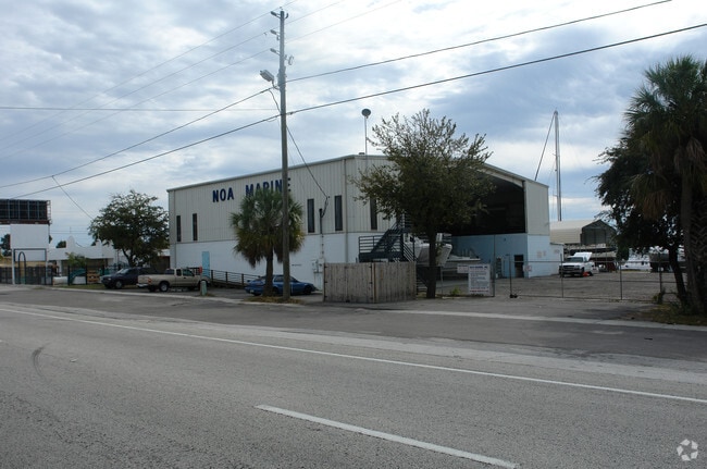
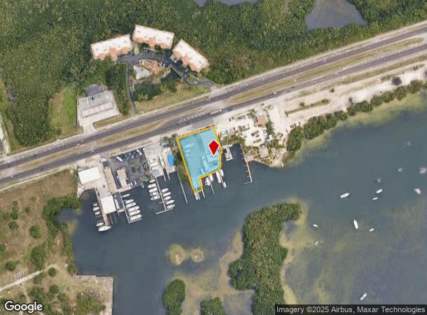
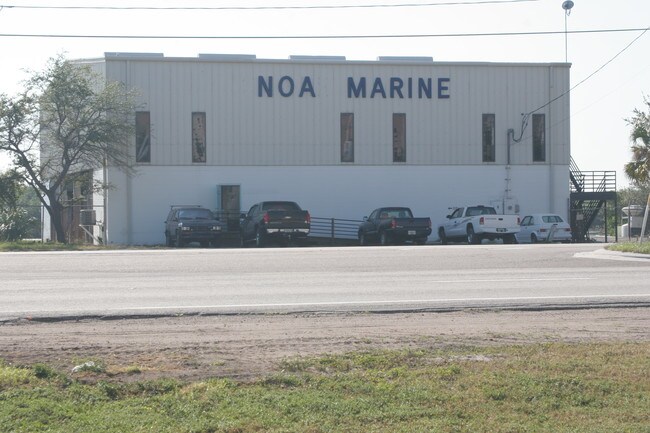
13030 Gandy Blvd N
16-30-17-00000-320-0400
Beg On S R/W Of Gandy Blvd
Autorepair
BEG ON S R/W OF GANDY BLVD 523.04FT NE OF W SEC LINE TH CONT NE 190FT TH S17DE 125FT(S) TO MHW TH SWLY ALG MHW TO PNT 275FT(S) S17DE FROM POB TH N17DW 275FT(S) TO POB TOGETHER WITH SUBM LEASE #521219423 PER O.R. 12261 PG 2201 TILL 06/02/2007
AE
Pinellas
12103C0226H
Florida
2024
0.97 AC
2025
South Pinellas
024411
Tampa/St Petersburg
7,350 SF
Tampa-St. Petersburg-Clearwater, FL
DEMOGRAPHICS near 13030 Gandy Blvd N
1 Mile
3 Mile
5 Mile
2024 Total Population
2,843
32,764
90,306
2029 Population
2,828
32,670
90,926
Pop Growth 2024-2029
(0.53%)
(0.29%)
+ 0.69%
Average Age
36
40
43
2024 Total Households
1,557
17,039
44,301
HH Growth 2024-2029
(0.83%)
(0.59%)
+ 0.52%
Median Household Inc
$71,287
$60,252
$67,852
Avg Household Size
1.80
1.90
2.00
2024 Avg HH Vehicles
1.00
1.00
2.00
Median Home Value
$339,361
$304,412
$286,622
Median Year Built
2003
1981
1976
Nearby Places
Map Layers
Map Styles
 Street
 Aerial
- Restaurants
- Banks
- Shops
- Fitness
- Groceries
PUBLIC TRANSPORTATION
AIRPORT
St Pete-Clearwater International
DRIVE
WALK
Distance
St Pete-Clearwater International
17 min
7.4 mi
Tampa International
DRIVE
WALK
Distance
Tampa International
24 min
13.0 mi
Freight Ports
Port of Tampa Bay
DRIVE
WALK
Distance
Port of Tampa Bay
25 min
15.9 mi
Nearby Properties
Address
Land Use
TOTAL SIZE
Lot Size
Zoning
Address
Land Use
TOTAL SIZE
Lot Size
Zoning
547,276 SF
27.35 AC
Address
Land Use
TOTAL SIZE
Lot Size
Zoning
551,317 SF
52.55 AC
Address
Land Use
TOTAL SIZE
Lot Size
Zoning
749,164 SF
7.11 AC
Address
Land Use
TOTAL SIZE
Lot Size
Zoning
484,229 SF
28 AC
Address
Land Use
TOTAL SIZE
Lot Size
Zoning
350,604 SF
13.21 AC
Address
Land Use
TOTAL SIZE
Lot Size
Zoning
486,722 SF
16.63 AC
Address
Land Use
TOTAL SIZE
Lot Size
Zoning
386,416 SF
18.04 AC
Address
Land Use
TOTAL SIZE
Lot Size
Zoning
308,107 SF
32.37 AC
Address
Land Use
TOTAL SIZE
Lot Size
Zoning
337,137 SF
26.72 AC
M1
Address
Land Use
TOTAL SIZE
Lot Size
Zoning
342,645 SF
12.59 AC
Address
Land Use
TOTAL SIZE
Lot Size
Zoning
243,101 SF
24.86 AC
Address
Land Use
TOTAL SIZE
Lot Size
Zoning
444,770 SF
14.95 AC
Address
Land Use
TOTAL SIZE
Lot Size
Zoning
464,493 SF
17.41 AC
Address
Land Use
TOTAL SIZE
Lot Size
Zoning
572,006 SF
13.01 AC
Address
Land Use
TOTAL SIZE
Lot Size
Zoning
249,361 SF
20.79 AC
Address
Land Use
TOTAL SIZE
Lot Size
Zoning
322,480 SF
26.15 AC
Address
Land Use
TOTAL SIZE
Lot Size
Zoning
286,406 SF
15.26 AC
Address
Land Use
TOTAL SIZE
Lot Size
Zoning
174,071 SF
7.53 AC
Address
Land Use
TOTAL SIZE
Lot Size
Zoning
200,888 SF
10.07 AC
Address
Land Use
TOTAL SIZE
Lot Size
Zoning
288,272 SF
12.34 AC
Address
Land Use
TOTAL SIZE
Lot Size
Zoning
298,116 SF
12.34 AC
Address
Land Use
TOTAL SIZE
Lot Size
Zoning
209,086 SF
17.67 AC
Address
Land Use
TOTAL SIZE
Lot Size
Zoning
175,852 SF
17.39 AC
Address
Land Use
TOTAL SIZE
Lot Size
Zoning
220,499 SF
30.85 AC
Address
Land Use
TOTAL SIZE
Lot Size
Zoning
132,474 SF
7.68 AC
Address
Land Use
TOTAL SIZE
Lot Size
Zoning
216,271 SF
9.94 AC
R6
Address
Land Use
TOTAL SIZE
Lot Size
Zoning
244,896 SF
28.70 AC
Address
Land Use
TOTAL SIZE
Lot Size
Zoning
373,744 SF
18.16 AC
Address
Land Use
TOTAL SIZE
Lot Size
Zoning
163,653 SF
16.68 AC
Address
Land Use
TOTAL SIZE
Lot Size
Zoning
249,005 SF
14.70 AC
The World's #1 Commercial Real Estate Marketplace
Connect with us
© 2025 CoStar Group
The information above has been obtained from sources believed reliable. While we do not doubt its accuracy we have not verified it and make no guarantee, warranty or representation about it. It is your responsibility to independently confirm its accuracy and completeness. Any projections, opinions, assumptions, or estimates used are for example only and do not represent the current or future performance of the property. The value of this transaction to you depends on tax and other factors which should be evaluated by your tax, financial, and legal advisors. You and your advisors should conduct a careful, independent investigation of the property to determine to your satisfaction the suitability of the property for your needs.