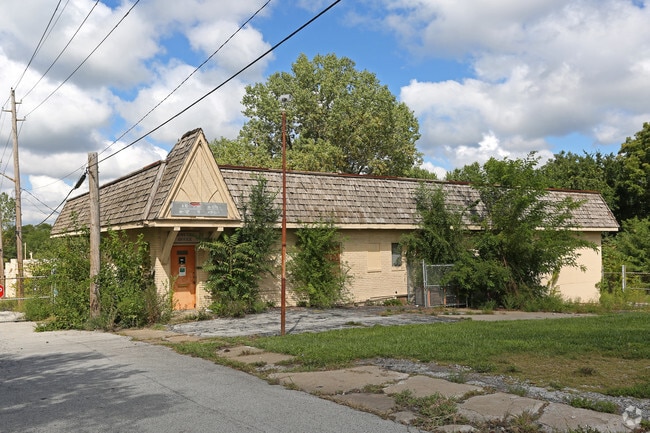
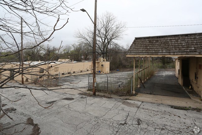
Property Record
1304 W Elm St, Independence, MO 64050
Property Detail
1304 W Elm St
26-330-19-32-00-0-00-000
SEC-03 TWP-49 RNG-32 BEG AT A PT 542.52 N & 25 E OF SW COR OF SE 1/4 OF SW 1/4 TH E 500 TH S TO N LI OF MO PAC RR ROW TH WLY ALG SD ROW TO A PT 25 E OF C/L OF FOREST AVE TH N 3
Lightindustrial
Jackson
B and X Area of moderate flood hazard, usually the area between the limits of the 100-year and 500-year floods.
Missouri
2024
2.13 AC
2025
Independence
011502
Kansas City
8,271 SF
Kansas City, MO-KS
NEARBY LISTINGS FOR SALE OR LEASE
DEMOGRAPHICS near 1304 W Elm St
1 mile
3 mile
5 mile
2025 Total Population
11,857
71,575
151,228
2030 Population
12,053
72,313
152,647
Pop Growth 2025-2030
+ 1.65%
+ 1.03%
+ 0.94%
Average Age
41
41
40
2025 Total Households
5,245
29,984
61,034
HH Growth 2025-2030
+ 1.64%
+ 0.97%
+ 0.85%
Median Household Inc
$43,830
$54,831
$56,780
Avg Household Size
2.10
2.30
2.40
2025 Avg HH Vehicles
1.00
2.00
2.00
Median Home Value
$146,028
$148,888
$160,864
Median Year Built
1950
1957
1964
Nearby Places
Map Layers
Map Styles
 Street
 Aerial
Layers
 Traffic
 Biking
Places
Listings with unknown addresses are not visible on the map
- Restaurants
- Banks
- Shops
- Fitness
- Groceries
PUBLIC TRANSPORTATION
COMMUTER RAIL
Independence Amtrak Station (Lincoln Service Missouri River Runner - Amtrak, Missouri River Runner - Amtrak)
Drive
Walk
Distance
Independence Amtrak Station (Lincoln Service Missouri River Runner - Amtrak, Missouri River Runner - Amtrak)
0 min
4 min
0.2 mi
Kansas City (Lincoln Service Missouri River Runner - Amtrak, Missouri River Runner - Amtrak, Southwest Chief - Amtrak)
Drive
Walk
Distance
Kansas City (Lincoln Service Missouri River Runner - Amtrak, Missouri River Runner - Amtrak, Southwest Chief - Amtrak)
19 min
9.5 mi
AIRPORT
Kansas City International
Drive
Walk
Distance
Kansas City International
41 min
30.0 mi
Freight Ports
Tulsa Port Of Catoosa
Drive
Walk
Distance
Tulsa Port Of Catoosa
277 min
244.2 mi
Nearby Properties
Address
Land Use
TOTAL SIZE
Lot Size
Zoning
Address
Land Use
TOTAL SIZE
Lot Size
Zoning
519,315 SF
28.47 AC
Address
Land Use
TOTAL SIZE
Lot Size
Zoning
7,962 SF
7.80 AC
Address
Land Use
TOTAL SIZE
Lot Size
Zoning
455,100 SF
42.02 AC
Address
Land Use
TOTAL SIZE
Lot Size
Zoning
123,305 SF
15.51 AC
Address
Land Use
TOTAL SIZE
Lot Size
Zoning
64,318 SF
32.40 AC
Address
Land Use
TOTAL SIZE
Lot Size
Zoning
213,615 SF
15.50 AC
Address
Land Use
TOTAL SIZE
Lot Size
Zoning
74,801 SF
8.93 AC
Address
Land Use
TOTAL SIZE
Lot Size
Zoning
157,666 SF
18.54 AC
Address
Land Use
TOTAL SIZE
Lot Size
Zoning
139,713 SF
15.70 AC
Address
Land Use
TOTAL SIZE
Lot Size
Zoning
13,227 SF
287 AC
Address
Land Use
TOTAL SIZE
Lot Size
Zoning
71,339 SF
0.68 AC
Address
Land Use
TOTAL SIZE
Lot Size
Zoning
113,667 SF
6.31 AC
Address
Land Use
TOTAL SIZE
Lot Size
Zoning
190,810 SF
26.90 AC
Address
Land Use
TOTAL SIZE
Lot Size
Zoning
55,985 SF
20.93 AC
Address
Land Use
TOTAL SIZE
Lot Size
Zoning
36,883 SF
14.60 AC
Address
Land Use
TOTAL SIZE
Lot Size
Zoning
286,490 SF
37.30 AC
Address
Land Use
TOTAL SIZE
Lot Size
Zoning
66,168 SF
44.98 AC
Address
Land Use
TOTAL SIZE
Lot Size
Zoning
153,774 SF
Address
Land Use
TOTAL SIZE
Lot Size
Zoning
39,120 SF
1.87 AC
Address
Land Use
TOTAL SIZE
Lot Size
Zoning
50,900 SF
13.80 AC
Address
Land Use
TOTAL SIZE
Lot Size
Zoning
58,946 SF
0.98 AC
Address
Land Use
TOTAL SIZE
Lot Size
Zoning
67,282 SF
4 AC
Address
Land Use
TOTAL SIZE
Lot Size
Zoning
58,800 SF
5.72 AC
Address
Land Use
TOTAL SIZE
Lot Size
Zoning
62,230 SF
11.80 AC
Address
Land Use
TOTAL SIZE
Lot Size
Zoning
69,203 SF
11.35 AC
Address
Land Use
TOTAL SIZE
Lot Size
Zoning
93,834 SF
4.80 AC
Address
Land Use
TOTAL SIZE
Lot Size
Zoning
10,420 SF
2.74 AC
Address
Land Use
TOTAL SIZE
Lot Size
Zoning
62,686 SF
1.98 AC
Address
Land Use
TOTAL SIZE
Lot Size
Zoning
70,772 SF
25.59 AC
Address
Land Use
TOTAL SIZE
Lot Size
Zoning
41,101 SF
4.46 AC
The World's #1 Commercial Real Estate Marketplace
Connect with us
© 2026 CoStar Group
The information above has been obtained from sources believed reliable. While we do not doubt its accuracy we have not verified it and make no guarantee, warranty or representation about it. It is your responsibility to independently confirm its accuracy and completeness. Any projections, opinions, assumptions, or estimates used are for example only and do not represent the current or future performance of the property. The value of this transaction to you depends on tax and other factors which should be evaluated by your tax, financial, and legal advisors. You and your advisors should conduct a careful, independent investigation of the property to determine to your satisfaction the suitability of the property for your needs.