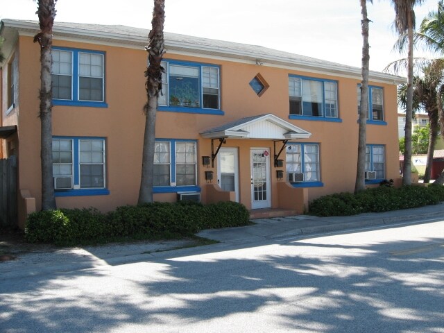
Property Record
13047 Gulf Blvd, Madeira Beach, FL 33708

Save to a Folder
{{folder.Name}}
{{folder.ListingIds.length}} Properties
{{folder.ListingIds.length}} Property
Create a New Folder
Property Detail
13047 Gulf Blvd
Tampa-St. Petersburg-Clearwater, FL
WILLIAMS, BILL MADEIRA HARBOR SUB LOT 1 TOGETHER WITH THAT VAC PART OF SR 699 DESC AS FROM MOST WLY COR SD LOT 1 TH S39D 1009E 11.08FT TH CUR LT RAD 523.69FT ARC 28.76FT CB S40D4432.5E 28.76FT TH S38D1951W 11.47FT TH N38D5432W 24.91FT TH CUR RT RAD 2
15-31-15-97812-000-0010
Pinellas
Multifamilydwelling
Florida
AE The base floodplain where base flood elevations are provided. AE Zones are now used on new format FIRMs instead of A1-A30 Zones.
1
2024
0.10 AC
2025
South Pinellas
027802
Tampa/St Petersburg
3,076 SF
NEARBY LISTINGS FOR SALE OR LEASE
DEMOGRAPHICS near 13047 Gulf Blvd
1 mile
3 mile
5 mile
2025 Total Population
5,659
39,165
144,743
2030 Population
5,983
40,376
147,053
Pop Growth 2025-2030
+ 5.73%
+ 3.09%
+ 1.60%
Average Age
55
52
50
2025 Total Households
3,115
19,853
69,529
HH Growth 2025-2030
+ 5.65%
+ 3.26%
+ 1.75%
Median Household Inc
$89,631
$84,997
$76,141
Avg Household Size
1.80
1.90
2.00
2025 Avg HH Vehicles
2.00
2.00
2.00
Median Home Value
$727,080
$497,331
$403,498
Median Year Built
1973
1970
1971
Nearby Places
Map Layers
Map Styles
 Street
 Aerial
Layers
 Traffic
 Biking
Places
Listings with unknown addresses are not visible on the map
- Restaurants
- Banks
- Shops
- Fitness
- Groceries
PUBLIC TRANSPORTATION
AIRPORT
St Pete-Clearwater International
Drive
Walk
Distance
St Pete-Clearwater International
35 min
16.5 mi
Tampa International
Drive
Walk
Distance
Tampa International
45 min
27.2 mi
Freight Ports
Port Manatee
Drive
Walk
Distance
Port Manatee
48 min
31.0 mi
Nearby Properties
Address
Land Use
TOTAL SIZE
Lot Size
Zoning
Address
Land Use
TOTAL SIZE
Lot Size
Zoning
2,167,184 SF
297.75 AC
PSP
Address
Land Use
TOTAL SIZE
Lot Size
Zoning
453,486 SF
15.73 AC
Address
Land Use
TOTAL SIZE
Lot Size
Zoning
150,235 SF
17.90 AC
Address
Land Use
TOTAL SIZE
Lot Size
Zoning
156,994 SF
29.11 AC
Address
Land Use
TOTAL SIZE
Lot Size
Zoning
142,281 SF
1.57 AC
Address
Land Use
TOTAL SIZE
Lot Size
Zoning
29,644 SF
19.13 AC
Address
Land Use
TOTAL SIZE
Lot Size
Zoning
145,619 SF
1.68 AC
Address
Land Use
TOTAL SIZE
Lot Size
Zoning
160,086 SF
1.18 AC
Address
Land Use
TOTAL SIZE
Lot Size
Zoning
204,891 SF
18.20 AC
Address
Land Use
TOTAL SIZE
Lot Size
Zoning
4,704 SF
3.36 AC
Address
Land Use
TOTAL SIZE
Lot Size
Zoning
176,209 SF
27.52 AC
Address
Land Use
TOTAL SIZE
Lot Size
Zoning
151,421 SF
1.86 AC
Address
Land Use
TOTAL SIZE
Lot Size
Zoning
49,898 SF
77.25 AC
Address
Land Use
TOTAL SIZE
Lot Size
Zoning
119,580 SF
4.18 AC
Address
Land Use
TOTAL SIZE
Lot Size
Zoning
84,008 SF
1.49 AC
Address
Land Use
TOTAL SIZE
Lot Size
Zoning
6,531 SF
357.94 AC
PC
Address
Land Use
TOTAL SIZE
Lot Size
Zoning
Address
Land Use
TOTAL SIZE
Lot Size
Zoning
132,714 SF
14.83 AC
UZ
Address
Land Use
TOTAL SIZE
Lot Size
Zoning
5,590 SF
6.38 AC
Address
Land Use
TOTAL SIZE
Lot Size
Zoning
139,181 SF
22.21 AC
R2
Address
Land Use
TOTAL SIZE
Lot Size
Zoning
57,532 SF
6.96 AC
Address
Land Use
TOTAL SIZE
Lot Size
Zoning
68,675 SF
2.07 AC
Address
Land Use
TOTAL SIZE
Lot Size
Zoning
64,888 SF
1.39 AC
Address
Land Use
TOTAL SIZE
Lot Size
Zoning
23,571 SF
55.32 AC
PSP
Address
Land Use
TOTAL SIZE
Lot Size
Zoning
26,682 SF
1.26 AC
Address
Land Use
TOTAL SIZE
Lot Size
Zoning
98,557 SF
6.92 AC
Address
Land Use
TOTAL SIZE
Lot Size
Zoning
60,996 SF
4.52 AC
Address
Land Use
TOTAL SIZE
Lot Size
Zoning
48,022 SF
3.44 AC
Address
Land Use
TOTAL SIZE
Lot Size
Zoning
71,692 SF
2.04 AC
Address
Land Use
TOTAL SIZE
Lot Size
Zoning
5,642 SF
17.16 AC
The World's #1 Commercial Real Estate Marketplace
Connect with us
© 2026 CoStar Group
The information above has been obtained from sources believed reliable. While we do not doubt its accuracy we have not verified it and make no guarantee, warranty or representation about it. It is your responsibility to independently confirm its accuracy and completeness. Any projections, opinions, assumptions, or estimates used are for example only and do not represent the current or future performance of the property. The value of this transaction to you depends on tax and other factors which should be evaluated by your tax, financial, and legal advisors. You and your advisors should conduct a careful, independent investigation of the property to determine to your satisfaction the suitability of the property for your needs.