Property Record
S St Rte 682 Hwy, , OH
NEARBY LISTINGS FOR SALE OR LEASE
-
-
View all listings for sale on LoopNet.com
Property Detail
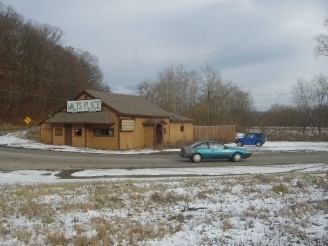
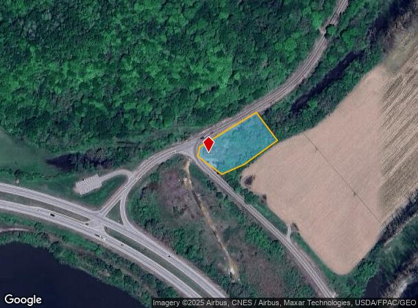
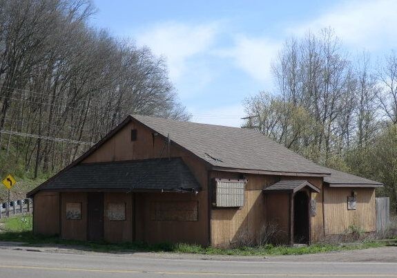
S St Rte 682 Hwy
Bartavern
14-10-00 SEC 25-26 1.17AC
AE
Athens
39009C0094D
Ohio
2024
1.17 AC
2024
Other Market Areas
9734001044
Athens, OH
1,518 SF
G01-00100455-00
DEMOGRAPHICS near S St Rte 682 Hwy
1 Mile
3 Mile
5 Mile
2024 Total Population
1,026
5,221
21,155
2029 Population
1,009
5,190
20,934
Pop Growth 2024-2029
(1.66%)
(0.59%)
(1.04%)
Average Age
40
41
34
2024 Total Households
456
2,389
8,571
HH Growth 2024-2029
(1.75%)
(0.67%)
(0.56%)
Median Household Inc
$65,316
$58,841
$42,626
Avg Household Size
2.20
2.10
2.20
2024 Avg HH Vehicles
2.00
2.00
2.00
Median Home Value
$180,644
$198,511
$193,798
Median Year Built
1978
1983
1974
Nearby Places
Map Layers
Map Styles
 Street
 Aerial
- Restaurants
- Banks
- Shops
- Fitness
- Groceries
SALE & LEASE HISTORY
LISTING DATE
SALE/LEASE

Sep 25, 2016
For Lease
Oct 17, 2017
For Sale
Nearby Properties
Address
Land Use
TOTAL SIZE
Lot Size
Zoning
Address
Land Use
TOTAL SIZE
Lot Size
Zoning
157,903 SF
14.39 AC
Address
Land Use
TOTAL SIZE
Lot Size
Zoning
8.28 AC
Address
Land Use
TOTAL SIZE
Lot Size
Zoning
55,028 SF
4.55 AC
Address
Land Use
TOTAL SIZE
Lot Size
Zoning
5 AC
Address
Land Use
TOTAL SIZE
Lot Size
Zoning
97,655 SF
16.48 AC
Address
Land Use
TOTAL SIZE
Lot Size
Zoning
34,812 SF
1.37 AC
Address
Land Use
TOTAL SIZE
Lot Size
Zoning
40,528 SF
10.52 AC
Address
Land Use
TOTAL SIZE
Lot Size
Zoning
47,921 SF
129.50 AC
Address
Land Use
TOTAL SIZE
Lot Size
Zoning
25,034 SF
9.32 AC
Address
Land Use
TOTAL SIZE
Lot Size
Zoning
27,072 SF
3.48 AC
Address
Land Use
TOTAL SIZE
Lot Size
Zoning
53,637 SF
9.87 AC
Address
Land Use
TOTAL SIZE
Lot Size
Zoning
19,177 SF
5.66 AC
Address
Land Use
TOTAL SIZE
Lot Size
Zoning
29,109 SF
1.45 AC
Address
Land Use
TOTAL SIZE
Lot Size
Zoning
22,500 SF
0.63 AC
Address
Land Use
TOTAL SIZE
Lot Size
Zoning
29,600 SF
2.44 AC
Address
Land Use
TOTAL SIZE
Lot Size
Zoning
18,426 SF
3 AC
Address
Land Use
TOTAL SIZE
Lot Size
Zoning
7,028 SF
3.31 AC
Address
Land Use
TOTAL SIZE
Lot Size
Zoning
7,960 SF
2 AC
Address
Land Use
TOTAL SIZE
Lot Size
Zoning
0.22 AC
Address
Land Use
TOTAL SIZE
Lot Size
Zoning
15,481 SF
0.45 AC
Address
Land Use
TOTAL SIZE
Lot Size
Zoning
18,934 SF
2.07 AC
Address
Land Use
TOTAL SIZE
Lot Size
Zoning
7,711 SF
3 AC
Address
Land Use
TOTAL SIZE
Lot Size
Zoning
27,024 SF
0.90 AC
Address
Land Use
TOTAL SIZE
Lot Size
Zoning
485.68 AC
Address
Land Use
TOTAL SIZE
Lot Size
Zoning
414.34 AC
Address
Land Use
TOTAL SIZE
Lot Size
Zoning
11,719 SF
3.81 AC
Address
Land Use
TOTAL SIZE
Lot Size
Zoning
59,500 SF
2.55 AC
Address
Land Use
TOTAL SIZE
Lot Size
Zoning
21,200 SF
1.78 AC
Address
Land Use
TOTAL SIZE
Lot Size
Zoning
405.29 AC
Address
Land Use
TOTAL SIZE
Lot Size
Zoning
14,812 SF
2.68 AC
The World's #1 Commercial Real Estate Marketplace
Connect with us
© 2025 CoStar Group
The information above has been obtained from sources believed reliable. While we do not doubt its accuracy we have not verified it and make no guarantee, warranty or representation about it. It is your responsibility to independently confirm its accuracy and completeness. Any projections, opinions, assumptions, or estimates used are for example only and do not represent the current or future performance of the property. The value of this transaction to you depends on tax and other factors which should be evaluated by your tax, financial, and legal advisors. You and your advisors should conduct a careful, independent investigation of the property to determine to your satisfaction the suitability of the property for your needs.