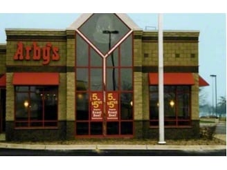
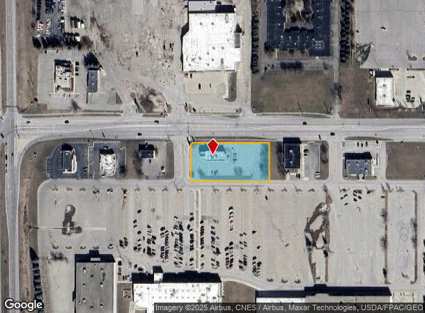
Property Record
1305 18Th Ave Nw, Austin, MN 55912

NEARBY LISTINGS FOR SALE OR LEASE
Property Detail
1305 18Th Ave Nw
Austin, MN
Oak Park Mall Subdivision
34-521-0040
OAK PARK MALL SUBDIVISION 34521 001 LOT 4 & APPROX E59FT LOT 3 DOC #535690
Restaurantdrivein
Mower
X
Minnesota
27099C0186D
3-4
2025
1.14 AC
2025
Minnesota South Area
000100
Other Market Areas
3,713 SF
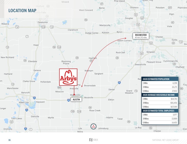
DEMOGRAPHICS near 1305 18Th Ave Nw
1 Mile
3 Mile
5 Mile
2024 Total Population
5,442
28,017
29,280
2029 Population
5,522
28,417
29,674
Pop Growth 2024-2029
+ 1.47%
+ 1.43%
+ 1.35%
Average Age
38
39
39
2024 Total Households
2,128
10,953
11,468
HH Growth 2024-2029
+ 1.46%
+ 1.42%
+ 1.33%
Median Household Inc
$51,905
$56,580
$57,283
Avg Household Size
2.50
2.50
2.50
2024 Avg HH Vehicles
2.00
2.00
2.00
Median Home Value
$150,550
$141,307
$144,585
Median Year Built
1958
1956
1956
Nearby Places
Map Layers
Map Styles
 Street
 Aerial
- Restaurants
- Banks
- Shops
- Fitness
- Groceries
PUBLIC TRANSPORTATION
AIRPORT
Rochester International
DRIVE
WALK
Distance
Rochester International
43 min
36.0 mi
Freight Ports
Port Milwaukee
DRIVE
WALK
Distance
Port Milwaukee
340 min
309.6 mi
SALE & LEASE HISTORY
LISTING DATE
SALE/LEASE

Sep 23, 2016
For Sale
Oct 17, 2019
For Sale
Dec 29, 2020
For Sale
Dec 15, 2020
For Sale
Dec 12, 2020
For Sale
Nearby Properties
Address
Land Use
TOTAL SIZE
Lot Size
Zoning
Address
Land Use
TOTAL SIZE
Lot Size
Zoning
220,079 SF
1.77 AC
Address
Land Use
TOTAL SIZE
Lot Size
Zoning
162,255 SF
14.56 AC
Address
Land Use
TOTAL SIZE
Lot Size
Zoning
104,160 SF
66.71 AC
Address
Land Use
TOTAL SIZE
Lot Size
Zoning
128,037 SF
5.41 AC
Address
Land Use
TOTAL SIZE
Lot Size
Zoning
96,056 SF
0.50 AC
Address
Land Use
TOTAL SIZE
Lot Size
Zoning
76,500 SF
1.44 AC
Address
Land Use
TOTAL SIZE
Lot Size
Zoning
101,935 SF
23.63 AC
Address
Land Use
TOTAL SIZE
Lot Size
Zoning
38,988 SF
7.49 AC
Address
Land Use
TOTAL SIZE
Lot Size
Zoning
53,316 SF
1.23 AC
Address
Land Use
TOTAL SIZE
Lot Size
Zoning
86,076 SF
1.94 AC
Address
Land Use
TOTAL SIZE
Lot Size
Zoning
109,096 SF
3.57 AC
Address
Land Use
TOTAL SIZE
Lot Size
Zoning
54,000 SF
3.83 AC
Address
Land Use
TOTAL SIZE
Lot Size
Zoning
Address
Land Use
TOTAL SIZE
Lot Size
Zoning
91,839 SF
2.74 AC
Address
Land Use
TOTAL SIZE
Lot Size
Zoning
116,305 SF
2.38 AC
Address
Land Use
TOTAL SIZE
Lot Size
Zoning
85,056 SF
20.55 AC
Address
Land Use
TOTAL SIZE
Lot Size
Zoning
324,011 SF
3.41 AC
Address
Land Use
TOTAL SIZE
Lot Size
Zoning
44,123 SF
8.69 AC
Address
Land Use
TOTAL SIZE
Lot Size
Zoning
107,690 SF
2.35 AC
Address
Land Use
TOTAL SIZE
Lot Size
Zoning
204,695 SF
19.86 AC
Address
Land Use
TOTAL SIZE
Lot Size
Zoning
52,186 SF
50.77 AC
Address
Land Use
TOTAL SIZE
Lot Size
Zoning
167,880 SF
9 AC
Address
Land Use
TOTAL SIZE
Lot Size
Zoning
17,600 SF
3.82 AC
Address
Land Use
TOTAL SIZE
Lot Size
Zoning
42,668 SF
2.35 AC
Address
Land Use
TOTAL SIZE
Lot Size
Zoning
16,848 SF
48.31 AC
Address
Land Use
TOTAL SIZE
Lot Size
Zoning
70,739 SF
9.55 AC
Address
Land Use
TOTAL SIZE
Lot Size
Zoning
65,952 SF
7.62 AC
Address
Land Use
TOTAL SIZE
Lot Size
Zoning
61,052 SF
2.21 AC
Address
Land Use
TOTAL SIZE
Lot Size
Zoning
56,676 SF
6.60 AC
Address
Land Use
TOTAL SIZE
Lot Size
Zoning
111,238 SF
17.85 AC
The World's #1 Commercial Real Estate Marketplace
Connect with us
© 2025 CoStar Group
The information above has been obtained from sources believed reliable. While we do not doubt its accuracy we have not verified it and make no guarantee, warranty or representation about it. It is your responsibility to independently confirm its accuracy and completeness. Any projections, opinions, assumptions, or estimates used are for example only and do not represent the current or future performance of the property. The value of this transaction to you depends on tax and other factors which should be evaluated by your tax, financial, and legal advisors. You and your advisors should conduct a careful, independent investigation of the property to determine to your satisfaction the suitability of the property for your needs.