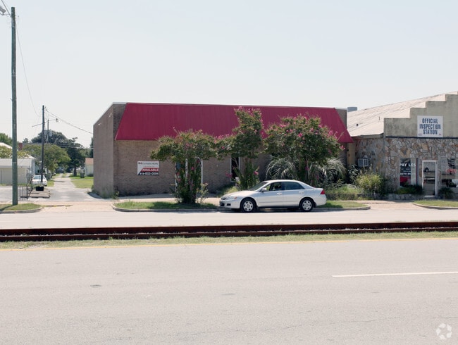
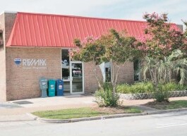
Property Record
1305 Arendell St, Morehead City, NC 28557
NEARBY LISTINGS FOR SALE OR LEASE
-
-
View all Morehead City listings for lease on LoopNet.com
Property Detail
1305 Arendell St
6386.18.41.8368000
Morehead City
Restaurantbuilding
L13 B21 MOREHEAD CITY
X
Carteret
3720638600J
North Carolina
2025
13
2025
0.14 AC
970403
Other Market Areas
3,573 SF
Morehead City, NC
DEMOGRAPHICS near 1305 Arendell St
1 Mile
3 Mile
5 Mile
2024 Total Population
2,799
12,235
22,248
2029 Population
3,013
12,931
23,501
Pop Growth 2024-2029
+ 7.65%
+ 5.69%
+ 5.63%
Average Age
47
47
48
2024 Total Households
1,330
5,908
10,629
HH Growth 2024-2029
+ 7.59%
+ 5.86%
+ 5.74%
Median Household Inc
$46,948
$54,823
$57,072
Avg Household Size
2.00
2.00
2.00
2024 Avg HH Vehicles
2.00
2.00
2.00
Median Home Value
$320,000
$310,994
$308,597
Median Year Built
1961
1983
1983
Nearby Places
- Restaurants
- Banks
- Shops
- Fitness
- Groceries
SALE & LEASE HISTORY
LISTING DATE
SALE/LEASE

Sep 25, 2016
For Lease
Sep 24, 2016
For Sale
Jul 27, 2018
For Lease
Jul 27, 2018
For Sale
Apr 03, 2017
For Sale
Nearby Properties
Address
Land Use
TOTAL SIZE
Lot Size
Zoning
Address
Land Use
TOTAL SIZE
Lot Size
Zoning
41,661 SF
14.90 AC
Address
Land Use
TOTAL SIZE
Lot Size
Zoning
124,220 SF
105.71 AC
Address
Land Use
TOTAL SIZE
Lot Size
Zoning
33,136 SF
24.01 AC
Address
Land Use
TOTAL SIZE
Lot Size
Zoning
6,696 SF
19.43 AC
Address
Land Use
TOTAL SIZE
Lot Size
Zoning
201,240 SF
14.10 AC
Address
Land Use
TOTAL SIZE
Lot Size
Zoning
52,212 SF
17.61 AC
Address
Land Use
TOTAL SIZE
Lot Size
Zoning
81,815 SF
5.58 AC
Address
Land Use
TOTAL SIZE
Lot Size
Zoning
4,680 SF
14.53 AC
Address
Land Use
TOTAL SIZE
Lot Size
Zoning
92,731 SF
3.53 AC
Address
Land Use
TOTAL SIZE
Lot Size
Zoning
156,266 SF
13.19 AC
Address
Land Use
TOTAL SIZE
Lot Size
Zoning
56,174 SF
5.47 AC
Address
Land Use
TOTAL SIZE
Lot Size
Zoning
63,071 SF
31.87 AC
Address
Land Use
TOTAL SIZE
Lot Size
Zoning
12,090 SF
12.03 AC
Address
Land Use
TOTAL SIZE
Lot Size
Zoning
55,768 SF
4.79 AC
Address
Land Use
TOTAL SIZE
Lot Size
Zoning
24,100 SF
15.16 AC
Address
Land Use
TOTAL SIZE
Lot Size
Zoning
53,819 SF
7 AC
Address
Land Use
TOTAL SIZE
Lot Size
Zoning
35,136 SF
6.49 AC
Address
Land Use
TOTAL SIZE
Lot Size
Zoning
5,648 SF
7.69 AC
Address
Land Use
TOTAL SIZE
Lot Size
Zoning
22,188 SF
4.76 AC
Address
Land Use
TOTAL SIZE
Lot Size
Zoning
52,962 SF
5.02 AC
Address
Land Use
TOTAL SIZE
Lot Size
Zoning
44,796 SF
2.75 AC
Address
Land Use
TOTAL SIZE
Lot Size
Zoning
9,668 SF
156.38 AC
Address
Land Use
TOTAL SIZE
Lot Size
Zoning
17,177 SF
1.19 AC
Address
Land Use
TOTAL SIZE
Lot Size
Zoning
1,916 SF
4.83 AC
Address
Land Use
TOTAL SIZE
Lot Size
Zoning
49,724 SF
8.81 AC
Address
Land Use
TOTAL SIZE
Lot Size
Zoning
2,927 SF
2.29 AC
Address
Land Use
TOTAL SIZE
Lot Size
Zoning
30,337 SF
2.06 AC
Address
Land Use
TOTAL SIZE
Lot Size
Zoning
15,434 SF
1.38 AC
Address
Land Use
TOTAL SIZE
Lot Size
Zoning
The World's #1 Commercial Real Estate Marketplace
Connect with us
© 2025 CoStar Group
The information above has been obtained from sources believed reliable. While we do not doubt its accuracy we have not verified it and make no guarantee, warranty or representation about it. It is your responsibility to independently confirm its accuracy and completeness. Any projections, opinions, assumptions, or estimates used are for example only and do not represent the current or future performance of the property. The value of this transaction to you depends on tax and other factors which should be evaluated by your tax, financial, and legal advisors. You and your advisors should conduct a careful, independent investigation of the property to determine to your satisfaction the suitability of the property for your needs.