Property Record
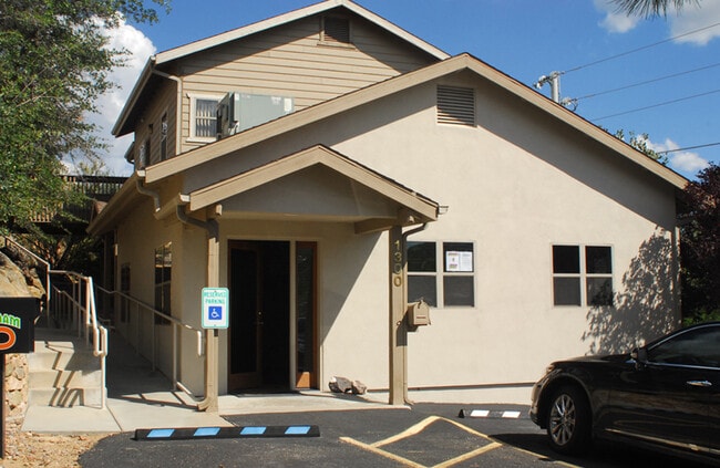
1306 W Gurley St, Prescott, AZ 86305


NEARBY LISTINGS FOR SALE OR LEASE
Property Detail
1306 W Gurley St
Prescott, AZ
Granite Heights
111-12-044C
IRREG PCL SW COR LYING APPROX 800N & 470E FROM S4 COR SEC 32- 1 4-2W CONT APPROX .79AC
Medicalbuilding
Yavapai
X
Arizona
04025C2061H
8
2024
0.79 AC
2026
Downtown Prescott
001002
Other Market Areas
5,392 SF
DEMOGRAPHICS near 1306 W Gurley St
1 Mile
3 Mile
5 Mile
2024 Total Population
7,630
36,008
54,166
2029 Population
8,559
40,425
60,954
Pop Growth 2024-2029
+ 12.18%
+ 12.27%
+ 12.53%
Average Age
48
51
52
2024 Total Households
3,788
17,508
26,472
HH Growth 2024-2029
+ 12.59%
+ 12.71%
+ 12.98%
Median Household Inc
$53,521
$60,402
$62,087
Avg Household Size
1.90
2.00
2.00
2024 Avg HH Vehicles
2.00
2.00
2.00
Median Home Value
$372,523
$443,317
$460,531
Median Year Built
1977
1984
1990
Nearby Places
Map Layers
Map Styles
 Street
 Aerial
- Restaurants
- Banks
- Shops
- Fitness
- Groceries
SALE & LEASE HISTORY
LISTING DATE
SALE/LEASE

Sep 23, 2016
For Sale
Nov 19, 2020
For Sale
Jun 13, 2018
For Sale
Jan 07, 2019
For Sale
Feb 08, 2024
For Sale
Nearby Properties
Address
Land Use
TOTAL SIZE
Lot Size
Zoning
Address
Land Use
TOTAL SIZE
Lot Size
Zoning
633,861 SF
21.72 AC
Address
Land Use
TOTAL SIZE
Lot Size
Zoning
334,628 SF
15.03 AC
Address
Land Use
TOTAL SIZE
Lot Size
Zoning
288,789 SF
24.01 AC
Address
Land Use
TOTAL SIZE
Lot Size
Zoning
103,382 SF
3.43 AC
Address
Land Use
TOTAL SIZE
Lot Size
Zoning
110,011 SF
8.04 AC
Address
Land Use
TOTAL SIZE
Lot Size
Zoning
17,200 SF
88.32 AC
Address
Land Use
TOTAL SIZE
Lot Size
Zoning
122,130 SF
2.20 AC
Address
Land Use
TOTAL SIZE
Lot Size
Zoning
67,239 SF
Address
Land Use
TOTAL SIZE
Lot Size
Zoning
142,636 SF
1.14 AC
Address
Land Use
TOTAL SIZE
Lot Size
Zoning
30,000 SF
44.55 AC
Address
Land Use
TOTAL SIZE
Lot Size
Zoning
43,046 SF
3.13 AC
Address
Land Use
TOTAL SIZE
Lot Size
Zoning
142,343 SF
39.35 AC
Address
Land Use
TOTAL SIZE
Lot Size
Zoning
114,526 SF
9.68 AC
Address
Land Use
TOTAL SIZE
Lot Size
Zoning
77,751 SF
3.88 AC
Address
Land Use
TOTAL SIZE
Lot Size
Zoning
35,353 SF
1.12 AC
Address
Land Use
TOTAL SIZE
Lot Size
Zoning
160,788 SF
14.05 AC
Address
Land Use
TOTAL SIZE
Lot Size
Zoning
58,352 SF
4.48 AC
Address
Land Use
TOTAL SIZE
Lot Size
Zoning
64,987 SF
2.62 AC
Address
Land Use
TOTAL SIZE
Lot Size
Zoning
48,488 SF
5.50 AC
Address
Land Use
TOTAL SIZE
Lot Size
Zoning
30,638 SF
1.25 AC
Address
Land Use
TOTAL SIZE
Lot Size
Zoning
49,570 SF
2.75 AC
Address
Land Use
TOTAL SIZE
Lot Size
Zoning
98,858 SF
7.05 AC
Address
Land Use
TOTAL SIZE
Lot Size
Zoning
60,978 SF
4.72 AC
Address
Land Use
TOTAL SIZE
Lot Size
Zoning
64,176 SF
3.10 AC
Address
Land Use
TOTAL SIZE
Lot Size
Zoning
140,525 SF
7.64 AC
Address
Land Use
TOTAL SIZE
Lot Size
Zoning
75,262 SF
67.69 AC
Address
Land Use
TOTAL SIZE
Lot Size
Zoning
52,136 SF
0.75 AC
Address
Land Use
TOTAL SIZE
Lot Size
Zoning
79,758 SF
8.78 AC
Address
Land Use
TOTAL SIZE
Lot Size
Zoning
43,896 SF
4.06 AC
Address
Land Use
TOTAL SIZE
Lot Size
Zoning
67,833 SF
5.21 AC
The World's #1 Commercial Real Estate Marketplace
Connect with us
© 2025 CoStar Group
The information above has been obtained from sources believed reliable. While we do not doubt its accuracy we have not verified it and make no guarantee, warranty or representation about it. It is your responsibility to independently confirm its accuracy and completeness. Any projections, opinions, assumptions, or estimates used are for example only and do not represent the current or future performance of the property. The value of this transaction to you depends on tax and other factors which should be evaluated by your tax, financial, and legal advisors. You and your advisors should conduct a careful, independent investigation of the property to determine to your satisfaction the suitability of the property for your needs.