Property Record
13071 Us Route 422, Kittanning, PA 16201

NEARBY LISTINGS FOR SALE OR LEASE
-
-
View all Kittanning listings for sale on LoopNet.com
Property Detail
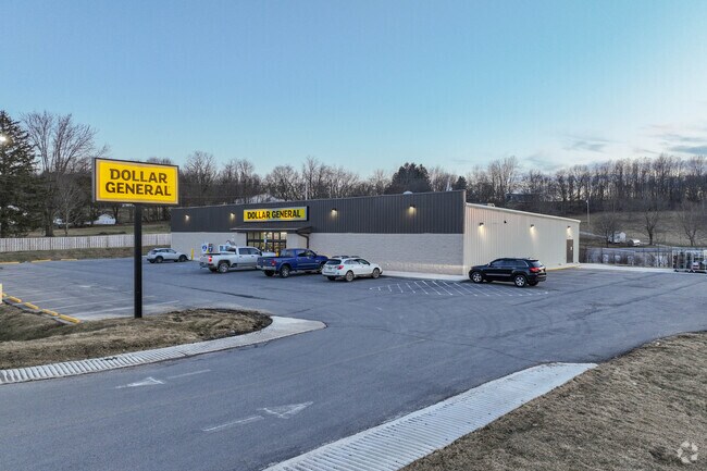
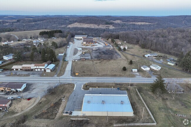
13071 Us Route 422
25-0-050650
Coachman Plan No 1
Storebuilding
NEXT TO TOYS AUTO
X
Armstrong
42005C0340D
Pennsylvania
2025
1.01 AC
2025
Armstrong County
950800
Pittsburgh
10,330 SF
Pittsburgh, PA
DEMOGRAPHICS near 13071 Us Route 422
1 Mile
3 Mile
5 Mile
2024 Total Population
529
2,597
17,289
2029 Population
521
2,540
17,002
Pop Growth 2024-2029
(1.51%)
(2.19%)
(1.66%)
Average Age
48
46
45
2024 Total Households
212
1,071
7,697
HH Growth 2024-2029
(1.42%)
(2.24%)
(1.64%)
Median Household Inc
$74,031
$63,011
$51,718
Avg Household Size
2.30
2.30
2.20
2024 Avg HH Vehicles
2.00
2.00
2.00
Median Home Value
$184,999
$162,318
$114,234
Median Year Built
1978
1967
1954
Nearby Places
Map Layers
Map Styles
 Street
 Aerial
- Restaurants
- Banks
- Shops
- Fitness
- Groceries
SALE & LEASE HISTORY
LISTING DATE
SALE/LEASE

Aug 30, 2022
For Sale
Nearby Properties
Address
Land Use
TOTAL SIZE
Lot Size
Zoning
Address
Land Use
TOTAL SIZE
Lot Size
Zoning
75,000 SF
121.87 AC
Address
Land Use
TOTAL SIZE
Lot Size
Zoning
45,222 SF
3.06 AC
Address
Land Use
TOTAL SIZE
Lot Size
Zoning
116,560 SF
9.03 AC
Address
Land Use
TOTAL SIZE
Lot Size
Zoning
10,324 SF
0.98 AC
Address
Land Use
TOTAL SIZE
Lot Size
Zoning
20,522 SF
4.76 AC
Address
Land Use
TOTAL SIZE
Lot Size
Zoning
13,497 SF
49.49 AC
Address
Land Use
TOTAL SIZE
Lot Size
Zoning
12,084 SF
3.19 AC
Address
Land Use
TOTAL SIZE
Lot Size
Zoning
7,069 SF
3.97 AC
Address
Land Use
TOTAL SIZE
Lot Size
Zoning
Address
Land Use
TOTAL SIZE
Lot Size
Zoning
13,752 SF
4 AC
Address
Land Use
TOTAL SIZE
Lot Size
Zoning
11,664 SF
28.64 AC
Address
Land Use
TOTAL SIZE
Lot Size
Zoning
9,034 SF
0.91 AC
Address
Land Use
TOTAL SIZE
Lot Size
Zoning
11,081 SF
5.97 AC
Address
Land Use
TOTAL SIZE
Lot Size
Zoning
9,368 SF
14.81 AC
Address
Land Use
TOTAL SIZE
Lot Size
Zoning
78,008 SF
20.16 AC
Address
Land Use
TOTAL SIZE
Lot Size
Zoning
11,644 SF
2.76 AC
Address
Land Use
TOTAL SIZE
Lot Size
Zoning
Address
Land Use
TOTAL SIZE
Lot Size
Zoning
1,920 SF
5.41 AC
Address
Land Use
TOTAL SIZE
Lot Size
Zoning
10,830 SF
1.37 AC
Address
Land Use
TOTAL SIZE
Lot Size
Zoning
Address
Land Use
TOTAL SIZE
Lot Size
Zoning
5,000 SF
3.41 AC
Address
Land Use
TOTAL SIZE
Lot Size
Zoning
5,408 SF
34.76 AC
Address
Land Use
TOTAL SIZE
Lot Size
Zoning
25,200 SF
5.29 AC
Address
Land Use
TOTAL SIZE
Lot Size
Zoning
Address
Land Use
TOTAL SIZE
Lot Size
Zoning
Address
Land Use
TOTAL SIZE
Lot Size
Zoning
7,680 SF
24.61 AC
Address
Land Use
TOTAL SIZE
Lot Size
Zoning
5,700 SF
13.86 AC
Address
Land Use
TOTAL SIZE
Lot Size
Zoning
5,923 SF
2.03 AC
Address
Land Use
TOTAL SIZE
Lot Size
Zoning
10,800 SF
11 AC
The World's #1 Commercial Real Estate Marketplace
Connect with us
© 2025 CoStar Group
The information above has been obtained from sources believed reliable. While we do not doubt its accuracy we have not verified it and make no guarantee, warranty or representation about it. It is your responsibility to independently confirm its accuracy and completeness. Any projections, opinions, assumptions, or estimates used are for example only and do not represent the current or future performance of the property. The value of this transaction to you depends on tax and other factors which should be evaluated by your tax, financial, and legal advisors. You and your advisors should conduct a careful, independent investigation of the property to determine to your satisfaction the suitability of the property for your needs.