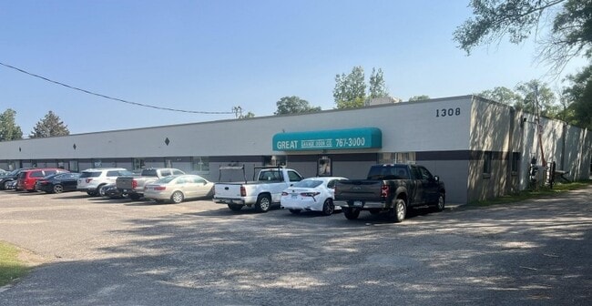
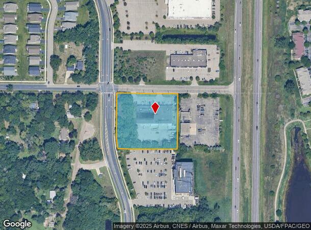
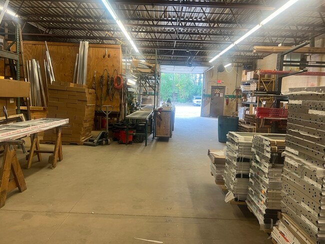
Property Record
1308 113Th Ave Ne, Minneapolis, MN 55434


NEARBY LISTINGS FOR SALE OR LEASE
Property Detail
1308 113Th Ave Ne
Minneapolis-St. Paul-Bloomington, MN-WI
Central Avenue Acres
17-31-23-31-0044
W 257 FT OF E 539 FT OF S 1/2 OF LOT 13 CENTRAL AVE ACRES TOG/W THAT PRT OF N 1/2 SD LOT 13 LYG E OF LINE DRAWN PERP TO N LIN
Industrialgeneral
Anoka
X
Minnesota
27003C0336E
13
2025
2.27 AC
2025
Coon Rapids
050807
Minneapolis/St Paul
19,581 SF
DEMOGRAPHICS near 1308 113Th Ave Ne
1 Mile
3 Mile
5 Mile
2024 Total Population
10,229
75,283
170,413
2029 Population
10,719
78,355
176,723
Pop Growth 2024-2029
+ 4.79%
+ 4.08%
+ 3.70%
Average Age
40
39
39
2024 Total Households
3,865
27,535
62,761
HH Growth 2024-2029
+ 4.86%
+ 4.06%
+ 3.66%
Median Household Inc
$95,949
$91,061
$88,100
Avg Household Size
2.60
2.70
2.60
2024 Avg HH Vehicles
2.00
2.00
2.00
Median Home Value
$292,436
$275,892
$279,936
Median Year Built
2001
1988
1986
Nearby Places
Map Layers
Map Styles
 Street
 Aerial
- Restaurants
- Banks
- Shops
- Fitness
- Groceries
PUBLIC TRANSPORTATION
COMMUTER RAIL
Coon Rapids-Riverdale Station (Northstar Corridor - Northstar Commuter Rail)
DRIVE
WALK
Distance
Coon Rapids-Riverdale Station (Northstar Corridor - Northstar Commuter Rail)
15 min
7.5 mi
Fridley Station (Northstar Corridor - Northstar Commuter Rail)
DRIVE
WALK
Distance
Fridley Station (Northstar Corridor - Northstar Commuter Rail)
15 min
8.5 mi
AIRPORT
Minneapolis-St Paul International/Wold-Chamberlain
DRIVE
WALK
Distance
Minneapolis-St Paul International/Wold-Chamberlain
40 min
26.4 mi
SALE & LEASE HISTORY
LISTING DATE
SALE/LEASE

Sep 25, 2024
For Sale
Apr 28, 2025
For Lease
Nearby Properties
Address
Land Use
TOTAL SIZE
Lot Size
Zoning
Address
Land Use
TOTAL SIZE
Lot Size
Zoning
100,260 SF
74.82 AC
Address
Land Use
TOTAL SIZE
Lot Size
Zoning
1,075 SF
41.99 AC
Address
Land Use
TOTAL SIZE
Lot Size
Zoning
214,300 SF
9.15 AC
Address
Land Use
TOTAL SIZE
Lot Size
Zoning
195,000 SF
Address
Land Use
TOTAL SIZE
Lot Size
Zoning
8,400 SF
10.10 AC
Address
Land Use
TOTAL SIZE
Lot Size
Zoning
Address
Land Use
TOTAL SIZE
Lot Size
Zoning
225,576 SF
6.07 AC
Address
Land Use
TOTAL SIZE
Lot Size
Zoning
14,908 SF
28.38 AC
Address
Land Use
TOTAL SIZE
Lot Size
Zoning
179,853 SF
37.73 AC
Address
Land Use
TOTAL SIZE
Lot Size
Zoning
342,686 SF
13.60 AC
Address
Land Use
TOTAL SIZE
Lot Size
Zoning
192 SF
11.30 AC
Address
Land Use
TOTAL SIZE
Lot Size
Zoning
105,324 SF
13.36 AC
Address
Land Use
TOTAL SIZE
Lot Size
Zoning
76,383 SF
7.60 AC
Address
Land Use
TOTAL SIZE
Lot Size
Zoning
98,642 SF
20.01 AC
Address
Land Use
TOTAL SIZE
Lot Size
Zoning
119,907 SF
36.99 AC
Address
Land Use
TOTAL SIZE
Lot Size
Zoning
122,498 SF
31.67 AC
Address
Land Use
TOTAL SIZE
Lot Size
Zoning
135,994 SF
3.20 AC
Address
Land Use
TOTAL SIZE
Lot Size
Zoning
135,746 SF
8.85 AC
Address
Land Use
TOTAL SIZE
Lot Size
Zoning
162,450 SF
9.97 AC
Address
Land Use
TOTAL SIZE
Lot Size
Zoning
287,568 SF
8.01 AC
Address
Land Use
TOTAL SIZE
Lot Size
Zoning
83,688 SF
5.75 AC
Address
Land Use
TOTAL SIZE
Lot Size
Zoning
179,523 SF
16.58 AC
Address
Land Use
TOTAL SIZE
Lot Size
Zoning
8,410 SF
12.69 AC
Address
Land Use
TOTAL SIZE
Lot Size
Zoning
116,452 SF
8.68 AC
Address
Land Use
TOTAL SIZE
Lot Size
Zoning
120,000 SF
39.44 AC
Address
Land Use
TOTAL SIZE
Lot Size
Zoning
102 SF
3.77 AC
Address
Land Use
TOTAL SIZE
Lot Size
Zoning
23,014 SF
12.95 AC
Address
Land Use
TOTAL SIZE
Lot Size
Zoning
57,600 SF
11.73 AC
Address
Land Use
TOTAL SIZE
Lot Size
Zoning
168,694 SF
10.70 AC
The World's #1 Commercial Real Estate Marketplace
Connect with us
© 2026 CoStar Group
The information above has been obtained from sources believed reliable. While we do not doubt its accuracy we have not verified it and make no guarantee, warranty or representation about it. It is your responsibility to independently confirm its accuracy and completeness. Any projections, opinions, assumptions, or estimates used are for example only and do not represent the current or future performance of the property. The value of this transaction to you depends on tax and other factors which should be evaluated by your tax, financial, and legal advisors. You and your advisors should conduct a careful, independent investigation of the property to determine to your satisfaction the suitability of the property for your needs.