Property Record
1302 Donnelly Ave Sw, Atlanta, GA 30310
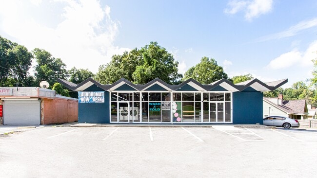

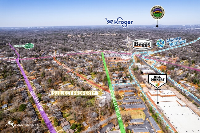

This Property Is For Sale
NEARBY LISTINGS FOR SALE OR LEASE
Property Detail
1302 Donnelly Ave Sw
Atlanta-Sandy Springs-Roswell, GA
Cambridged Commons Ph 01A
14-0139-0004-092-8
KA J & F COIN LAUNDRY AN DRY CLEANING
Storebuilding
Fulton
X
Georgia
13121C0356F
139
2024
0.39 AC
2025
College Park/SW Atl
006000
Atlanta
6,840 SF
DEMOGRAPHICS near 1302 Donnelly Ave Sw
1 Mile
3 Mile
5 Mile
2024 Total Population
14,281
113,190
338,348
2029 Population
14,893
119,292
353,150
Pop Growth 2024-2029
+ 4.29%
+ 5.39%
+ 4.37%
Average Age
40
38
37
2024 Total Households
6,457
47,389
150,783
HH Growth 2024-2029
+ 4.21%
+ 5.62%
+ 4.61%
Median Household Inc
$42,323
$37,637
$61,952
Avg Household Size
2.10
2.20
2.00
2024 Avg HH Vehicles
1.00
1.00
1.00
Median Home Value
$351,309
$269,049
$322,476
Median Year Built
1953
1969
1986
Nearby Places
Map Layers
Map Styles
 Street
 Aerial
- Restaurants
- Banks
- Shops
- Fitness
- Groceries
PUBLIC TRANSPORTATION
COMMUTER RAIL
Atlanta (Crescent - Amtrak)
DRIVE
WALK
Distance
Atlanta (Crescent - Amtrak)
14 min
7.2 mi
AIRPORT
Hartsfield - Jackson Atlanta International
DRIVE
WALK
Distance
Hartsfield - Jackson Atlanta International
18 min
9.8 mi
Freight Ports
Georgia Ports - Savannah
DRIVE
WALK
Distance
Georgia Ports - Savannah
281 min
249.1 mi
Nearby Properties
Address
Land Use
TOTAL SIZE
Lot Size
Zoning
Address
Land Use
TOTAL SIZE
Lot Size
Zoning
19.94 AC
SPI1
Address
Land Use
TOTAL SIZE
Lot Size
Zoning
11.74 AC
I1
Address
Land Use
TOTAL SIZE
Lot Size
Zoning
9.80 AC
C5
Address
Land Use
TOTAL SIZE
Lot Size
Zoning
9 AC
C5
Address
Land Use
TOTAL SIZE
Lot Size
Zoning
10.27 AC
C5
Address
Land Use
TOTAL SIZE
Lot Size
Zoning
61.57 AC
C5
Address
Land Use
TOTAL SIZE
Lot Size
Zoning
1.55 AC
SPI1
Address
Land Use
TOTAL SIZE
Lot Size
Zoning
7 AC
C3
Address
Land Use
TOTAL SIZE
Lot Size
Zoning
1,589,465 SF
3.41 AC
SPI1
Address
Land Use
TOTAL SIZE
Lot Size
Zoning
3.62 AC
SPI1
Address
Land Use
TOTAL SIZE
Lot Size
Zoning
3,588,720 SF
1.32 AC
SPI1
Address
Land Use
TOTAL SIZE
Lot Size
Zoning
631,858 SF
1.33 AC
C5C
Address
Land Use
TOTAL SIZE
Lot Size
Zoning
1.91 AC
I1
Address
Land Use
TOTAL SIZE
Lot Size
Zoning
34 AC
OI
Address
Land Use
TOTAL SIZE
Lot Size
Zoning
1,553,747 SF
2 AC
SPI1
Address
Land Use
TOTAL SIZE
Lot Size
Zoning
541,092 SF
0.53 AC
SPI1
Address
Land Use
TOTAL SIZE
Lot Size
Zoning
498,515 SF
3.41 AC
C1
Address
Land Use
TOTAL SIZE
Lot Size
Zoning
632,090 SF
1.01 AC
SPI1
Address
Land Use
TOTAL SIZE
Lot Size
Zoning
351,438 SF
0.44 AC
SPI1
Address
Land Use
TOTAL SIZE
Lot Size
Zoning
718,622 SF
4.05 AC
I1
Address
Land Use
TOTAL SIZE
Lot Size
Zoning
0.45 AC
SPI1
Address
Land Use
TOTAL SIZE
Lot Size
Zoning
418,252 SF
3.48 AC
I2
Address
Land Use
TOTAL SIZE
Lot Size
Zoning
979,670 SF
0.82 AC
SPI1
Address
Land Use
TOTAL SIZE
Lot Size
Zoning
659,464 SF
0.74 AC
SPI1
Address
Land Use
TOTAL SIZE
Lot Size
Zoning
903,364 SF
1.08 AC
SPI1
Address
Land Use
TOTAL SIZE
Lot Size
Zoning
1,146,402 SF
4.74 AC
SPI1
Address
Land Use
TOTAL SIZE
Lot Size
Zoning
469,344 SF
3.62 AC
C3
Address
Land Use
TOTAL SIZE
Lot Size
Zoning
564,481 SF
6.71 AC
I2
Address
Land Use
TOTAL SIZE
Lot Size
Zoning
9.85 AC
SPI1
Address
Land Use
TOTAL SIZE
Lot Size
Zoning
357,153 SF
0.60 AC
SPI1
The World's #1 Commercial Real Estate Marketplace
Connect with us
© 2025 CoStar Group
The information above has been obtained from sources believed reliable. While we do not doubt its accuracy we have not verified it and make no guarantee, warranty or representation about it. It is your responsibility to independently confirm its accuracy and completeness. Any projections, opinions, assumptions, or estimates used are for example only and do not represent the current or future performance of the property. The value of this transaction to you depends on tax and other factors which should be evaluated by your tax, financial, and legal advisors. You and your advisors should conduct a careful, independent investigation of the property to determine to your satisfaction the suitability of the property for your needs.