Property Record
13080 E Highway 8, El Cajon, CA 92021

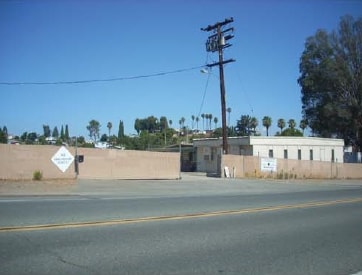
Property Detail
13080 E Highway 8
400-060-08
BLK 17 LOT 15 DOC19-0284819 IN ST CLSD&IN LOT 5 OF BLK 33&IN TR DB0170PG071
Storemultistory
SAN DIEGO
M52
California
B and X Area of moderate flood hazard, usually the area between the limits of the 100-year and 500-year floods.
15,5
2024
0.24 AC
2025
East County
016401
San Diego
4,111 SF
San Diego-Chula Vista-Carlsbad, CA
NEARBY LISTINGS FOR SALE OR LEASE
DEMOGRAPHICS near 13080 E Highway 8
1 mile
3 mile
5 mile
2025 Total Population
12,211
110,718
227,602
2030 Population
12,159
110,821
227,442
Pop Growth 2025-2030
(0.43%)
+ 0.09%
(0.07%)
Average Age
41
39
40
2025 Total Households
4,057
37,235
76,797
HH Growth 2025-2030
(0.59%)
(0.06%)
(0.23%)
Median Household Inc
$112,453
$85,727
$88,310
Avg Household Size
2.90
2.90
2.80
2025 Avg HH Vehicles
2.00
2.00
2.00
Median Home Value
$634,266
$656,739
$707,510
Median Year Built
1977
1976
1976
Nearby Places
Map Layers
Map Styles
 Street
 Aerial
Layers
 Traffic
 Biking
Places
Listings with unknown addresses are not visible on the map
- Restaurants
- Banks
- Shops
- Fitness
- Groceries
PUBLIC TRANSPORTATION
AIRPORT
San Diego International
Drive
Walk
Distance
San Diego International
29 min
21.1 mi
Freight Ports
Port of San Diego
Drive
Walk
Distance
Port of San Diego
28 min
20.0 mi
SALE & LEASE HISTORY
LISTING DATE
SALE/LEASE

Jul 11, 2025
For Lease
Nearby Properties
Address
Land Use
TOTAL SIZE
Lot Size
Zoning
Address
Land Use
TOTAL SIZE
Lot Size
Zoning
8.82 AC
RM-2200
Address
Land Use
TOTAL SIZE
Lot Size
Zoning
6.12 AC
RM-2200
Address
Land Use
TOTAL SIZE
Lot Size
Zoning
5.77 AC
RU
Address
Land Use
TOTAL SIZE
Lot Size
Zoning
9.38 AC
RU
Address
Land Use
TOTAL SIZE
Lot Size
Zoning
64,900 SF
4.55 AC
RM-2200
Address
Land Use
TOTAL SIZE
Lot Size
Zoning
38.80 AC
RMH8
Address
Land Use
TOTAL SIZE
Lot Size
Zoning
5.45 AC
R14
Address
Land Use
TOTAL SIZE
Lot Size
Zoning
4.39 AC
RM-2200
Address
Land Use
TOTAL SIZE
Lot Size
Zoning
3.80 AC
NC/R14
Address
Land Use
TOTAL SIZE
Lot Size
Zoning
4.93 AC
C36
Address
Land Use
TOTAL SIZE
Lot Size
Zoning
4.75 AC
C-6
Address
Land Use
TOTAL SIZE
Lot Size
Zoning
4.69 AC
RU
Address
Land Use
TOTAL SIZE
Lot Size
Zoning
81,896 SF
3.74 AC
RM-2200
Address
Land Use
TOTAL SIZE
Lot Size
Zoning
95,024 SF
2.89 AC
RM-2200
Address
Land Use
TOTAL SIZE
Lot Size
Zoning
3.33 AC
R22
Address
Land Use
TOTAL SIZE
Lot Size
Zoning
70,656 SF
2.67 AC
RM-2200
Address
Land Use
TOTAL SIZE
Lot Size
Zoning
74,882 SF
3.45 AC
RU
Address
Land Use
TOTAL SIZE
Lot Size
Zoning
67,722 SF
3.57 AC
RM-2500
Address
Land Use
TOTAL SIZE
Lot Size
Zoning
2,736 SF
32.31 AC
RS-20
Address
Land Use
TOTAL SIZE
Lot Size
Zoning
5.78 AC
RM-2200
Address
Land Use
TOTAL SIZE
Lot Size
Zoning
14.80 AC
S88
Address
Land Use
TOTAL SIZE
Lot Size
Zoning
56,525 SF
6.29 AC
S88
Address
Land Use
TOTAL SIZE
Lot Size
Zoning
91,916 SF
3.07 AC
RM-2200
Address
Land Use
TOTAL SIZE
Lot Size
Zoning
87,704 SF
3.74 AC
RU
Address
Land Use
TOTAL SIZE
Lot Size
Zoning
17.06 AC
RMH9
Address
Land Use
TOTAL SIZE
Lot Size
Zoning
73,756 SF
3.49 AC
RU
Address
Land Use
TOTAL SIZE
Lot Size
Zoning
81,578 SF
4.95 AC
R14
Address
Land Use
TOTAL SIZE
Lot Size
Zoning
35.63 AC
S88
Address
Land Use
TOTAL SIZE
Lot Size
Zoning
57,840 SF
5.59 AC
R7
Address
Land Use
TOTAL SIZE
Lot Size
Zoning
61,941 SF
4.58 AC
C-N
The World's #1 Commercial Real Estate Marketplace
Connect with us
© 2026 CoStar Group
The information above has been obtained from sources believed reliable. While we do not doubt its accuracy we have not verified it and make no guarantee, warranty or representation about it. It is your responsibility to independently confirm its accuracy and completeness. Any projections, opinions, assumptions, or estimates used are for example only and do not represent the current or future performance of the property. The value of this transaction to you depends on tax and other factors which should be evaluated by your tax, financial, and legal advisors. You and your advisors should conduct a careful, independent investigation of the property to determine to your satisfaction the suitability of the property for your needs.