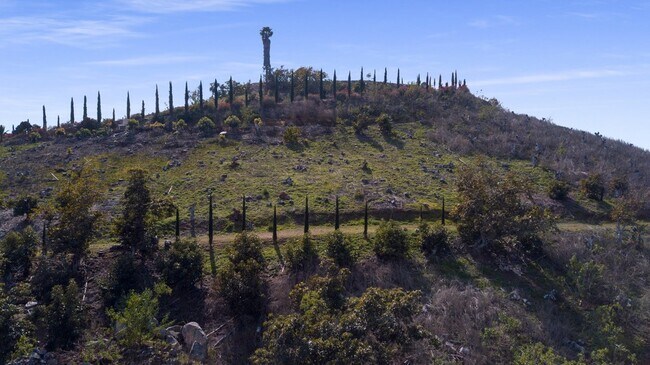
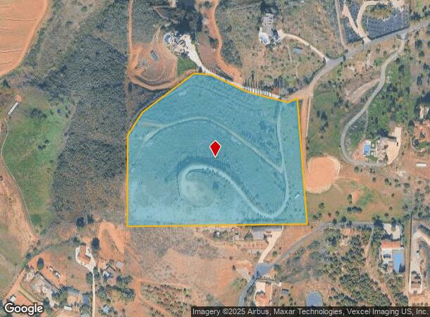
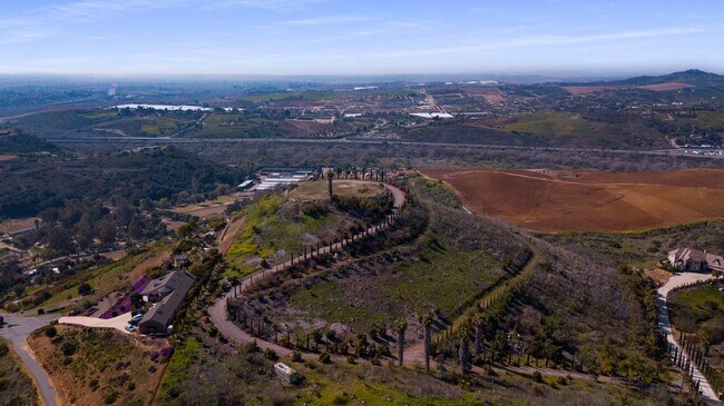
Property Record
1309 Chariot Ct, Bonsall, CA 92003

NEARBY LISTINGS FOR SALE OR LEASE
Property Detail
1309 Chariot Ct
San Diego-Chula Vista-Carlsbad, CA
Parcel Map No 12634
126-180-63
PAR 4 TR PM12634
Agriculturalland
San Diego
X
California
06073C0488G
11.25 AC
2024
Outlying SD County N
2025
San Diego
018803
DEMOGRAPHICS near 1309 Chariot Ct
1 Mile
3 Mile
5 Mile
2024 Total Population
867
18,447
117,357
2029 Population
865
18,239
116,125
Pop Growth 2024-2029
(0.23%)
(1.13%)
(1.05%)
Average Age
47
43
39
2024 Total Households
309
6,222
36,742
HH Growth 2024-2029
(0.32%)
(1.32%)
(1.27%)
Median Household Inc
$110,500
$116,843
$95,713
Avg Household Size
2.80
2.90
3.00
2024 Avg HH Vehicles
3.00
3.00
2.00
Median Home Value
$1,019,286
$824,296
$715,076
Median Year Built
1988
1984
1983
Nearby Places
Map Layers
Map Styles
 Street
 Aerial
- Restaurants
- Banks
- Shops
- Fitness
- Groceries
SALE & LEASE HISTORY
LISTING DATE
SALE/LEASE

Feb 25, 2020
For Sale
Nearby Properties
Address
Land Use
TOTAL SIZE
Lot Size
Zoning
Address
Land Use
TOTAL SIZE
Lot Size
Zoning
21.44 AC
C-1
Address
Land Use
TOTAL SIZE
Lot Size
Zoning
6.87 AC
CN-SP-EQ
Address
Land Use
TOTAL SIZE
Lot Size
Zoning
89,926 SF
4.25 AC
C-1
Address
Land Use
TOTAL SIZE
Lot Size
Zoning
13,878 SF
880.39 AC
A70
Address
Land Use
TOTAL SIZE
Lot Size
Zoning
44,963 SF
43.97 AC
A70
Address
Land Use
TOTAL SIZE
Lot Size
Zoning
11.53 AC
CN-SP-EQ
Address
Land Use
TOTAL SIZE
Lot Size
Zoning
45,150 SF
5.04 AC
SPI
Address
Land Use
TOTAL SIZE
Lot Size
Zoning
39,340 SF
21.40 AC
A70
Address
Land Use
TOTAL SIZE
Lot Size
Zoning
158.28 AC
A
Address
Land Use
TOTAL SIZE
Lot Size
Zoning
29,600 SF
1.51 AC
RU
Address
Land Use
TOTAL SIZE
Lot Size
Zoning
170.70 AC
A
Address
Land Use
TOTAL SIZE
Lot Size
Zoning
81,702 SF
4.40 AC
R-M
Address
Land Use
TOTAL SIZE
Lot Size
Zoning
9.20 AC
A70
Address
Land Use
TOTAL SIZE
Lot Size
Zoning
120 AC
A
Address
Land Use
TOTAL SIZE
Lot Size
Zoning
1,332 SF
112.26 AC
A
Address
Land Use
TOTAL SIZE
Lot Size
Zoning
40,145 SF
110.61 AC
S88
Address
Land Use
TOTAL SIZE
Lot Size
Zoning
38,114 SF
2.85 AC
C36
Address
Land Use
TOTAL SIZE
Lot Size
Zoning
13.98 AC
C-1
Address
Land Use
TOTAL SIZE
Lot Size
Zoning
35.36 AC
A-EQ
Address
Land Use
TOTAL SIZE
Lot Size
Zoning
28,228 SF
1.71 AC
R-M
Address
Land Use
TOTAL SIZE
Lot Size
Zoning
84,375 SF
12.04 AC
C36
Address
Land Use
TOTAL SIZE
Lot Size
Zoning
4.18 AC
A70
Address
Land Use
TOTAL SIZE
Lot Size
Zoning
5,405 SF
0.86 AC
C36
Address
Land Use
TOTAL SIZE
Lot Size
Zoning
51,544 SF
2.53 AC
R-M
Address
Land Use
TOTAL SIZE
Lot Size
Zoning
53,631 SF
19.72 AC
A-EQ
Address
Land Use
TOTAL SIZE
Lot Size
Zoning
49.17 AC
A70
Address
Land Use
TOTAL SIZE
Lot Size
Zoning
78,410 SF
7.41 AC
C36
Address
Land Use
TOTAL SIZE
Lot Size
Zoning
9,595 SF
4.68 AC
RM-A-SP-EQ
Address
Land Use
TOTAL SIZE
Lot Size
Zoning
52.54 AC
A
Address
Land Use
TOTAL SIZE
Lot Size
Zoning
2,589 SF
8.92 AC
A70
The World's #1 Commercial Real Estate Marketplace
Connect with us
© 2026 CoStar Group
The information above has been obtained from sources believed reliable. While we do not doubt its accuracy we have not verified it and make no guarantee, warranty or representation about it. It is your responsibility to independently confirm its accuracy and completeness. Any projections, opinions, assumptions, or estimates used are for example only and do not represent the current or future performance of the property. The value of this transaction to you depends on tax and other factors which should be evaluated by your tax, financial, and legal advisors. You and your advisors should conduct a careful, independent investigation of the property to determine to your satisfaction the suitability of the property for your needs.