Property Record
13090 Preston Rd, Frisco, TX 75033
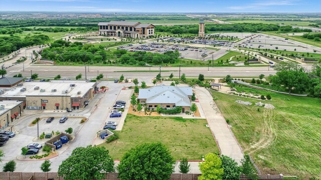


This Property Is For Sale
Property Detail
13090 Preston Rd
Dallas-Fort Worth-Arlington, TX
AOS PANTHER CREEK ADDITION, BLK A, LOT 3
R-11895-00A-0030-1
COLLIN
Officebuilding
Texas
B and X Area of moderate flood hazard, usually the area between the limits of the 100-year and 500-year floods.
3
2025
1.25 AC
2025
Frisco/The Colony
030520
Dallas/Ft Worth
4,980 SF
NEARBY LISTINGS FOR SALE OR LEASE
DEMOGRAPHICS near 13090 Preston Rd
1 mile
3 mile
5 mile
2025 Total Population
9,111
73,512
262,657
2030 Population
10,351
84,330
299,682
Pop Growth 2025-2030
+ 13.61%
+ 14.72%
+ 14.10%
Average Age
36
35
36
2025 Total Households
2,859
23,227
85,494
HH Growth 2025-2030
+ 13.82%
+ 15.02%
+ 14.36%
Median Household Inc
$164,899
$162,203
$158,369
Avg Household Size
3.10
3.10
3.00
2025 Avg HH Vehicles
2.00
2.00
2.00
Median Home Value
$715,708
$671,728
$675,727
Median Year Built
2008
2010
2010
Nearby Places
Map Layers
Map Styles
 Street
 Aerial
Transit
 Traffic
 Biking
Places
Listings with unknown addresses are not visible on the map
- Restaurants
- Banks
- Shops
- Fitness
- Groceries
PUBLIC TRANSPORTATION
AIRPORT
Dallas Love Field
Drive
Walk
Distance
Dallas Love Field
38 min
28.3 mi
Dallas-Fort Worth International
Drive
Walk
Distance
Dallas-Fort Worth International
37 min
28.8 mi
Freight Ports
Port of Shreveport
Drive
Walk
Distance
Port of Shreveport
241 min
221.7 mi
Nearby Properties
Address
Land Use
TOTAL SIZE
Lot Size
Zoning
Address
Land Use
TOTAL SIZE
Lot Size
Zoning
479,244 SF
26.82 AC
COMM
Address
Land Use
TOTAL SIZE
Lot Size
Zoning
343,317 SF
17.17 AC
Address
Land Use
TOTAL SIZE
Lot Size
Zoning
882,734 SF
98.26 AC
Address
Land Use
TOTAL SIZE
Lot Size
Zoning
458,757 SF
83.22 AC
Address
Land Use
TOTAL SIZE
Lot Size
Zoning
489,385 SF
10.24 AC
Address
Land Use
TOTAL SIZE
Lot Size
Zoning
491,094 SF
14.06 AC
Address
Land Use
TOTAL SIZE
Lot Size
Zoning
490,246 SF
24.39 AC
MF-M
Address
Land Use
TOTAL SIZE
Lot Size
Zoning
466,467 SF
46.81 AC
Address
Land Use
TOTAL SIZE
Lot Size
Zoning
151,733 SF
Address
Land Use
TOTAL SIZE
Lot Size
Zoning
236,513 SF
99.95 AC
Address
Land Use
TOTAL SIZE
Lot Size
Zoning
530,080 SF
16.91 AC
Address
Land Use
TOTAL SIZE
Lot Size
Zoning
329,460 SF
63.31 AC
Address
Land Use
TOTAL SIZE
Lot Size
Zoning
352,470 SF
96.59 AC
Address
Land Use
TOTAL SIZE
Lot Size
Zoning
533,937 SF
17.44 AC
MF-M
Address
Land Use
TOTAL SIZE
Lot Size
Zoning
510,032 SF
7.47 AC
Address
Land Use
TOTAL SIZE
Lot Size
Zoning
386,806 SF
22.59 AC
Address
Land Use
TOTAL SIZE
Lot Size
Zoning
516,677 SF
23.69 AC
Address
Land Use
TOTAL SIZE
Lot Size
Zoning
389,116 SF
9.72 AC
Address
Land Use
TOTAL SIZE
Lot Size
Zoning
218,013 SF
32.85 AC
AG
Address
Land Use
TOTAL SIZE
Lot Size
Zoning
536,616 SF
23.21 AC
MF-M
Address
Land Use
TOTAL SIZE
Lot Size
Zoning
334,425 SF
3.83 AC
MF-E
Address
Land Use
TOTAL SIZE
Lot Size
Zoning
360,589 SF
22.99 AC
MU
Address
Land Use
TOTAL SIZE
Lot Size
Zoning
308,202 SF
3.69 AC
Address
Land Use
TOTAL SIZE
Lot Size
Zoning
339,685 SF
13.82 AC
MF
Address
Land Use
TOTAL SIZE
Lot Size
Zoning
352,475 SF
16.80 AC
MF-M
Address
Land Use
TOTAL SIZE
Lot Size
Zoning
380,361 SF
3.24 AC
MU
Address
Land Use
TOTAL SIZE
Lot Size
Zoning
365,199 SF
6.79 AC
Address
Land Use
TOTAL SIZE
Lot Size
Zoning
366,732 SF
4.58 AC
Address
Land Use
TOTAL SIZE
Lot Size
Zoning
309,073 SF
32.96 AC
Address
Land Use
TOTAL SIZE
Lot Size
Zoning
146,061 SF
49.28 AC
NS
The World's #1 Commercial Real Estate Marketplace
Connect with us
© 2026 CoStar Group
The information above has been obtained from sources believed reliable. While we do not doubt its accuracy we have not verified it and make no guarantee, warranty or representation about it. It is your responsibility to independently confirm its accuracy and completeness. Any projections, opinions, assumptions, or estimates used are for example only and do not represent the current or future performance of the property. The value of this transaction to you depends on tax and other factors which should be evaluated by your tax, financial, and legal advisors. You and your advisors should conduct a careful, independent investigation of the property to determine to your satisfaction the suitability of the property for your needs.