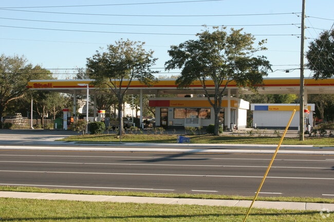
Property Record
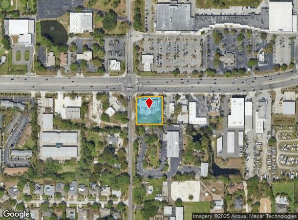
13098 Walsingham Rd, Largo, FL 33774
NEARBY LISTINGS FOR SALE OR LEASE
Property Detail
13098 Walsingham Rd
Tampa-St. Petersburg-Clearwater, FL
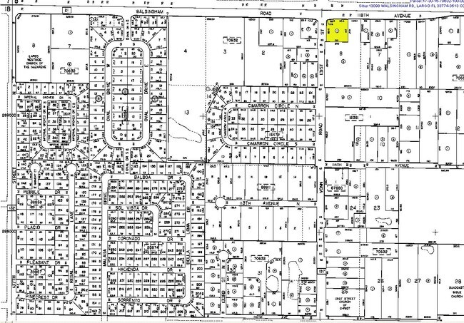
Pinellas Groves
17-30-15-70632-100-0801
PINELLAS GROVES NE 1/4, PT OF LOT 8 BEG NW COR OF NE 1/4 E 225FT S 75 FT FOR POB TH S 197FT TH W 185FT TH N 180.6FT TH N47DE 13.68FT TH N84DE 62.94FT TH N89DE 112.5FT TO POB
Storebuilding
Pinellas
X
Florida
12103C0114H
8
2024
0.83 AC
2025
Mid-Pinellas
025119
Tampa/St Petersburg
1,860 SF
DEMOGRAPHICS near 13098 Walsingham Rd
1 Mile
3 Mile
5 Mile
2024 Total Population
8,923
90,484
189,117
2029 Population
8,965
91,217
191,036
Pop Growth 2024-2029
+ 0.47%
+ 0.81%
+ 1.01%
Average Age
47
49
49
2024 Total Households
4,086
42,184
88,348
HH Growth 2024-2029
+ 0.29%
+ 0.86%
+ 1.03%
Median Household Inc
$62,955
$66,099
$65,224
Avg Household Size
2.10
2.10
2.10
2024 Avg HH Vehicles
2.00
2.00
2.00
Median Home Value
$309,108
$312,872
$299,924
Median Year Built
1975
1974
1975
Nearby Places
Map Layers
Map Styles
 Street
 Aerial
- Restaurants
- Banks
- Shops
- Fitness
- Groceries
PUBLIC TRANSPORTATION
AIRPORT
St Pete-Clearwater International
DRIVE
WALK
Distance
St Pete-Clearwater International
25 min
11.4 mi
Tampa International
DRIVE
WALK
Distance
Tampa International
37 min
22.9 mi
Freight Ports
Port Manatee
DRIVE
WALK
Distance
Port Manatee
58 min
40.9 mi
Nearby Properties
Address
Land Use
TOTAL SIZE
Lot Size
Zoning
Address
Land Use
TOTAL SIZE
Lot Size
Zoning
537,958 SF
41.61 AC
C2
Address
Land Use
TOTAL SIZE
Lot Size
Zoning
372,952 SF
31.56 AC
Address
Land Use
TOTAL SIZE
Lot Size
Zoning
520,871 SF
29 AC
R6
Address
Land Use
TOTAL SIZE
Lot Size
Zoning
367,081 SF
13.80 AC
Address
Land Use
TOTAL SIZE
Lot Size
Zoning
223,748 SF
100.32 AC
R3
Address
Land Use
TOTAL SIZE
Lot Size
Zoning
333,425 SF
33.66 AC
Address
Land Use
TOTAL SIZE
Lot Size
Zoning
318,185 SF
38.78 AC
C2
Address
Land Use
TOTAL SIZE
Lot Size
Zoning
509,129 SF
18.74 AC
Address
Land Use
TOTAL SIZE
Lot Size
Zoning
545,062 SF
8.37 AC
Address
Land Use
TOTAL SIZE
Lot Size
Zoning
294,101 SF
22.55 AC
Address
Land Use
TOTAL SIZE
Lot Size
Zoning
198,688 SF
11.99 AC
Address
Land Use
TOTAL SIZE
Lot Size
Zoning
261,486 SF
30.21 AC
RPD20
Address
Land Use
TOTAL SIZE
Lot Size
Zoning
129,600 SF
7.09 AC
Address
Land Use
TOTAL SIZE
Lot Size
Zoning
267,730 SF
35.84 AC
AE
Address
Land Use
TOTAL SIZE
Lot Size
Zoning
6,098 SF
374.66 AC
AE
Address
Land Use
TOTAL SIZE
Lot Size
Zoning
157,904 SF
0.57 AC
Address
Land Use
TOTAL SIZE
Lot Size
Zoning
186,391 SF
11.86 AC
Address
Land Use
TOTAL SIZE
Lot Size
Zoning
157,769 SF
4.47 AC
Address
Land Use
TOTAL SIZE
Lot Size
Zoning
236,240 SF
12.38 AC
RPD15
Address
Land Use
TOTAL SIZE
Lot Size
Zoning
222,888 SF
11.83 AC
RPD15
Address
Land Use
TOTAL SIZE
Lot Size
Zoning
152,088 SF
92.28 AC
PC
Address
Land Use
TOTAL SIZE
Lot Size
Zoning
133,440 SF
6.85 AC
RM15
Address
Land Use
TOTAL SIZE
Lot Size
Zoning
121,807 SF
17.23 AC
Address
Land Use
TOTAL SIZE
Lot Size
Zoning
102,073 SF
9.07 AC
Address
Land Use
TOTAL SIZE
Lot Size
Zoning
160,134 SF
18.61 AC
R2
Address
Land Use
TOTAL SIZE
Lot Size
Zoning
69,001 SF
2.26 AC
Address
Land Use
TOTAL SIZE
Lot Size
Zoning
147,755 SF
6.86 AC
Address
Land Use
TOTAL SIZE
Lot Size
Zoning
95,997 SF
13.61 AC
RM15
Address
Land Use
TOTAL SIZE
Lot Size
Zoning
167,424 SF
17.30 AC
RM1
Address
Land Use
TOTAL SIZE
Lot Size
Zoning
110,192 SF
4.58 AC
The World's #1 Commercial Real Estate Marketplace
Connect with us
© 2025 CoStar Group
The information above has been obtained from sources believed reliable. While we do not doubt its accuracy we have not verified it and make no guarantee, warranty or representation about it. It is your responsibility to independently confirm its accuracy and completeness. Any projections, opinions, assumptions, or estimates used are for example only and do not represent the current or future performance of the property. The value of this transaction to you depends on tax and other factors which should be evaluated by your tax, financial, and legal advisors. You and your advisors should conduct a careful, independent investigation of the property to determine to your satisfaction the suitability of the property for your needs.