Property Record
131 Barclay Dr, Stamford, CT 06903
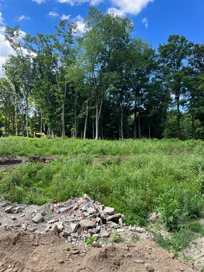
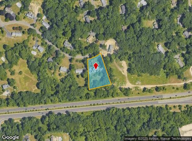
This Property Is For Sale
NEARBY LISTINGS FOR SALE OR LEASE
-
-
View all Stamford listings for sale on LoopNet.com
Property Detail
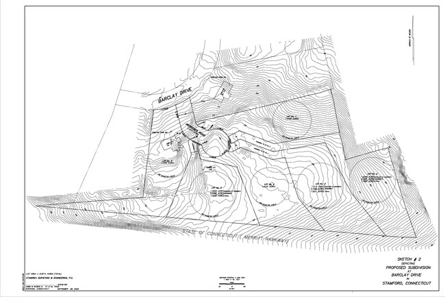
131 Barclay Dr
Bridgeport-Stamford-Norwalk, CT
Fairfield
STAM-000001-000000-009848
Connecticut
Sfr
1.10 AC
X
Stamford
09001C0502F
Westchester/So Connecticut
2,002 SF
DEMOGRAPHICS near 131 Barclay Dr
1 Mile
3 Mile
5 Mile
2024 Total Population
3,754
45,596
181,440
2029 Population
3,774
45,806
182,667
Pop Growth 2024-2029
+ 0.53%
+ 0.46%
+ 0.68%
Average Age
45
42
39
2024 Total Households
1,311
16,486
68,990
HH Growth 2024-2029
+ 0.38%
+ 0.44%
+ 0.88%
Median Household Inc
$182,788
$153,069
$117,487
Avg Household Size
2.70
2.70
2.50
2024 Avg HH Vehicles
2.00
2.00
2.00
Median Home Value
$802,615
$734,537
$773,448
Median Year Built
1964
1963
1971
Nearby Places
- Restaurants
- Banks
- Shops
- Fitness
- Groceries
PUBLIC TRANSPORTATION
COMMUTER RAIL
DRIVE
WALK
Distance
16 min
5.6 mi
Glenbrook Station (New Haven Line - Metro-North Commuter Railroad Company (Metro-North))
DRIVE
WALK
Distance
Glenbrook Station (New Haven Line - Metro-North Commuter Railroad Company (Metro-North))
15 min
5.7 mi
AIRPORT
Westchester County
DRIVE
WALK
Distance
Westchester County
23 min
13.0 mi
LaGuardia
DRIVE
WALK
Distance
LaGuardia
57 min
35.8 mi
Freight Ports
Port of New Haven
DRIVE
WALK
Distance
Port of New Haven
64 min
43.4 mi
Nearby Properties
Address
Land Use
TOTAL SIZE
Lot Size
Zoning
Address
Land Use
TOTAL SIZE
Lot Size
Zoning
13.21 AC
CSCD
Address
Land Use
TOTAL SIZE
Lot Size
Zoning
98,106 SF
42.71 AC
RA-2
Address
Land Use
TOTAL SIZE
Lot Size
Zoning
32.43 AC
RA1
Address
Land Use
TOTAL SIZE
Lot Size
Zoning
25.91 AC
MZN
Address
Land Use
TOTAL SIZE
Lot Size
Zoning
29.87 AC
R10
Address
Land Use
TOTAL SIZE
Lot Size
Zoning
26.11 AC
CN
Address
Land Use
TOTAL SIZE
Lot Size
Zoning
75,531 SF
6.85 AC
MZN
Address
Land Use
TOTAL SIZE
Lot Size
Zoning
277,836 SF
2.17 AC
CB
Address
Land Use
TOTAL SIZE
Lot Size
Zoning
34.05 AC
RA1
Address
Land Use
TOTAL SIZE
Lot Size
Zoning
16.99 AC
CD
Address
Land Use
TOTAL SIZE
Lot Size
Zoning
28.54 AC
R20
Address
Land Use
TOTAL SIZE
Lot Size
Zoning
23.84 AC
CD
Address
Land Use
TOTAL SIZE
Lot Size
Zoning
219,634 SF
10 AC
CD
Address
Land Use
TOTAL SIZE
Lot Size
Zoning
7.84 AC
BD
Address
Land Use
TOTAL SIZE
Lot Size
Zoning
196,860 SF
CN
Address
Land Use
TOTAL SIZE
Lot Size
Zoning
40.46 AC
RA2
Address
Land Use
TOTAL SIZE
Lot Size
Zoning
3,705 SF
158.41 AC
RA-2
Address
Land Use
TOTAL SIZE
Lot Size
Zoning
160,203 SF
12.38 AC
MZN
Address
Land Use
TOTAL SIZE
Lot Size
Zoning
16.96 AC
R20
Address
Land Use
TOTAL SIZE
Lot Size
Zoning
90,690 SF
12.80 AC
R20
Address
Land Use
TOTAL SIZE
Lot Size
Zoning
8.79 AC
R10
Address
Land Use
TOTAL SIZE
Lot Size
Zoning
36.58 AC
CD
Address
Land Use
TOTAL SIZE
Lot Size
Zoning
14.07 AC
CD
Address
Land Use
TOTAL SIZE
Lot Size
Zoning
3.50 AC
CN
Address
Land Use
TOTAL SIZE
Lot Size
Zoning
12.22 AC
RA1
Address
Land Use
TOTAL SIZE
Lot Size
Zoning
15 AC
CD
Address
Land Use
TOTAL SIZE
Lot Size
Zoning
8,337 SF
132.50 AC
P
Address
Land Use
TOTAL SIZE
Lot Size
Zoning
48.10 AC
P
Address
Land Use
TOTAL SIZE
Lot Size
Zoning
87,525 SF
16.87 AC
RA1
Address
Land Use
TOTAL SIZE
Lot Size
Zoning
69,558 SF
10 AC
RD
The World's #1 Commercial Real Estate Marketplace
Connect with us
© 2025 CoStar Group
The information above has been obtained from sources believed reliable. While we do not doubt its accuracy we have not verified it and make no guarantee, warranty or representation about it. It is your responsibility to independently confirm its accuracy and completeness. Any projections, opinions, assumptions, or estimates used are for example only and do not represent the current or future performance of the property. The value of this transaction to you depends on tax and other factors which should be evaluated by your tax, financial, and legal advisors. You and your advisors should conduct a careful, independent investigation of the property to determine to your satisfaction the suitability of the property for your needs.