Property Record
131 E Crest Rd, Bessemer, AL 35023
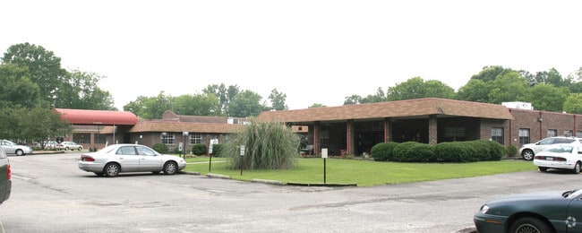

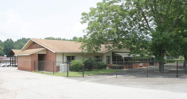
Property Detail
131 E Crest Rd
30-00-19-1-005-018.001
POB 264 FT N OF SW COR OF SE 1/4 OF NE 1/4 SEC 19 TWP 18 R 4 CONT N 355 FT TH SE 305 FT TH S 317.8 FT W 303 FT TO POB
Medicalbuilding
Jefferson
B-2
Alabama
B and X Area of moderate flood hazard, usually the area between the limits of the 100-year and 500-year floods.
2 AC
2024
Bessemer
2025
Birmingham
010001
Birmingham, AL
30,332 SF
NEARBY LISTINGS FOR SALE OR LEASE
-
-
View all Bessemer listings for sale on LoopNet.com
DEMOGRAPHICS near 131 E Crest Rd
1 mile
3 mile
5 mile
2025 Total Population
5,193
24,851
63,160
2030 Population
5,084
24,417
62,917
Pop Growth 2025-2030
(2.10%)
(1.75%)
(0.38%)
Average Age
40
41
41
2025 Total Households
2,008
9,644
24,734
HH Growth 2025-2030
(2.29%)
(1.79%)
(0.43%)
Median Household Inc
$46,918
$60,225
$53,665
Avg Household Size
2.40
2.50
2.40
2025 Avg HH Vehicles
2.00
2.00
2.00
Median Home Value
$152,007
$170,448
$156,297
Median Year Built
1976
1971
1968
Nearby Places
Map Layers
Map Styles
 Street
 Aerial
Layers
 Traffic
 Biking
Places
Listings with unknown addresses are not visible on the map
- Restaurants
- Banks
- Shops
- Fitness
- Groceries
PUBLIC TRANSPORTATION
AIRPORT
Birmingham-Shuttlesworth International
Drive
Walk
Distance
Birmingham-Shuttlesworth International
26 min
18.4 mi
Nearby Properties
Address
Land Use
TOTAL SIZE
Lot Size
Zoning
Address
Land Use
TOTAL SIZE
Lot Size
Zoning
2,573,547 SF
112 AC
I2
Address
Land Use
TOTAL SIZE
Lot Size
Zoning
1,244,986 SF
I2
Address
Land Use
TOTAL SIZE
Lot Size
Zoning
195,495 SF
29 AC
B3
Address
Land Use
TOTAL SIZE
Lot Size
Zoning
460,483 SF
20 AC
I3
Address
Land Use
TOTAL SIZE
Lot Size
Zoning
219,210 SF
19 AC
M2
Address
Land Use
TOTAL SIZE
Lot Size
Zoning
230,088 SF
I3
Address
Land Use
TOTAL SIZE
Lot Size
Zoning
130,563 SF
I3
Address
Land Use
TOTAL SIZE
Lot Size
Zoning
66,928 SF
3.10 AC
B2-R
Address
Land Use
TOTAL SIZE
Lot Size
Zoning
77,902 SF
44 AC
I3
Address
Land Use
TOTAL SIZE
Lot Size
Zoning
58,822 SF
7.80 AC
B3
Address
Land Use
TOTAL SIZE
Lot Size
Zoning
69,344 SF
2 AC
B-1
Address
Land Use
TOTAL SIZE
Lot Size
Zoning
1,200 SF
14 AC
R3
Address
Land Use
TOTAL SIZE
Lot Size
Zoning
1,437,077 SF
I2
Address
Land Use
TOTAL SIZE
Lot Size
Zoning
80,043 SF
11 AC
B3-C
Address
Land Use
TOTAL SIZE
Lot Size
Zoning
163,056 SF
I-3
Address
Land Use
TOTAL SIZE
Lot Size
Zoning
49,022 SF
5.50 AC
R2
Address
Land Use
TOTAL SIZE
Lot Size
Zoning
80,220 SF
7 AC
M2
Address
Land Use
TOTAL SIZE
Lot Size
Zoning
65,232 SF
4 AC
R-5
Address
Land Use
TOTAL SIZE
Lot Size
Zoning
32,606 SF
2 AC
B2-R
Address
Land Use
TOTAL SIZE
Lot Size
Zoning
92,532 SF
127 AC
I3
Address
Land Use
TOTAL SIZE
Lot Size
Zoning
59,554 SF
1.37 AC
R2
Address
Land Use
TOTAL SIZE
Lot Size
Zoning
52,810 SF
3 AC
B-3
Address
Land Use
TOTAL SIZE
Lot Size
Zoning
62,918 SF
4 AC
R2-R
Address
Land Use
TOTAL SIZE
Lot Size
Zoning
109,004 SF
I3
Address
Land Use
TOTAL SIZE
Lot Size
Zoning
47,232 SF
1 AC
B2-R
Address
Land Use
TOTAL SIZE
Lot Size
Zoning
34,491 SF
6 AC
B2-M
Address
Land Use
TOTAL SIZE
Lot Size
Zoning
46,844 SF
2 AC
R-5
Address
Land Use
TOTAL SIZE
Lot Size
Zoning
66,935 SF
2 AC
B2
Address
Land Use
TOTAL SIZE
Lot Size
Zoning
77,154 SF
23.20 AC
I2
The World's #1 Commercial Real Estate Marketplace
Connect with us
© 2026 CoStar Group
The information above has been obtained from sources believed reliable. While we do not doubt its accuracy we have not verified it and make no guarantee, warranty or representation about it. It is your responsibility to independently confirm its accuracy and completeness. Any projections, opinions, assumptions, or estimates used are for example only and do not represent the current or future performance of the property. The value of this transaction to you depends on tax and other factors which should be evaluated by your tax, financial, and legal advisors. You and your advisors should conduct a careful, independent investigation of the property to determine to your satisfaction the suitability of the property for your needs.