Property Record
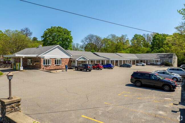
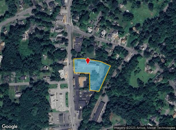
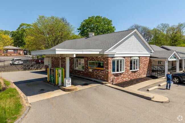
131 Main St, Lancaster, MA 01523
NEARBY LISTINGS FOR SALE OR LEASE
-
-
View all Lancaster listings for lease on LoopNet.com
Property Detail
131 Main St
LANC-000410-000000-002360
Worcester
Regionalshoppingcenterormallwithanchorstore
Massachusetts
X
236.0
25027C0458F
1.50 AC
2025
Outlying Worcester
2025
Boston
713100
Worcester, MA
10,274 SF
DEMOGRAPHICS near 131 Main St
1 Mile
3 Mile
5 Mile
2024 Total Population
4,048
23,684
37,438
2029 Population
4,008
23,571
37,317
Pop Growth 2024-2029
(0.99%)
(0.48%)
(0.32%)
Average Age
42
41
42
2024 Total Households
1,621
9,462
14,548
HH Growth 2024-2029
(1.05%)
(0.52%)
(0.37%)
Median Household Inc
$90,285
$92,111
$98,489
Avg Household Size
2.50
2.40
2.50
2024 Avg HH Vehicles
2.00
2.00
2.00
Median Home Value
$368,629
$385,669
$409,713
Median Year Built
1955
1959
1968
Nearby Places
Map Layers
Map Styles
 Street
 Aerial
- Restaurants
- Banks
- Shops
- Fitness
- Groceries
PUBLIC TRANSPORTATION
COMMUTER RAIL
North Leominster (Fitchburg/South Acton Line - Massachusetts Bay Transportation Authority Commuter Rail (Purple Line))
DRIVE
WALK
Distance
North Leominster (Fitchburg/South Acton Line - Massachusetts Bay Transportation Authority Commuter Rail (Purple Line))
17 min
9.1 mi
AIRPORT
Worcester Regional
DRIVE
WALK
Distance
Worcester Regional
38 min
19.8 mi
Freight Ports
Port of Boston
DRIVE
WALK
Distance
Port of Boston
67 min
48.7 mi
SALE & LEASE HISTORY
LISTING DATE
SALE/LEASE

Mar 11, 2019
For Lease
Feb 24, 2023
For Lease
Nearby Properties
Address
Land Use
TOTAL SIZE
Lot Size
Zoning
Address
Land Use
TOTAL SIZE
Lot Size
Zoning
26.80 AC
Address
Land Use
TOTAL SIZE
Lot Size
Zoning
344,000 SF
20.63 AC
Address
Land Use
TOTAL SIZE
Lot Size
Zoning
168,653 SF
6.50 AC
Address
Land Use
TOTAL SIZE
Lot Size
Zoning
455,636 SF
54.47 AC
Address
Land Use
TOTAL SIZE
Lot Size
Zoning
85,557 SF
9.27 AC
Address
Land Use
TOTAL SIZE
Lot Size
Zoning
64,497 SF
3.27 AC
Address
Land Use
TOTAL SIZE
Lot Size
Zoning
8.46 AC
Address
Land Use
TOTAL SIZE
Lot Size
Zoning
128,324 SF
1.03 AC
Address
Land Use
TOTAL SIZE
Lot Size
Zoning
174,412 SF
Address
Land Use
TOTAL SIZE
Lot Size
Zoning
12.69 AC
Address
Land Use
TOTAL SIZE
Lot Size
Zoning
2.37 AC
Address
Land Use
TOTAL SIZE
Lot Size
Zoning
147,092 SF
36.90 AC
Address
Land Use
TOTAL SIZE
Lot Size
Zoning
16,504 SF
0.45 AC
Address
Land Use
TOTAL SIZE
Lot Size
Zoning
5,050 SF
11.92 AC
Address
Land Use
TOTAL SIZE
Lot Size
Zoning
2.07 AC
Address
Land Use
TOTAL SIZE
Lot Size
Zoning
4,536 SF
48.38 AC
Address
Land Use
TOTAL SIZE
Lot Size
Zoning
158,900 SF
80 AC
Address
Land Use
TOTAL SIZE
Lot Size
Zoning
48,240 SF
0.59 AC
Address
Land Use
TOTAL SIZE
Lot Size
Zoning
116,116 SF
53.90 AC
Address
Land Use
TOTAL SIZE
Lot Size
Zoning
133,068 SF
9 AC
Address
Land Use
TOTAL SIZE
Lot Size
Zoning
1.61 AC
Address
Land Use
TOTAL SIZE
Lot Size
Zoning
884 SF
59.40 AC
R1
Address
Land Use
TOTAL SIZE
Lot Size
Zoning
33,050 SF
7.80 AC
Address
Land Use
TOTAL SIZE
Lot Size
Zoning
70,516 SF
23 AC
Address
Land Use
TOTAL SIZE
Lot Size
Zoning
12.66 AC
Address
Land Use
TOTAL SIZE
Lot Size
Zoning
201,446 SF
47.61 AC
R1
Address
Land Use
TOTAL SIZE
Lot Size
Zoning
0.01 AC
Address
Land Use
TOTAL SIZE
Lot Size
Zoning
7,344 SF
Address
Land Use
TOTAL SIZE
Lot Size
Zoning
26,939 SF
0.75 AC
Address
Land Use
TOTAL SIZE
Lot Size
Zoning
1.81 AC
The World's #1 Commercial Real Estate Marketplace
Connect with us
© 2026 CoStar Group
The information above has been obtained from sources believed reliable. While we do not doubt its accuracy we have not verified it and make no guarantee, warranty or representation about it. It is your responsibility to independently confirm its accuracy and completeness. Any projections, opinions, assumptions, or estimates used are for example only and do not represent the current or future performance of the property. The value of this transaction to you depends on tax and other factors which should be evaluated by your tax, financial, and legal advisors. You and your advisors should conduct a careful, independent investigation of the property to determine to your satisfaction the suitability of the property for your needs.