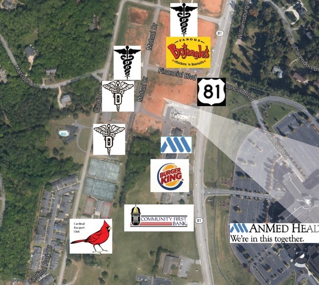
Property Record
131 Mutual Dr, Anderson, SC 29621
Property Detail
131 Mutual Dr
Greenville-Anderson-Greer, SC
CP 000/000 PP S 1735/4+5 D114 D137 PP S 1731/9+10 PT LT 8 MUTUAL DR .42 AC
147-08-01-058
Anderson
Commercialacreage
South Carolina
B and X Area of moderate flood hazard, usually the area between the limits of the 100-year and 500-year floods.
8
2024
0.42 AC
2024
Anderson County
001100
Greenville/Spartanburg
NEARBY LISTINGS FOR SALE OR LEASE
DEMOGRAPHICS near 131 Mutual Dr
1 mile
3 mile
5 mile
2024 Total Population
5,385
36,077
70,221
2029 Population
5,664
37,896
74,094
Pop Growth 2024-2029
+ 5.18%
+ 5.04%
+ 5.52%
Average Age
43
40
40
2024 Total Households
2,068
13,995
28,045
HH Growth 2024-2029
+ 5.03%
+ 5.08%
+ 5.66%
Median Household Inc
$80,654
$69,812
$58,964
Avg Household Size
2.40
2.40
2.40
2024 Avg HH Vehicles
2.00
2.00
2.00
Median Home Value
$339,932
$291,488
$254,285
Median Year Built
1995
1987
1984
Nearby Places
Map Layers
Map Styles
 Street
 Aerial
Transit
 Traffic
 Biking
Places
Listings with unknown addresses are not visible on the map
- Restaurants
- Banks
- Shops
- Fitness
- Groceries
PUBLIC TRANSPORTATION
AIRPORT
Greenville Spartanburg International
Drive
Walk
Distance
Greenville Spartanburg International
51 min
37.4 mi
SALE & LEASE HISTORY
LISTING DATE
SALE/LEASE

Dec 16, 2016
For Sale
Nearby Properties
Address
Land Use
TOTAL SIZE
Lot Size
Zoning
Address
Land Use
TOTAL SIZE
Lot Size
Zoning
17,286 SF
19.71 AC
Address
Land Use
TOTAL SIZE
Lot Size
Zoning
66,400 SF
12 AC
Address
Land Use
TOTAL SIZE
Lot Size
Zoning
2,778 SF
12.37 AC
Address
Land Use
TOTAL SIZE
Lot Size
Zoning
15,168 SF
11.99 AC
Address
Land Use
TOTAL SIZE
Lot Size
Zoning
1,210 SF
16.52 AC
Address
Land Use
TOTAL SIZE
Lot Size
Zoning
7,568 SF
10.99 AC
Address
Land Use
TOTAL SIZE
Lot Size
Zoning
118,242 SF
10.63 AC
Address
Land Use
TOTAL SIZE
Lot Size
Zoning
71,276 SF
4.07 AC
Address
Land Use
TOTAL SIZE
Lot Size
Zoning
1,475 SF
9.65 AC
Address
Land Use
TOTAL SIZE
Lot Size
Zoning
1,328 SF
8.79 AC
Address
Land Use
TOTAL SIZE
Lot Size
Zoning
121,900 SF
11.39 AC
Address
Land Use
TOTAL SIZE
Lot Size
Zoning
729 SF
10 AC
Address
Land Use
TOTAL SIZE
Lot Size
Zoning
53,002 SF
15.97 AC
Address
Land Use
TOTAL SIZE
Lot Size
Zoning
188,745 SF
20.01 AC
Address
Land Use
TOTAL SIZE
Lot Size
Zoning
87,670 SF
5.81 AC
Address
Land Use
TOTAL SIZE
Lot Size
Zoning
135,174 SF
27.88 AC
Address
Land Use
TOTAL SIZE
Lot Size
Zoning
42,416 SF
6.45 AC
Address
Land Use
TOTAL SIZE
Lot Size
Zoning
134,827 SF
14.32 AC
Address
Land Use
TOTAL SIZE
Lot Size
Zoning
40,071 SF
18.83 AC
Address
Land Use
TOTAL SIZE
Lot Size
Zoning
27,372 SF
2.49 AC
Address
Land Use
TOTAL SIZE
Lot Size
Zoning
1,983 SF
14.26 AC
Address
Land Use
TOTAL SIZE
Lot Size
Zoning
25,908 SF
12.50 AC
Address
Land Use
TOTAL SIZE
Lot Size
Zoning
49,123 SF
5.14 AC
Address
Land Use
TOTAL SIZE
Lot Size
Zoning
33,173 SF
4.59 AC
Address
Land Use
TOTAL SIZE
Lot Size
Zoning
91,698 SF
10.04 AC
Address
Land Use
TOTAL SIZE
Lot Size
Zoning
67,563 SF
17.23 AC
Address
Land Use
TOTAL SIZE
Lot Size
Zoning
71,500 SF
11.88 AC
Address
Land Use
TOTAL SIZE
Lot Size
Zoning
31,616 SF
4.99 AC
Address
Land Use
TOTAL SIZE
Lot Size
Zoning
101,818 SF
11.78 AC
The World's #1 Commercial Real Estate Marketplace
Connect with us
© 2026 CoStar Group
The information above has been obtained from sources believed reliable. While we do not doubt its accuracy we have not verified it and make no guarantee, warranty or representation about it. It is your responsibility to independently confirm its accuracy and completeness. Any projections, opinions, assumptions, or estimates used are for example only and do not represent the current or future performance of the property. The value of this transaction to you depends on tax and other factors which should be evaluated by your tax, financial, and legal advisors. You and your advisors should conduct a careful, independent investigation of the property to determine to your satisfaction the suitability of the property for your needs.