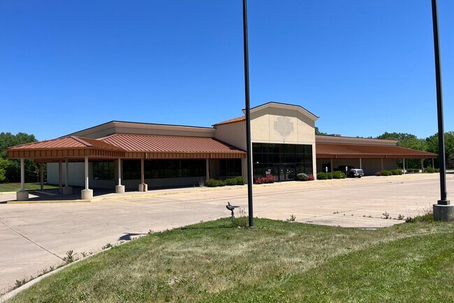
Property Record
131 S Soangetaha Rd, Galesburg, IL 61401
NEARBY LISTINGS FOR SALE OR LEASE
Property Detail
131 S Soangetaha Rd
Galesburg, IL
Lake Washington Sub
99-13-229-014
SD 1904 NE SEC 13 T11 R1 W100' OF .60 AC IN NE COR LOT 5 S OF HWY & NELY 50.23' OF LOT 19 IN LAKE WASHINGTON SUB LOTS 19 & 20
Commercialnec
Knox
X
Illinois
17095C0279E
5,19
2024
2.66 AC
2024
Illinois North Area
000600
Other Market Areas
DEMOGRAPHICS near 131 S Soangetaha Rd
1 Mile
3 Mile
5 Mile
2024 Total Population
2,634
22,509
33,762
2029 Population
2,538
21,880
32,685
Pop Growth 2024-2029
(3.64%)
(2.79%)
(3.19%)
Average Age
41
41
42
2024 Total Households
1,141
9,537
14,052
HH Growth 2024-2029
(3.77%)
(3.05%)
(3.47%)
Median Household Inc
$44,885
$40,765
$41,898
Avg Household Size
2.20
2.10
2.10
2024 Avg HH Vehicles
2.00
2.00
2.00
Median Home Value
$71,035
$68,609
$80,124
Median Year Built
1961
1949
1954
Nearby Places
Map Layers
Map Styles
 Street
 Aerial
- Restaurants
- Banks
- Shops
- Fitness
- Groceries
PUBLIC TRANSPORTATION
COMMUTER RAIL
DRIVE
WALK
Distance
4 min
2.2 mi
SALE & LEASE HISTORY
LISTING DATE
SALE/LEASE

Oct 03, 2023
For Sale
May 25, 2022
For Sale
Nearby Properties
Address
Land Use
TOTAL SIZE
Lot Size
Zoning
Address
Land Use
TOTAL SIZE
Lot Size
Zoning
26.16 AC
Address
Land Use
TOTAL SIZE
Lot Size
Zoning
3.47 AC
Address
Land Use
TOTAL SIZE
Lot Size
Zoning
4.82 AC
Address
Land Use
TOTAL SIZE
Lot Size
Zoning
22.76 AC
Address
Land Use
TOTAL SIZE
Lot Size
Zoning
Address
Land Use
TOTAL SIZE
Lot Size
Zoning
10,963 SF
18.98 AC
Address
Land Use
TOTAL SIZE
Lot Size
Zoning
13.46 AC
Address
Land Use
TOTAL SIZE
Lot Size
Zoning
103.55 AC
Address
Land Use
TOTAL SIZE
Lot Size
Zoning
Address
Land Use
TOTAL SIZE
Lot Size
Zoning
Address
Land Use
TOTAL SIZE
Lot Size
Zoning
Address
Land Use
TOTAL SIZE
Lot Size
Zoning
1.43 AC
Address
Land Use
TOTAL SIZE
Lot Size
Zoning
1.65 AC
Address
Land Use
TOTAL SIZE
Lot Size
Zoning
11.50 AC
Address
Land Use
TOTAL SIZE
Lot Size
Zoning
2.30 AC
Address
Land Use
TOTAL SIZE
Lot Size
Zoning
Address
Land Use
TOTAL SIZE
Lot Size
Zoning
9,928 SF
1.36 AC
Address
Land Use
TOTAL SIZE
Lot Size
Zoning
4.98 AC
Address
Land Use
TOTAL SIZE
Lot Size
Zoning
1.06 AC
Address
Land Use
TOTAL SIZE
Lot Size
Zoning
Address
Land Use
TOTAL SIZE
Lot Size
Zoning
2.76 AC
Address
Land Use
TOTAL SIZE
Lot Size
Zoning
9.83 AC
Address
Land Use
TOTAL SIZE
Lot Size
Zoning
Address
Land Use
TOTAL SIZE
Lot Size
Zoning
10.89 AC
Address
Land Use
TOTAL SIZE
Lot Size
Zoning
Address
Land Use
TOTAL SIZE
Lot Size
Zoning
1.39 AC
Address
Land Use
TOTAL SIZE
Lot Size
Zoning
0.43 AC
Address
Land Use
TOTAL SIZE
Lot Size
Zoning
0.81 AC
Address
Land Use
TOTAL SIZE
Lot Size
Zoning
The World's #1 Commercial Real Estate Marketplace
Connect with us
© 2026 CoStar Group
The information above has been obtained from sources believed reliable. While we do not doubt its accuracy we have not verified it and make no guarantee, warranty or representation about it. It is your responsibility to independently confirm its accuracy and completeness. Any projections, opinions, assumptions, or estimates used are for example only and do not represent the current or future performance of the property. The value of this transaction to you depends on tax and other factors which should be evaluated by your tax, financial, and legal advisors. You and your advisors should conduct a careful, independent investigation of the property to determine to your satisfaction the suitability of the property for your needs.