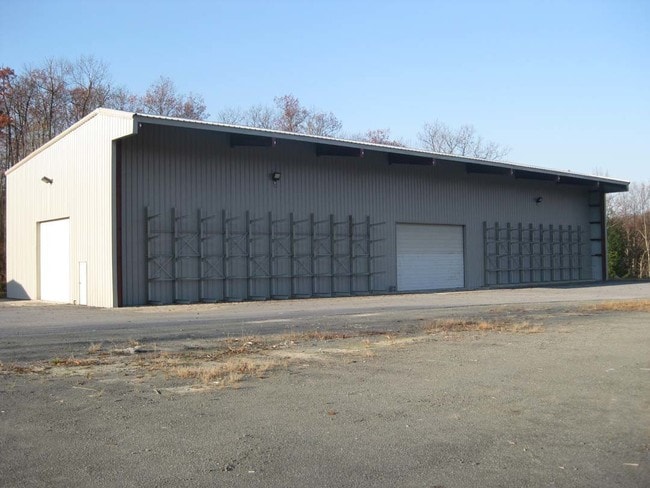
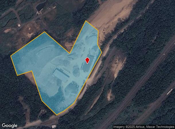
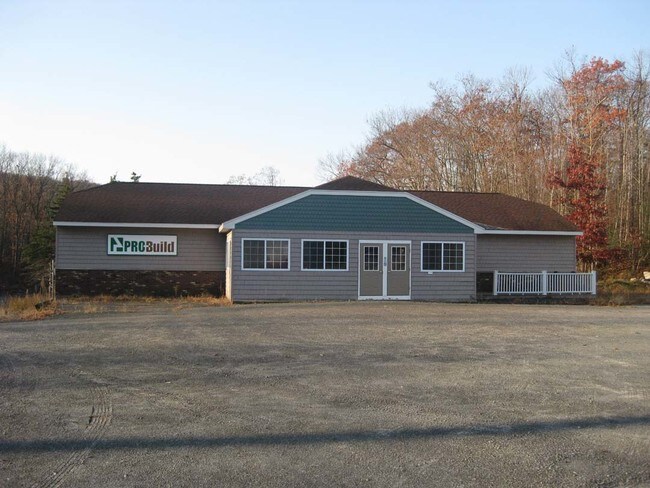
Property Record
131 Us Highway 6, Port Jervis, NY 12771

NEARBY LISTINGS FOR SALE OR LEASE
Property Detail
131 Us Highway 6
332800-057-000-0001-096.000-0000
Orange
Miningfacilityoilgasmineralpreciousmetals
New York
X
96.00
34037C0035E
10.60 AC
2024
Orange County
2024
Northern New Jersey
011601
Kiryas Joel-Poughkeepsie-Newburgh, NY
21,132 SF
DEMOGRAPHICS near 131 Us Highway 6
1 Mile
3 Mile
5 Mile
2024 Total Population
588
15,222
21,545
2029 Population
611
15,664
22,109
Pop Growth 2024-2029
+ 3.91%
+ 2.90%
+ 2.62%
Average Age
43
42
42
2024 Total Households
223
6,170
8,638
HH Growth 2024-2029
+ 3.59%
+ 3.05%
+ 2.80%
Median Household Inc
$97,265
$58,029
$64,945
Avg Household Size
2.60
2.40
2.40
2024 Avg HH Vehicles
2.00
2.00
2.00
Median Home Value
$266,922
$206,876
$226,669
Median Year Built
1984
1957
1967
Nearby Places
Map Layers
Map Styles
 Street
 Aerial
- Restaurants
- Banks
- Shops
- Fitness
- Groceries
PUBLIC TRANSPORTATION
COMMUTER RAIL
Port Jervis (Bergen County/Port Jervis Line - NJ Transit Commuter Rail (NJ Transit), Main/Port Jervis Line - NJ Transit Commuter Rail (NJ Transit))
DRIVE
WALK
Distance
Port Jervis (Bergen County/Port Jervis Line - NJ Transit Commuter Rail (NJ Transit), Main/Port Jervis Line - NJ Transit Commuter Rail (NJ Transit))
7 min
3.3 mi
AIRPORT
New York Stewart International
DRIVE
WALK
Distance
New York Stewart International
45 min
34.7 mi
Freight Ports
Maher Terminal
DRIVE
WALK
Distance
Maher Terminal
103 min
69.9 mi
SALE & LEASE HISTORY
LISTING DATE
SALE/LEASE

Jun 06, 2018
For Lease
Apr 09, 2018
For Sale
Nearby Properties
Address
Land Use
TOTAL SIZE
Lot Size
Zoning
Address
Land Use
TOTAL SIZE
Lot Size
Zoning
4.40 AC
NMU
Address
Land Use
TOTAL SIZE
Lot Size
Zoning
1,664 SF
1.10 AC
R2
Address
Land Use
TOTAL SIZE
Lot Size
Zoning
4.30 AC
07
Address
Land Use
TOTAL SIZE
Lot Size
Zoning
16.92 AC
C2
Address
Land Use
TOTAL SIZE
Lot Size
Zoning
49.20 AC
Address
Land Use
TOTAL SIZE
Lot Size
Zoning
53,580 SF
7.80 AC
Address
Land Use
TOTAL SIZE
Lot Size
Zoning
14,077 SF
2.20 AC
MCD
Address
Land Use
TOTAL SIZE
Lot Size
Zoning
Address
Land Use
TOTAL SIZE
Lot Size
Zoning
4.10 AC
R2
Address
Land Use
TOTAL SIZE
Lot Size
Zoning
3,030 SF
10.50 AC
Address
Land Use
TOTAL SIZE
Lot Size
Zoning
3,030 SF
13.84 AC
Address
Land Use
TOTAL SIZE
Lot Size
Zoning
53,254 SF
4.10 AC
SCAH
Address
Land Use
TOTAL SIZE
Lot Size
Zoning
14,226 SF
503.20 AC
RP
Address
Land Use
TOTAL SIZE
Lot Size
Zoning
20,914 SF
1.10 AC
NMU
Address
Land Use
TOTAL SIZE
Lot Size
Zoning
97,962 SF
8.90 AC
CBD
Address
Land Use
TOTAL SIZE
Lot Size
Zoning
56,864 SF
2.54 AC
Address
Land Use
TOTAL SIZE
Lot Size
Zoning
102,497 SF
3.90 AC
LI
Address
Land Use
TOTAL SIZE
Lot Size
Zoning
1 AC
C2
Address
Land Use
TOTAL SIZE
Lot Size
Zoning
3.50 AC
C2
Address
Land Use
TOTAL SIZE
Lot Size
Zoning
3.48 AC
C-2
Address
Land Use
TOTAL SIZE
Lot Size
Zoning
72,575 SF
7.26 AC
Address
Land Use
TOTAL SIZE
Lot Size
Zoning
49.70 AC
BT
Address
Land Use
TOTAL SIZE
Lot Size
Zoning
25,042 SF
2.10 AC
07
Address
Land Use
TOTAL SIZE
Lot Size
Zoning
3,007 SF
59.03 AC
R-1
Address
Land Use
TOTAL SIZE
Lot Size
Zoning
28,725 SF
1.40 AC
NMU
Address
Land Use
TOTAL SIZE
Lot Size
Zoning
21.10 AC
R1
Address
Land Use
TOTAL SIZE
Lot Size
Zoning
87,263 SF
10.78 AC
Address
Land Use
TOTAL SIZE
Lot Size
Zoning
73,625 SF
3.60 AC
LI
Address
Land Use
TOTAL SIZE
Lot Size
Zoning
77,935 SF
50.77 AC
Address
Land Use
TOTAL SIZE
Lot Size
Zoning
142.92 AC
R-5
The World's #1 Commercial Real Estate Marketplace
Connect with us
© 2026 CoStar Group
The information above has been obtained from sources believed reliable. While we do not doubt its accuracy we have not verified it and make no guarantee, warranty or representation about it. It is your responsibility to independently confirm its accuracy and completeness. Any projections, opinions, assumptions, or estimates used are for example only and do not represent the current or future performance of the property. The value of this transaction to you depends on tax and other factors which should be evaluated by your tax, financial, and legal advisors. You and your advisors should conduct a careful, independent investigation of the property to determine to your satisfaction the suitability of the property for your needs.