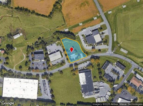
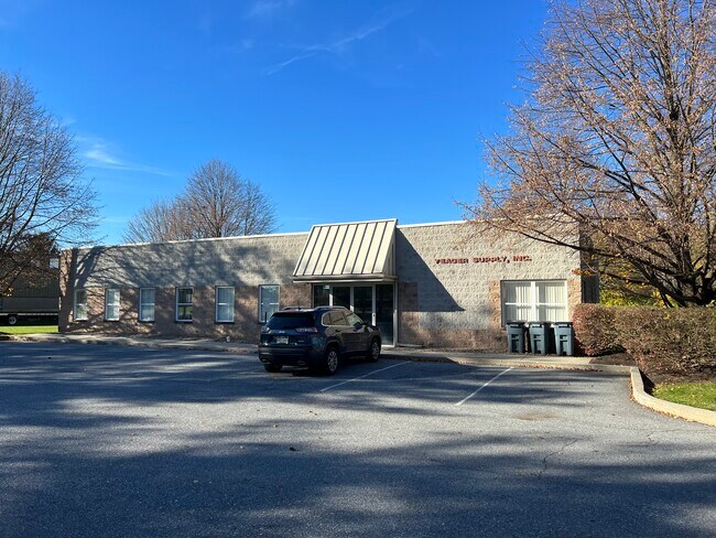
Property Record
131 W Airport Rd, Lititz, PA 17543

NEARBY LISTINGS FOR SALE OR LEASE
Property Detail
131 W Airport Rd
390-07430-0-0000
131 W AIRPORT RD
Lightindustrial
Lancaster
AE
Pennsylvania
42071C0356F
10
2024
1.21 AC
2025
Lancaster County
011901
Philadelphia
4,000 SF
Lancaster, PA
DEMOGRAPHICS near 131 W Airport Rd
1 Mile
3 Mile
5 Mile
2024 Total Population
6,863
50,914
111,070
2029 Population
7,160
51,649
112,174
Pop Growth 2024-2029
+ 4.33%
+ 1.44%
+ 0.99%
Average Age
53
45
43
2024 Total Households
2,236
19,490
42,872
HH Growth 2024-2029
+ 5.90%
+ 1.55%
+ 0.97%
Median Household Inc
$84,316
$90,279
$86,444
Avg Household Size
2.50
2.40
2.50
2024 Avg HH Vehicles
2.00
2.00
2.00
Median Home Value
$357,403
$291,141
$278,822
Median Year Built
1998
1983
1979
Nearby Places
Map Layers
Map Styles
 Street
 Aerial
- Restaurants
- Banks
- Shops
- Fitness
- Groceries
PUBLIC TRANSPORTATION
COMMUTER RAIL
Lancaster (Keystone Service - Amtrak, Pennsylvanian - Amtrak)
DRIVE
WALK
Distance
Lancaster (Keystone Service - Amtrak, Pennsylvanian - Amtrak)
7 min
4.9 mi
AIRPORT
Harrisburg International
DRIVE
WALK
Distance
Harrisburg International
42 min
31.2 mi
Freight Ports
Port of Wilmington, RI
DRIVE
WALK
Distance
Port of Wilmington, RI
99 min
57.9 mi
SALE & LEASE HISTORY
LISTING DATE
SALE/LEASE

Nov 09, 2022
For Sale
Jun 27, 2023
For Lease
Nearby Properties
Address
Land Use
TOTAL SIZE
Lot Size
Zoning
Address
Land Use
TOTAL SIZE
Lot Size
Zoning
1,070,497 SF
149.62 AC
Address
Land Use
TOTAL SIZE
Lot Size
Zoning
822,447 SF
77.29 AC
Address
Land Use
TOTAL SIZE
Lot Size
Zoning
740,990 SF
106.29 AC
Address
Land Use
TOTAL SIZE
Lot Size
Zoning
678,995 SF
96.17 AC
Address
Land Use
TOTAL SIZE
Lot Size
Zoning
259,035 SF
744.42 AC
Address
Land Use
TOTAL SIZE
Lot Size
Zoning
4,290 SF
35.80 AC
R-1
Address
Land Use
TOTAL SIZE
Lot Size
Zoning
185,924 SF
43.71 AC
I2
Address
Land Use
TOTAL SIZE
Lot Size
Zoning
233,738 SF
34.10 AC
Address
Land Use
TOTAL SIZE
Lot Size
Zoning
354,921 SF
6.36 AC
Address
Land Use
TOTAL SIZE
Lot Size
Zoning
283,042 SF
17.50 AC
Address
Land Use
TOTAL SIZE
Lot Size
Zoning
200,090 SF
Address
Land Use
TOTAL SIZE
Lot Size
Zoning
173,138 SF
36.20 AC
R-2
Address
Land Use
TOTAL SIZE
Lot Size
Zoning
213,584 SF
3.80 AC
CC
Address
Land Use
TOTAL SIZE
Lot Size
Zoning
148,187 SF
40 AC
R-1
Address
Land Use
TOTAL SIZE
Lot Size
Zoning
174,149 SF
0.22 AC
Address
Land Use
TOTAL SIZE
Lot Size
Zoning
210,312 SF
25.89 AC
R-2
Address
Land Use
TOTAL SIZE
Lot Size
Zoning
89,662 SF
18.40 AC
R-1
Address
Land Use
TOTAL SIZE
Lot Size
Zoning
98,000 SF
18.30 AC
R-1
Address
Land Use
TOTAL SIZE
Lot Size
Zoning
10 SF
26.30 AC
I-2
Address
Land Use
TOTAL SIZE
Lot Size
Zoning
205,692 SF
19.79 AC
R-3
Address
Land Use
TOTAL SIZE
Lot Size
Zoning
111,061 SF
4.90 AC
Address
Land Use
TOTAL SIZE
Lot Size
Zoning
88,535 SF
2.46 AC
R-2
Address
Land Use
TOTAL SIZE
Lot Size
Zoning
80,125 SF
19.27 AC
Address
Land Use
TOTAL SIZE
Lot Size
Zoning
112,382 SF
3.10 AC
I
Address
Land Use
TOTAL SIZE
Lot Size
Zoning
128,516 SF
20.40 AC
R2
Address
Land Use
TOTAL SIZE
Lot Size
Zoning
96,836 SF
11.47 AC
R-1
Address
Land Use
TOTAL SIZE
Lot Size
Zoning
78,660 SF
39.30 AC
Address
Land Use
TOTAL SIZE
Lot Size
Zoning
54,494 SF
39.98 AC
Address
Land Use
TOTAL SIZE
Lot Size
Zoning
23,314 SF
106.31 AC
Address
Land Use
TOTAL SIZE
Lot Size
Zoning
103,118 SF
17.29 AC
The World's #1 Commercial Real Estate Marketplace
Connect with us
© 2025 CoStar Group
The information above has been obtained from sources believed reliable. While we do not doubt its accuracy we have not verified it and make no guarantee, warranty or representation about it. It is your responsibility to independently confirm its accuracy and completeness. Any projections, opinions, assumptions, or estimates used are for example only and do not represent the current or future performance of the property. The value of this transaction to you depends on tax and other factors which should be evaluated by your tax, financial, and legal advisors. You and your advisors should conduct a careful, independent investigation of the property to determine to your satisfaction the suitability of the property for your needs.