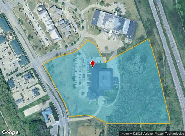
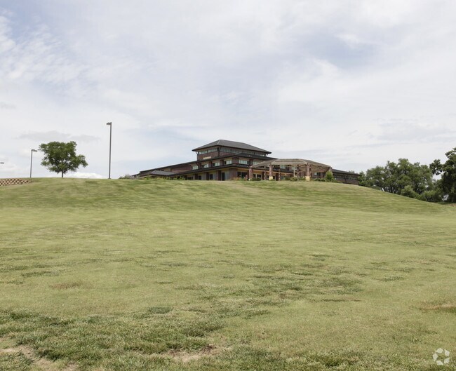
Property Record
131 W Grand Dr, Lincoln, NE 68521

NEARBY LISTINGS FOR SALE OR LEASE
Property Detail
131 W Grand Dr
Lincoln, NE
Highland Coalition 3Rd Addition
11-03-212-001-000
HIGHLAND COALITION 3RD ADDITION, LOT 1
Commercialnec
Lancaster
X
Nebraska
31109C0305F
1
2024
16.29 AC
2025
North Central
003102
Lincoln
56,887 SF
DEMOGRAPHICS near 131 W Grand Dr
1 Mile
3 Mile
5 Mile
2024 Total Population
9,159
47,750
130,146
2029 Population
9,449
49,570
135,225
Pop Growth 2024-2029
+ 3.17%
+ 3.81%
+ 3.90%
Average Age
34
34
34
2024 Total Households
3,714
17,834
52,780
HH Growth 2024-2029
+ 3.18%
+ 3.99%
+ 4.18%
Median Household Inc
$59,952
$56,824
$47,426
Avg Household Size
2.40
2.50
2.30
2024 Avg HH Vehicles
2.00
2.00
2.00
Median Home Value
$233,200
$217,709
$178,113
Median Year Built
1994
1995
1977
Nearby Places
Map Layers
Map Styles
 Street
 Aerial
- Restaurants
- Banks
- Shops
- Fitness
- Groceries
PUBLIC TRANSPORTATION
COMMUTER RAIL
Lincoln Amtrak Station (California Zephyr - Amtrak)
DRIVE
WALK
Distance
Lincoln Amtrak Station (California Zephyr - Amtrak)
7 min
4.7 mi
AIRPORT
Lincoln
DRIVE
WALK
Distance
Lincoln
8 min
4.2 mi
Freight Ports
Tulsa Port Of Catoosa
DRIVE
WALK
Distance
Tulsa Port Of Catoosa
478 min
403.1 mi
Nearby Properties
Address
Land Use
TOTAL SIZE
Lot Size
Zoning
Address
Land Use
TOTAL SIZE
Lot Size
Zoning
30,018 SF
100.37 AC
R3
Address
Land Use
TOTAL SIZE
Lot Size
Zoning
35,233 SF
28.52 AC
NULL
Address
Land Use
TOTAL SIZE
Lot Size
Zoning
708,074 SF
66.04 AC
I1
Address
Land Use
TOTAL SIZE
Lot Size
Zoning
48,088 SF
28.06 AC
R5
Address
Land Use
TOTAL SIZE
Lot Size
Zoning
27,171 SF
14.68 AC
NULL
Address
Land Use
TOTAL SIZE
Lot Size
Zoning
35,422 SF
10.79 AC
R3
Address
Land Use
TOTAL SIZE
Lot Size
Zoning
56,867 SF
22.10 AC
NULL
Address
Land Use
TOTAL SIZE
Lot Size
Zoning
32,110 SF
9.64 AC
B2
Address
Land Use
TOTAL SIZE
Lot Size
Zoning
22,552 SF
16.68 AC
NULL
Address
Land Use
TOTAL SIZE
Lot Size
Zoning
41,456 SF
4.95 AC
B2
Address
Land Use
TOTAL SIZE
Lot Size
Zoning
8,824 SF
12.33 AC
R5
Address
Land Use
TOTAL SIZE
Lot Size
Zoning
65,967 SF
11.65 AC
NULL
Address
Land Use
TOTAL SIZE
Lot Size
Zoning
523.53 AC
I1
Address
Land Use
TOTAL SIZE
Lot Size
Zoning
63,914 SF
12.22 AC
R5
Address
Land Use
TOTAL SIZE
Lot Size
Zoning
141,120 SF
21 AC
O3
Address
Land Use
TOTAL SIZE
Lot Size
Zoning
63,003 SF
1.22 AC
O3
Address
Land Use
TOTAL SIZE
Lot Size
Zoning
228,960 SF
11.04 AC
I2
Address
Land Use
TOTAL SIZE
Lot Size
Zoning
38,769 SF
11.81 AC
NULL
Address
Land Use
TOTAL SIZE
Lot Size
Zoning
317,607 SF
20.81 AC
I2
Address
Land Use
TOTAL SIZE
Lot Size
Zoning
51,994 SF
4.64 AC
O3
Address
Land Use
TOTAL SIZE
Lot Size
Zoning
405,207 SF
29.97 AC
I2
Address
Land Use
TOTAL SIZE
Lot Size
Zoning
72,775 SF
12.16 AC
I2
Address
Land Use
TOTAL SIZE
Lot Size
Zoning
283,600 SF
46.07 AC
I2
Address
Land Use
TOTAL SIZE
Lot Size
Zoning
360,422 SF
23.53 AC
B5
Address
Land Use
TOTAL SIZE
Lot Size
Zoning
152,292 SF
20.28 AC
O3
Address
Land Use
TOTAL SIZE
Lot Size
Zoning
111,645 SF
2.32 AC
R8
Address
Land Use
TOTAL SIZE
Lot Size
Zoning
53,234 SF
5.01 AC
B2
Address
Land Use
TOTAL SIZE
Lot Size
Zoning
73,010 SF
9.67 AC
R3
Address
Land Use
TOTAL SIZE
Lot Size
Zoning
2,077,879 SF
219.88 AC
I2
The World's #1 Commercial Real Estate Marketplace
Connect with us
© 2025 CoStar Group
The information above has been obtained from sources believed reliable. While we do not doubt its accuracy we have not verified it and make no guarantee, warranty or representation about it. It is your responsibility to independently confirm its accuracy and completeness. Any projections, opinions, assumptions, or estimates used are for example only and do not represent the current or future performance of the property. The value of this transaction to you depends on tax and other factors which should be evaluated by your tax, financial, and legal advisors. You and your advisors should conduct a careful, independent investigation of the property to determine to your satisfaction the suitability of the property for your needs.