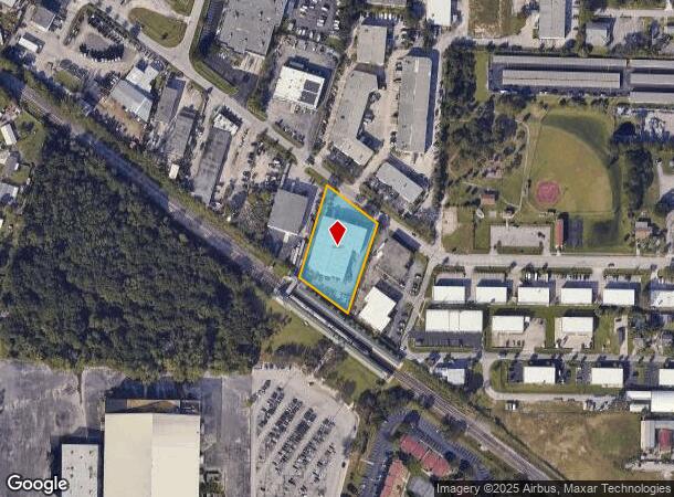
Property Record
1310 53Rd St, Mangonia Park, FL 33407

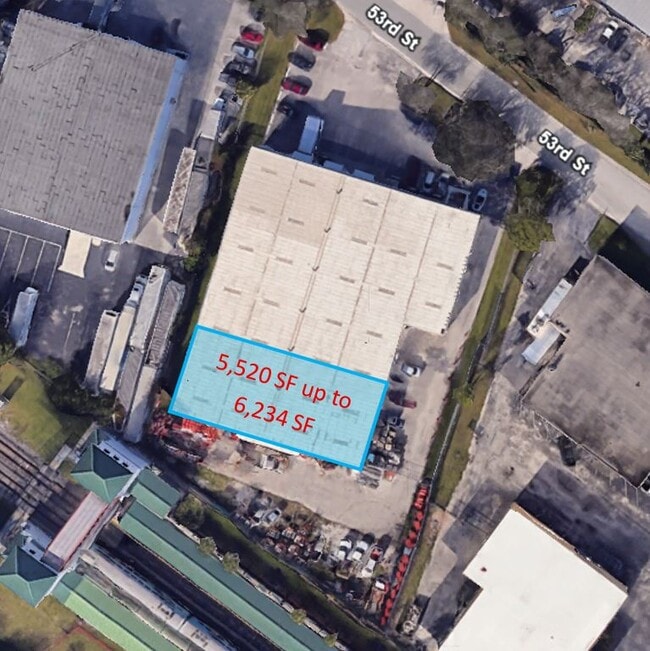

Current Lease Availabilities
NEARBY LISTINGS FOR SALE OR LEASE
Property Detail
1310 53Rd St
West Palm Beach-Boca Raton-Delray Beach, FL
Acreage & Unrec
44-43-43-05-00-014-0040
5-43-43~ WLY 189.39 FT OF ELY 383.91 FT OF SLY 304.3 FT OF TH PT OF GOV LT 14 LYG N OF SAL RY R/W
Warehouse
Palm Beach
X
Florida
12099C0389F
14
2024
1.27 AC
2024
Austin Park/Hill/53rd
001402
South Florida
22,788 SF
DEMOGRAPHICS near 1310 53Rd St
1 Mile
3 Mile
5 Mile
2024 Total Population
9,630
115,176
229,835
2029 Population
10,339
120,846
241,526
Pop Growth 2024-2029
+ 7.36%
+ 4.92%
+ 5.09%
Average Age
34
38
42
2024 Total Households
3,020
43,406
96,512
HH Growth 2024-2029
+ 6.92%
+ 4.38%
+ 4.92%
Median Household Inc
$40,548
$52,716
$57,424
Avg Household Size
3.00
2.50
2.20
2024 Avg HH Vehicles
1.00
1.00
1.00
Median Home Value
$189,374
$253,524
$297,270
Median Year Built
1980
1984
1982
Nearby Places
- Restaurants
- Banks
- Shops
- Fitness
- Groceries
PUBLIC TRANSPORTATION
COMMUTER RAIL
Mangonia Park (Tri-County Commuter - South Florida Regional Transportation Authority (Tri-Rail))
DRIVE
WALK
Distance
Mangonia Park (Tri-County Commuter - South Florida Regional Transportation Authority (Tri-Rail))
1 min
3 min
0.1 mi
West Palm Beach (Tri-County Commuter - South Florida Regional Transportation Authority (Tri-Rail))
DRIVE
WALK
Distance
West Palm Beach (Tri-County Commuter - South Florida Regional Transportation Authority (Tri-Rail))
8 min
3.9 mi
AIRPORT
Palm Beach International
DRIVE
WALK
Distance
Palm Beach International
16 min
7.5 mi
Freight Ports
Port of Palm Beach
DRIVE
WALK
Distance
Port of Palm Beach
7 min
2.6 mi
Nearby Properties
Address
Land Use
TOTAL SIZE
Lot Size
Zoning
Address
Land Use
TOTAL SIZE
Lot Size
Zoning
1,778,741 SF
69.19 AC
CF
Address
Land Use
TOTAL SIZE
Lot Size
Zoning
492,288 SF
58.52 AC
CPD
Address
Land Use
TOTAL SIZE
Lot Size
Zoning
746,972 SF
5.11 AC
CMPD
Address
Land Use
TOTAL SIZE
Lot Size
Zoning
596,079 SF
21.49 AC
RPD
Address
Land Use
TOTAL SIZE
Lot Size
Zoning
31,761 SF
2.26 AC
R-A
Address
Land Use
TOTAL SIZE
Lot Size
Zoning
303,776 SF
27.67 AC
CPD
Address
Land Use
TOTAL SIZE
Lot Size
Zoning
586,386 SF
19.67 AC
RPD
Address
Land Use
TOTAL SIZE
Lot Size
Zoning
546,847 SF
19.50 AC
RPD
Address
Land Use
TOTAL SIZE
Lot Size
Zoning
739,813 SF
81.18 AC
CSPD
Address
Land Use
TOTAL SIZE
Lot Size
Zoning
292,706 SF
30.75 AC
RPD
Address
Land Use
TOTAL SIZE
Lot Size
Zoning
411,080 SF
7.59 AC
CPD
Address
Land Use
TOTAL SIZE
Lot Size
Zoning
416,171 SF
19.24 AC
R-PUD
Address
Land Use
TOTAL SIZE
Lot Size
Zoning
224,212 SF
141.33 AC
CSPD
Address
Land Use
TOTAL SIZE
Lot Size
Zoning
739,127 SF
12.88 AC
CSPD
Address
Land Use
TOTAL SIZE
Lot Size
Zoning
23.07 AC
CLIC
Address
Land Use
TOTAL SIZE
Lot Size
Zoning
232,751 SF
12.67 AC
RPD
Address
Land Use
TOTAL SIZE
Lot Size
Zoning
247,028 SF
14.30 AC
RS
Address
Land Use
TOTAL SIZE
Lot Size
Zoning
433,243 SF
40.26 AC
RM-15
Address
Land Use
TOTAL SIZE
Lot Size
Zoning
307,554 SF
6.10 AC
CSPD
Address
Land Use
TOTAL SIZE
Lot Size
Zoning
314,993 SF
38.46 AC
CF
Address
Land Use
TOTAL SIZE
Lot Size
Zoning
416,165 SF
42.48 AC
CSPD
Address
Land Use
TOTAL SIZE
Lot Size
Zoning
5.81 AC
CMPD
Address
Land Use
TOTAL SIZE
Lot Size
Zoning
108,077 SF
9.72 AC
IG
Address
Land Use
TOTAL SIZE
Lot Size
Zoning
161,206 SF
1.87 AC
POR/PD
Address
Land Use
TOTAL SIZE
Lot Size
Zoning
248,196 SF
8.74 AC
RPD
Address
Land Use
TOTAL SIZE
Lot Size
Zoning
12,062 SF
1.54 AC
R-A
Address
Land Use
TOTAL SIZE
Lot Size
Zoning
0.51 AC
R-B
Address
Land Use
TOTAL SIZE
Lot Size
Zoning
7,705 SF
1.24 AC
R-A
Address
Land Use
TOTAL SIZE
Lot Size
Zoning
185,929 SF
7.56 AC
POR/PD
Address
Land Use
TOTAL SIZE
Lot Size
Zoning
96,953 SF
1.61 AC
C
The World's #1 Commercial Real Estate Marketplace
Connect with us
© 2025 CoStar Group
The information above has been obtained from sources believed reliable. While we do not doubt its accuracy we have not verified it and make no guarantee, warranty or representation about it. It is your responsibility to independently confirm its accuracy and completeness. Any projections, opinions, assumptions, or estimates used are for example only and do not represent the current or future performance of the property. The value of this transaction to you depends on tax and other factors which should be evaluated by your tax, financial, and legal advisors. You and your advisors should conduct a careful, independent investigation of the property to determine to your satisfaction the suitability of the property for your needs.