Property Record
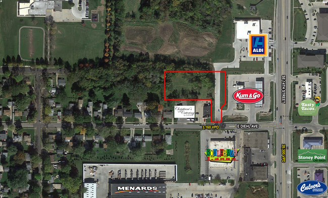
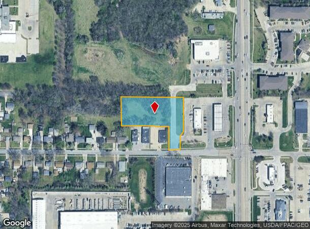
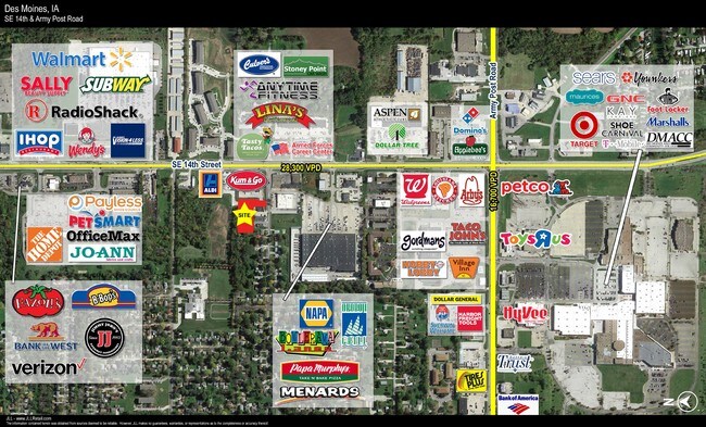
1310 E Diehl Ave, Des Moines, IA 50320
This Property Is For Sale
NEARBY LISTINGS FOR SALE OR LEASE
Property Detail
1310 E Diehl Ave
Des Moines-West Des Moines, IA
Sec 27-78-24
120-07207004000
PARCEL H BK 13755 PG 292 -EX LYG N OF BOWLARAMA PLACE- BEG 349.39F W OF E 1/4 COR SEC 27-78-24 THN S 199.21F SW 31.86F S 78.15F TO N LN E DIEHL AVE SW 64.77F N 135.47F TO N LN BOWLARAMA PLACE W 275.37F N 170.47F E 360.43F TO POB LOT 2 BOWLARAMA PLACE
Miscellaneous
Polk
X
Iowa
19153C0365F
2
2024
1.63 AC
2025
South
010805
Des Moines
1,389 SF
DEMOGRAPHICS near 1310 E Diehl Ave
1 Mile
3 Mile
5 Mile
2024 Total Population
9,425
60,083
109,591
2029 Population
9,805
62,302
114,658
Pop Growth 2024-2029
+ 4.03%
+ 3.69%
+ 4.62%
Average Age
37
37
37
2024 Total Households
3,570
23,445
46,418
HH Growth 2024-2029
+ 4.20%
+ 3.91%
+ 4.95%
Median Household Inc
$51,871
$61,394
$57,016
Avg Household Size
2.50
2.50
2.30
2024 Avg HH Vehicles
2.00
2.00
2.00
Median Home Value
$141,985
$160,595
$164,203
Median Year Built
1975
1972
1973
Nearby Places
- Restaurants
- Banks
- Shops
- Fitness
- Groceries
PUBLIC TRANSPORTATION
AIRPORT
Des Moines International
DRIVE
WALK
Distance
Des Moines International
10 min
4.4 mi
Freight Ports
Port Milwaukee
DRIVE
WALK
Distance
Port Milwaukee
420 min
376.5 mi
Nearby Properties
Address
Land Use
TOTAL SIZE
Lot Size
Zoning
Address
Land Use
TOTAL SIZE
Lot Size
Zoning
208,456 SF
14.42 AC
PUD
Address
Land Use
TOTAL SIZE
Lot Size
Zoning
231,168 SF
22.29 AC
PUD
Address
Land Use
TOTAL SIZE
Lot Size
Zoning
260,420 SF
18.17 AC
R-3
Address
Land Use
TOTAL SIZE
Lot Size
Zoning
178,415 SF
13.35 AC
R-6
Address
Land Use
TOTAL SIZE
Lot Size
Zoning
160,680 SF
20.08 AC
C-2
Address
Land Use
TOTAL SIZE
Lot Size
Zoning
684,064 SF
2 AC
C-3
Address
Land Use
TOTAL SIZE
Lot Size
Zoning
155,640 SF
9.15 AC
R-6
Address
Land Use
TOTAL SIZE
Lot Size
Zoning
138,490 SF
10.01 AC
R-6
Address
Land Use
TOTAL SIZE
Lot Size
Zoning
51,965 SF
3.83 AC
C-4
Address
Land Use
TOTAL SIZE
Lot Size
Zoning
169,201 SF
13.66 AC
C-4
Address
Land Use
TOTAL SIZE
Lot Size
Zoning
82,044 SF
2.91 AC
Address
Land Use
TOTAL SIZE
Lot Size
Zoning
147,173 SF
20.84 AC
PUD
Address
Land Use
TOTAL SIZE
Lot Size
Zoning
58,366 SF
11.58 AC
Address
Land Use
TOTAL SIZE
Lot Size
Zoning
301,434 SF
29.03 AC
C4
Address
Land Use
TOTAL SIZE
Lot Size
Zoning
121,200 SF
10.32 AC
C-2
Address
Land Use
TOTAL SIZE
Lot Size
Zoning
178,721 SF
8.19 AC
C-2
Address
Land Use
TOTAL SIZE
Lot Size
Zoning
73,000 SF
4.07 AC
PUD
Address
Land Use
TOTAL SIZE
Lot Size
Zoning
310,851 SF
18.05 AC
C-4
Address
Land Use
TOTAL SIZE
Lot Size
Zoning
91,166 SF
C-4
Address
Land Use
TOTAL SIZE
Lot Size
Zoning
92,232 SF
6.01 AC
R-3
Address
Land Use
TOTAL SIZE
Lot Size
Zoning
110,260 SF
9.56 AC
PUD
Address
Land Use
TOTAL SIZE
Lot Size
Zoning
73,860 SF
2.52 AC
Address
Land Use
TOTAL SIZE
Lot Size
Zoning
74,600 SF
8.50 AC
Address
Land Use
TOTAL SIZE
Lot Size
Zoning
86,304 SF
3.56 AC
R-3
Address
Land Use
TOTAL SIZE
Lot Size
Zoning
147,400 SF
15.05 AC
C-2
Address
Land Use
TOTAL SIZE
Lot Size
Zoning
50,969 SF
4.64 AC
R-2
Address
Land Use
TOTAL SIZE
Lot Size
Zoning
102,532 SF
10.71 AC
C-2
Address
Land Use
TOTAL SIZE
Lot Size
Zoning
53,192 SF
143.35 AC
R180
Address
Land Use
TOTAL SIZE
Lot Size
Zoning
64,004 SF
5.22 AC
C-4
The World's #1 Commercial Real Estate Marketplace
Connect with us
© 2025 CoStar Group
The information above has been obtained from sources believed reliable. While we do not doubt its accuracy we have not verified it and make no guarantee, warranty or representation about it. It is your responsibility to independently confirm its accuracy and completeness. Any projections, opinions, assumptions, or estimates used are for example only and do not represent the current or future performance of the property. The value of this transaction to you depends on tax and other factors which should be evaluated by your tax, financial, and legal advisors. You and your advisors should conduct a careful, independent investigation of the property to determine to your satisfaction the suitability of the property for your needs.