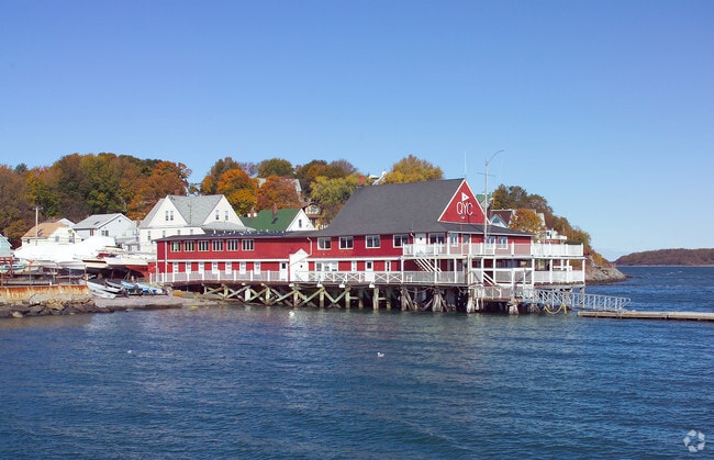
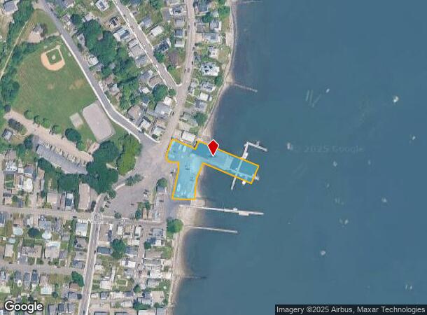
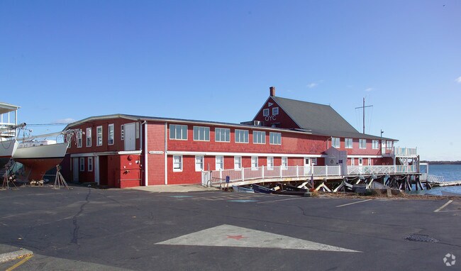
Property Record
1310 Sea St, Quincy, MA 02169
NEARBY LISTINGS FOR SALE OR LEASE
Property Detail
1310 Sea St
Marinafacility
Norfolk
AE
Massachusetts
25021C0089F
1.36 AC
2025
Quincy/Braintree
2025
Boston
417801
Boston-Cambridge-Newton, MA-NH
12,316 SF
QUIN-001005-000000-000020
DEMOGRAPHICS near 1310 Sea St
1 Mile
3 Mile
5 Mile
2024 Total Population
3,822
46,295
178,060
2029 Population
3,797
46,162
177,522
Pop Growth 2024-2029
(0.65%)
(0.29%)
(0.30%)
Average Age
43
43
42
2024 Total Households
1,556
20,449
75,395
HH Growth 2024-2029
(0.77%)
(0.24%)
(0.26%)
Median Household Inc
$104,397
$86,328
$97,551
Avg Household Size
2.40
2.20
2.30
2024 Avg HH Vehicles
2.00
1.00
2.00
Median Home Value
$482,407
$525,877
$606,928
Median Year Built
1946
1960
1956
Nearby Places
Map Layers
Map Styles
 Street
 Aerial
- Restaurants
- Banks
- Shops
- Fitness
- Groceries
PUBLIC TRANSPORTATION
COMMUTER RAIL
Quincy Center Station (Greenbush Line - Massachusetts Bay Transportation Authority Commuter Rail (Purple Line), Kingston/Plymouth Line - Massachusetts Bay Transportation Authority Commuter Rail (Purple Line), Middleborough/Lakeville Line - Massachusetts Bay Transportation Authority Commuter Rail (Purple Line), Red Line - Massachusetts Bay Transportation Authority Commuter Rail (Purple Line))
DRIVE
WALK
Distance
Quincy Center Station (Greenbush Line - Massachusetts Bay Transportation Authority Commuter Rail (Purple Line), Kingston/Plymouth Line - Massachusetts Bay Transportation Authority Commuter Rail (Purple Line), Middleborough/Lakeville Line - Massachusetts Bay Transportation Authority Commuter Rail (Purple Line), Red Line - Massachusetts Bay Transportation Authority Commuter Rail (Purple Line))
8 min
3.8 mi
West Hingham (Greenbush Line - Massachusetts Bay Transportation Authority Commuter Rail (Purple Line))
DRIVE
WALK
Distance
West Hingham (Greenbush Line - Massachusetts Bay Transportation Authority Commuter Rail (Purple Line))
18 min
8.7 mi
AIRPORT
General Edward Lawrence Logan International
DRIVE
WALK
Distance
General Edward Lawrence Logan International
27 min
14.5 mi
Freight Ports
Port of Boston
DRIVE
WALK
Distance
Port of Boston
25 min
12.3 mi
Nearby Properties
Address
Land Use
TOTAL SIZE
Lot Size
Zoning
Address
Land Use
TOTAL SIZE
Lot Size
Zoning
9.10 AC
RESC
Address
Land Use
TOTAL SIZE
Lot Size
Zoning
233,488 SF
9.82 AC
Address
Land Use
TOTAL SIZE
Lot Size
Zoning
229,928 SF
3.79 AC
Address
Land Use
TOTAL SIZE
Lot Size
Zoning
617,116 SF
79.59 AC
INDB
Address
Land Use
TOTAL SIZE
Lot Size
Zoning
204,944 SF
3.83 AC
Address
Land Use
TOTAL SIZE
Lot Size
Zoning
9.94 AC
Address
Land Use
TOTAL SIZE
Lot Size
Zoning
3,375 SF
12.03 AC
PUD
Address
Land Use
TOTAL SIZE
Lot Size
Zoning
10.04 AC
PUD
Address
Land Use
TOTAL SIZE
Lot Size
Zoning
111,871 SF
4.72 AC
RESC
Address
Land Use
TOTAL SIZE
Lot Size
Zoning
5.03 AC
Address
Land Use
TOTAL SIZE
Lot Size
Zoning
5.59 AC
PUD
Address
Land Use
TOTAL SIZE
Lot Size
Zoning
83.36 AC
BUSB
Address
Land Use
TOTAL SIZE
Lot Size
Zoning
132,194 SF
4 AC
RESC
Address
Land Use
TOTAL SIZE
Lot Size
Zoning
231,358 SF
40.22 AC
Address
Land Use
TOTAL SIZE
Lot Size
Zoning
123,968 SF
4.93 AC
BUSB
Address
Land Use
TOTAL SIZE
Lot Size
Zoning
159,106 SF
3.41 AC
PUD
Address
Land Use
TOTAL SIZE
Lot Size
Zoning
106,581 SF
8.40 AC
POS
Address
Land Use
TOTAL SIZE
Lot Size
Zoning
8.51 AC
BUSB
Address
Land Use
TOTAL SIZE
Lot Size
Zoning
91,586 SF
1.41 AC
RESB
Address
Land Use
TOTAL SIZE
Lot Size
Zoning
73,614 SF
9.81 AC
PUD
Address
Land Use
TOTAL SIZE
Lot Size
Zoning
8.96 AC
Address
Land Use
TOTAL SIZE
Lot Size
Zoning
11.43 AC
Address
Land Use
TOTAL SIZE
Lot Size
Zoning
111,508 SF
8.40 AC
BUSB
Address
Land Use
TOTAL SIZE
Lot Size
Zoning
105,024 SF
1.53 AC
Address
Land Use
TOTAL SIZE
Lot Size
Zoning
21.75 AC
100
Address
Land Use
TOTAL SIZE
Lot Size
Zoning
1.97 AC
RESC
Address
Land Use
TOTAL SIZE
Lot Size
Zoning
127,267 SF
2.96 AC
Address
Land Use
TOTAL SIZE
Lot Size
Zoning
74,572 SF
6.61 AC
OS
Address
Land Use
TOTAL SIZE
Lot Size
Zoning
97,151 SF
17 AC
RESA
Address
Land Use
TOTAL SIZE
Lot Size
Zoning
400 SF
51.19 AC
OS
The World's #1 Commercial Real Estate Marketplace
Connect with us
© 2026 CoStar Group
The information above has been obtained from sources believed reliable. While we do not doubt its accuracy we have not verified it and make no guarantee, warranty or representation about it. It is your responsibility to independently confirm its accuracy and completeness. Any projections, opinions, assumptions, or estimates used are for example only and do not represent the current or future performance of the property. The value of this transaction to you depends on tax and other factors which should be evaluated by your tax, financial, and legal advisors. You and your advisors should conduct a careful, independent investigation of the property to determine to your satisfaction the suitability of the property for your needs.