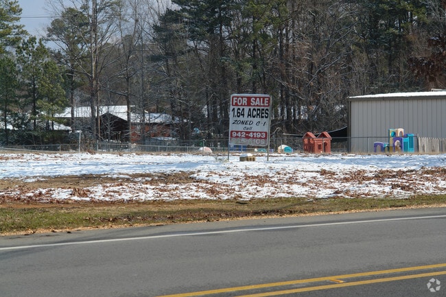
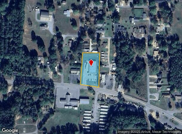
Property Record
1310 W Center St, Sheridan, AR 72150
NEARBY LISTINGS FOR SALE OR LEASE
-
-
View all Sheridan listings for sale on LoopNet.com
Property Detail
1310 W Center St
700-00543-000C
Eighth Addn
Wholesaleoutletdiscountstore
PT NW SE N. OF HWY 270
X
Grant
05053C0191C
Arkansas
2025
1.48 AC
2025
Grant County
470401
Little Rock/N Little Rock
9,160 SF
Little Rock-North Little Rock-Conway, AR
DEMOGRAPHICS near 1310 W Center St
1 Mile
3 Mile
5 Mile
2024 Total Population
2,543
6,964
7,925
2029 Population
2,631
7,237
8,242
Pop Growth 2024-2029
+ 3.46%
+ 3.92%
+ 4.00%
Average Age
39
40
40
2024 Total Households
1,010
2,769
3,148
HH Growth 2024-2029
+ 3.47%
+ 3.86%
+ 3.97%
Median Household Inc
$53,043
$59,154
$60,364
Avg Household Size
2.50
2.50
2.50
2024 Avg HH Vehicles
2.00
2.00
2.00
Median Home Value
$167,567
$163,519
$162,774
Median Year Built
1984
1986
1986
Nearby Places
Map Layers
Map Styles
 Street
 Aerial
- Restaurants
- Banks
- Shops
- Fitness
- Groceries
PUBLIC TRANSPORTATION
AIRPORT
Bill and Hillary Clinton Ntl/Adams Field
DRIVE
WALK
Distance
Bill and Hillary Clinton Ntl/Adams Field
42 min
35.5 mi
Nearby Properties
Address
Land Use
TOTAL SIZE
Lot Size
Zoning
Address
Land Use
TOTAL SIZE
Lot Size
Zoning
97,556 SF
8.06 AC
Address
Land Use
TOTAL SIZE
Lot Size
Zoning
224,670 SF
30.37 AC
Address
Land Use
TOTAL SIZE
Lot Size
Zoning
91,722 SF
11.50 AC
Address
Land Use
TOTAL SIZE
Lot Size
Zoning
7,812 SF
3 AC
Address
Land Use
TOTAL SIZE
Lot Size
Zoning
10,792 SF
4.37 AC
Address
Land Use
TOTAL SIZE
Lot Size
Zoning
21,590 SF
3.75 AC
Address
Land Use
TOTAL SIZE
Lot Size
Zoning
12,240 SF
3.75 AC
Address
Land Use
TOTAL SIZE
Lot Size
Zoning
23,110 SF
6.58 AC
Address
Land Use
TOTAL SIZE
Lot Size
Zoning
48,300 SF
6.35 AC
Address
Land Use
TOTAL SIZE
Lot Size
Zoning
8,968 SF
1.84 AC
Address
Land Use
TOTAL SIZE
Lot Size
Zoning
4,223 SF
3.17 AC
Address
Land Use
TOTAL SIZE
Lot Size
Zoning
7,882 SF
1.33 AC
Address
Land Use
TOTAL SIZE
Lot Size
Zoning
2,191 SF
2.48 AC
Address
Land Use
TOTAL SIZE
Lot Size
Zoning
20,592 SF
2.67 AC
Address
Land Use
TOTAL SIZE
Lot Size
Zoning
24,374 SF
2.97 AC
Address
Land Use
TOTAL SIZE
Lot Size
Zoning
20,800 SF
0.96 AC
Address
Land Use
TOTAL SIZE
Lot Size
Zoning
4,239 SF
1.01 AC
Address
Land Use
TOTAL SIZE
Lot Size
Zoning
5,116 SF
0.80 AC
Address
Land Use
TOTAL SIZE
Lot Size
Zoning
2,591 SF
12.98 AC
Address
Land Use
TOTAL SIZE
Lot Size
Zoning
111,514 SF
9 AC
Address
Land Use
TOTAL SIZE
Lot Size
Zoning
29,960 SF
4.58 AC
Address
Land Use
TOTAL SIZE
Lot Size
Zoning
3,363 SF
14.12 AC
Address
Land Use
TOTAL SIZE
Lot Size
Zoning
10,492 SF
1.35 AC
Address
Land Use
TOTAL SIZE
Lot Size
Zoning
19,312 SF
1.19 AC
Address
Land Use
TOTAL SIZE
Lot Size
Zoning
38,250 SF
3.16 AC
Address
Land Use
TOTAL SIZE
Lot Size
Zoning
7,800 SF
0.84 AC
Address
Land Use
TOTAL SIZE
Lot Size
Zoning
5,536 SF
0.92 AC
Address
Land Use
TOTAL SIZE
Lot Size
Zoning
10,900 SF
6.54 AC
Address
Land Use
TOTAL SIZE
Lot Size
Zoning
10,000 SF
5.35 AC
Address
Land Use
TOTAL SIZE
Lot Size
Zoning
1,952 SF
1.32 AC
The World's #1 Commercial Real Estate Marketplace
Connect with us
© 2026 CoStar Group
The information above has been obtained from sources believed reliable. While we do not doubt its accuracy we have not verified it and make no guarantee, warranty or representation about it. It is your responsibility to independently confirm its accuracy and completeness. Any projections, opinions, assumptions, or estimates used are for example only and do not represent the current or future performance of the property. The value of this transaction to you depends on tax and other factors which should be evaluated by your tax, financial, and legal advisors. You and your advisors should conduct a careful, independent investigation of the property to determine to your satisfaction the suitability of the property for your needs.