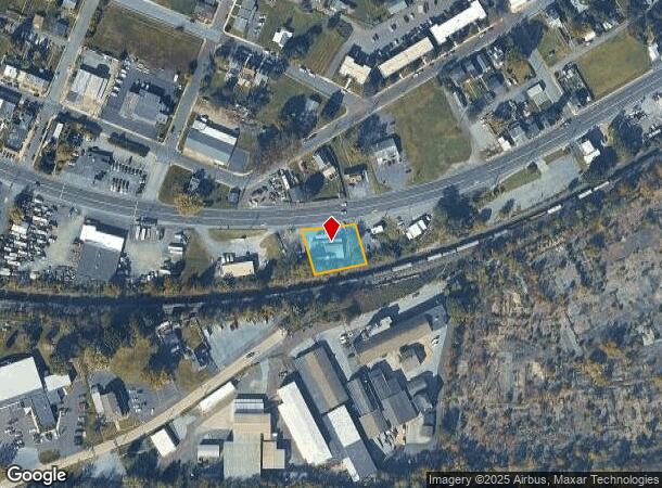
Property Record
1310 W High St, Pottstown, PA 19464
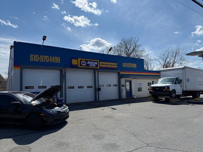
This Property Is For Sale
NEARBY LISTINGS FOR SALE OR LEASE
-
-
View all Pottstown listings for sale on LoopNet.com
Property Detail
1310 W High St
64-00-02335-004
B 24 U 47
Servicestation
Montgomery
X
Pennsylvania
42029C0015G
29
2024
0.64 AC
2025
West Montgomery County
209201
Philadelphia
1,650 SF
Philadelphia-Camden-Wilmington, PA-NJ-DE-MD
DEMOGRAPHICS near 1310 W High St
1 Mile
3 Mile
5 Mile
2024 Total Population
4,911
36,825
75,211
2029 Population
4,948
37,372
76,413
Pop Growth 2024-2029
+ 0.75%
+ 1.49%
+ 1.60%
Average Age
40
40
41
2024 Total Households
2,001
14,904
29,109
HH Growth 2024-2029
+ 0.70%
+ 1.43%
+ 1.60%
Median Household Inc
$64,206
$60,468
$77,406
Avg Household Size
2.40
2.40
2.50
2024 Avg HH Vehicles
2.00
2.00
2.00
Median Home Value
$167,166
$186,736
$241,180
Median Year Built
1955
1956
1969
Nearby Places
Map Layers
Map Styles
 Street
 Aerial
- Restaurants
- Banks
- Shops
- Fitness
- Groceries
PUBLIC TRANSPORTATION
AIRPORT
Lehigh Valley International
DRIVE
WALK
Distance
Lehigh Valley International
61 min
34.4 mi
Philadelphia International
DRIVE
WALK
Distance
Philadelphia International
73 min
49.6 mi
Freight Ports
Port of Wilmington, RI
DRIVE
WALK
Distance
Port of Wilmington, RI
76 min
44.2 mi
Nearby Properties
Address
Land Use
TOTAL SIZE
Lot Size
Zoning
Address
Land Use
TOTAL SIZE
Lot Size
Zoning
707,965 SF
80.33 AC
RMHD
Address
Land Use
TOTAL SIZE
Lot Size
Zoning
406,166 SF
65.54 AC
C
Address
Land Use
TOTAL SIZE
Lot Size
Zoning
327,827 SF
21 AC
RMD
Address
Land Use
TOTAL SIZE
Lot Size
Zoning
181,947 SF
8.19 AC
RMD
Address
Land Use
TOTAL SIZE
Lot Size
Zoning
135,368 SF
5.31 AC
DG
Address
Land Use
TOTAL SIZE
Lot Size
Zoning
150,711 SF
21.72 AC
HB
Address
Land Use
TOTAL SIZE
Lot Size
Zoning
216,693 SF
38 AC
I1
Address
Land Use
TOTAL SIZE
Lot Size
Zoning
176,741 SF
17.40 AC
HB
Address
Land Use
TOTAL SIZE
Lot Size
Zoning
589,859 SF
53.31 AC
C2
Address
Land Use
TOTAL SIZE
Lot Size
Zoning
138,563 SF
12.98 AC
C
Address
Land Use
TOTAL SIZE
Lot Size
Zoning
114,995 SF
4.30 AC
Address
Land Use
TOTAL SIZE
Lot Size
Zoning
80,236 SF
3.78 AC
Address
Land Use
TOTAL SIZE
Lot Size
Zoning
290,108 SF
23 AC
Address
Land Use
TOTAL SIZE
Lot Size
Zoning
165,168 SF
11.10 AC
C2
Address
Land Use
TOTAL SIZE
Lot Size
Zoning
175,151 SF
14.74 AC
RMHD
Address
Land Use
TOTAL SIZE
Lot Size
Zoning
186,504 SF
24.23 AC
Address
Land Use
TOTAL SIZE
Lot Size
Zoning
166,912 SF
11.10 AC
R4
Address
Land Use
TOTAL SIZE
Lot Size
Zoning
66,270 SF
1.20 AC
R1
Address
Land Use
TOTAL SIZE
Lot Size
Zoning
79,010 SF
13.75 AC
C2
Address
Land Use
TOTAL SIZE
Lot Size
Zoning
77,944 SF
0.47 AC
D
Address
Land Use
TOTAL SIZE
Lot Size
Zoning
61,031 SF
14.54 AC
R3
Address
Land Use
TOTAL SIZE
Lot Size
Zoning
45,138 SF
9.13 AC
C
Address
Land Use
TOTAL SIZE
Lot Size
Zoning
56,774 SF
1.58 AC
C
Address
Land Use
TOTAL SIZE
Lot Size
Zoning
227,008 SF
0.79 AC
TTN
Address
Land Use
TOTAL SIZE
Lot Size
Zoning
78,770 SF
2.20 AC
RHD
Address
Land Use
TOTAL SIZE
Lot Size
Zoning
48,772 SF
6.17 AC
Address
Land Use
TOTAL SIZE
Lot Size
Zoning
522,093 SF
23.50 AC
HM
Address
Land Use
TOTAL SIZE
Lot Size
Zoning
51,586 SF
5.77 AC
RLD
Address
Land Use
TOTAL SIZE
Lot Size
Zoning
31,680 SF
7.48 AC
R3
Address
Land Use
TOTAL SIZE
Lot Size
Zoning
63,523 SF
4 AC
FO
The World's #1 Commercial Real Estate Marketplace
Connect with us
© 2025 CoStar Group
The information above has been obtained from sources believed reliable. While we do not doubt its accuracy we have not verified it and make no guarantee, warranty or representation about it. It is your responsibility to independently confirm its accuracy and completeness. Any projections, opinions, assumptions, or estimates used are for example only and do not represent the current or future performance of the property. The value of this transaction to you depends on tax and other factors which should be evaluated by your tax, financial, and legal advisors. You and your advisors should conduct a careful, independent investigation of the property to determine to your satisfaction the suitability of the property for your needs.