Property Record
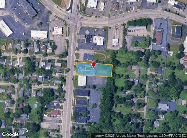
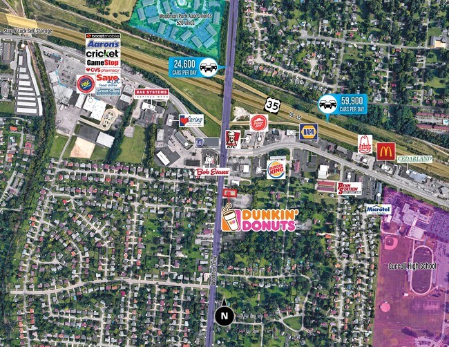
1310 Woodman Dr, Dayton, OH 45432
NEARBY LISTINGS FOR SALE OR LEASE
Property Detail
1310 Woodman Dr
I39101502-0078
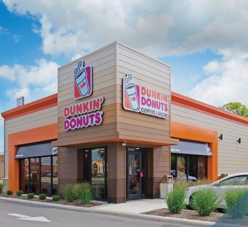
Dunkin Donuts
Restaurantbuilding
1 DUNKIN DONUTS
X
Montgomery
39113C0276F
Ohio
2023
0.99 AC
2024
South Central Dayton
091000
Cincinnati/Dayton
2,042 SF
Dayton, OH
DEMOGRAPHICS near 1310 Woodman Dr
1 Mile
3 Mile
5 Mile
2024 Total Population
10,757
96,741
209,029
2029 Population
10,553
96,741
210,140
Pop Growth 2024-2029
(1.90%)
0.00%
+ 0.53%
Average Age
40
38
39
2024 Total Households
4,960
40,983
88,743
HH Growth 2024-2029
(1.96%)
(0.10%)
+ 0.52%
Median Household Inc
$51,584
$52,828
$58,902
Avg Household Size
2.10
2.20
2.20
2024 Avg HH Vehicles
2.00
2.00
2.00
Median Home Value
$94,968
$118,965
$160,196
Median Year Built
1955
1954
1959
Nearby Places
Map Layers
Map Styles
 Street
 Aerial
- Restaurants
- Banks
- Shops
- Fitness
- Groceries
PUBLIC TRANSPORTATION
AIRPORT
James M Cox Dayton International
DRIVE
WALK
Distance
James M Cox Dayton International
27 min
16.5 mi
Freight Ports
Port of Toledo
DRIVE
WALK
Distance
Port of Toledo
184 min
156.7 mi
SALE & LEASE HISTORY
LISTING DATE
SALE/LEASE

Aug 24, 2017
For Sale
Aug 15, 2017
For Sale
Aug 11, 2017
For Sale
Nearby Properties
Address
Land Use
TOTAL SIZE
Lot Size
Zoning
Address
Land Use
TOTAL SIZE
Lot Size
Zoning
634,753 SF
54 AC
Address
Land Use
TOTAL SIZE
Lot Size
Zoning
316.77 AC
Address
Land Use
TOTAL SIZE
Lot Size
Zoning
752,874 SF
74.85 AC
Address
Land Use
TOTAL SIZE
Lot Size
Zoning
23.35 AC
Address
Land Use
TOTAL SIZE
Lot Size
Zoning
175,938 SF
49.33 AC
Address
Land Use
TOTAL SIZE
Lot Size
Zoning
53.48 AC
RP1
Address
Land Use
TOTAL SIZE
Lot Size
Zoning
130,247 SF
14.12 AC
Address
Land Use
TOTAL SIZE
Lot Size
Zoning
Address
Land Use
TOTAL SIZE
Lot Size
Zoning
133.37 AC
Address
Land Use
TOTAL SIZE
Lot Size
Zoning
4.86 AC
Address
Land Use
TOTAL SIZE
Lot Size
Zoning
46,796 SF
53.05 AC
RPUD038
Address
Land Use
TOTAL SIZE
Lot Size
Zoning
41.38 AC
Address
Land Use
TOTAL SIZE
Lot Size
Zoning
54.85 AC
Address
Land Use
TOTAL SIZE
Lot Size
Zoning
46.32 AC
Address
Land Use
TOTAL SIZE
Lot Size
Zoning
32.30 AC
Address
Land Use
TOTAL SIZE
Lot Size
Zoning
4.98 AC
Address
Land Use
TOTAL SIZE
Lot Size
Zoning
96,732 SF
6.73 AC
CPUD002
Address
Land Use
TOTAL SIZE
Lot Size
Zoning
94,608 SF
7.44 AC
Address
Land Use
TOTAL SIZE
Lot Size
Zoning
406,186 SF
36.48 AC
Address
Land Use
TOTAL SIZE
Lot Size
Zoning
89,176 SF
17.52 AC
Address
Land Use
TOTAL SIZE
Lot Size
Zoning
309,331 SF
36 AC
Address
Land Use
TOTAL SIZE
Lot Size
Zoning
23.20 AC
Address
Land Use
TOTAL SIZE
Lot Size
Zoning
20,144 SF
76.94 AC
A1
Address
Land Use
TOTAL SIZE
Lot Size
Zoning
Address
Land Use
TOTAL SIZE
Lot Size
Zoning
101,262 SF
10.83 AC
Address
Land Use
TOTAL SIZE
Lot Size
Zoning
10.47 AC
Address
Land Use
TOTAL SIZE
Lot Size
Zoning
11.58 AC
Address
Land Use
TOTAL SIZE
Lot Size
Zoning
72,824 SF
26.88 AC
A1
Address
Land Use
TOTAL SIZE
Lot Size
Zoning
318,166 SF
49.51 AC
Address
Land Use
TOTAL SIZE
Lot Size
Zoning
51,648 SF
9.36 AC
R-PUD 95-2
The World's #1 Commercial Real Estate Marketplace
Connect with us
© 2025 CoStar Group
The information above has been obtained from sources believed reliable. While we do not doubt its accuracy we have not verified it and make no guarantee, warranty or representation about it. It is your responsibility to independently confirm its accuracy and completeness. Any projections, opinions, assumptions, or estimates used are for example only and do not represent the current or future performance of the property. The value of this transaction to you depends on tax and other factors which should be evaluated by your tax, financial, and legal advisors. You and your advisors should conduct a careful, independent investigation of the property to determine to your satisfaction the suitability of the property for your needs.