Property Record
1311 159Th Ave, Ashland, CA 94578
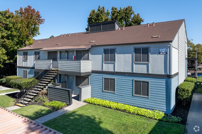

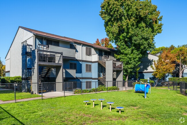
Property Detail
1311 159Th Ave
Oakland-Fremont-Berkeley, CA
PORTION LOT8
080C-0500-006-00
ALAMEDA
Multifamilydwelling
California
AH Areas with a 1% annual chance of shallow flooding, usually in the form of a pond, withan average depth ranging from 1 to 3 feet. These areas have a 26% chance of flooding over the life of a 30-year mortgage.
8
2024
5.32 AC
2025
Ashland
433802
East Bay/Oakland
105,730 SF
NEARBY LISTINGS FOR SALE OR LEASE
DEMOGRAPHICS near 1311 159Th Ave
1 mile
3 mile
5 mile
2025 Total Population
33,410
196,323
376,823
2030 Population
33,188
195,174
375,060
Pop Growth 2025-2030
(0.66%)
(0.59%)
(0.47%)
Average Age
39
41
40
2025 Total Households
11,346
66,237
122,035
HH Growth 2025-2030
(0.79%)
(0.67%)
(0.57%)
Median Household Inc
$83,499
$100,963
$101,236
Avg Household Size
2.80
2.90
3.00
2025 Avg HH Vehicles
2.00
2.00
2.00
Median Home Value
$759,930
$810,785
$807,887
Median Year Built
1968
1960
1962
Nearby Places
Map Layers
Map Styles
 Street
 Aerial
Layers
 Traffic
 Biking
Places
Listings with unknown addresses are not visible on the map
- Restaurants
- Banks
- Shops
- Fitness
- Groceries
PUBLIC TRANSPORTATION
TRANSIT/SUBWAY
Bay Fair Station (Dublin/Pleasanton - Millbrae - Bay Area Rapid Transit (BART), Fremont - Daly City - Bay Area Rapid Transit (BART), Fremont - Richmond - Bay Area Rapid Transit (BART))
Drive
Walk
Distance
Bay Fair Station (Dublin/Pleasanton - Millbrae - Bay Area Rapid Transit (BART), Fremont - Daly City - Bay Area Rapid Transit (BART), Fremont - Richmond - Bay Area Rapid Transit (BART))
2 min
9 min
0.5 mi
COMMUTER RAIL
Hayward Amtrak (Capitol Corridor - Amtrak)
Drive
Walk
Distance
Hayward Amtrak (Capitol Corridor - Amtrak)
8 min
3.0 mi
Hayward (Capitol Corridor - Capitol Corridor Joint Powers Authority)
Drive
Walk
Distance
Hayward (Capitol Corridor - Capitol Corridor Joint Powers Authority)
8 min
3.0 mi
AIRPORT
Metro Oakland International
Drive
Walk
Distance
Metro Oakland International
14 min
7.5 mi
San Francisco International
Drive
Walk
Distance
San Francisco International
35 min
26.4 mi
Norman Y Mineta San Jose International
Drive
Walk
Distance
Norman Y Mineta San Jose International
40 min
30.9 mi
Freight Ports
Port of Oakland
Drive
Walk
Distance
Port of Oakland
18 min
12.2 mi
Nearby Properties
Address
Land Use
TOTAL SIZE
Lot Size
Zoning
Address
Land Use
TOTAL SIZE
Lot Size
Zoning
298,256 SF
12.16 AC
Address
Land Use
TOTAL SIZE
Lot Size
Zoning
4.90 AC
Address
Land Use
TOTAL SIZE
Lot Size
Zoning
437,104 SF
0.73 AC
Address
Land Use
TOTAL SIZE
Lot Size
Zoning
2.48 AC
Address
Land Use
TOTAL SIZE
Lot Size
Zoning
726,931 SF
37.03 AC
Address
Land Use
TOTAL SIZE
Lot Size
Zoning
1.64 AC
Address
Land Use
TOTAL SIZE
Lot Size
Zoning
203,925 SF
8.54 AC
Address
Land Use
TOTAL SIZE
Lot Size
Zoning
1.50 AC
Address
Land Use
TOTAL SIZE
Lot Size
Zoning
99,039 SF
1.04 AC
Address
Land Use
TOTAL SIZE
Lot Size
Zoning
235,760 SF
9.52 AC
Address
Land Use
TOTAL SIZE
Lot Size
Zoning
187,926 SF
1.19 AC
Address
Land Use
TOTAL SIZE
Lot Size
Zoning
292,698 SF
12.92 AC
Address
Land Use
TOTAL SIZE
Lot Size
Zoning
693,679 SF
43.49 AC
Address
Land Use
TOTAL SIZE
Lot Size
Zoning
294,146 SF
14.22 AC
Address
Land Use
TOTAL SIZE
Lot Size
Zoning
133,974 SF
4.99 AC
Address
Land Use
TOTAL SIZE
Lot Size
Zoning
240,668 SF
14.11 AC
Address
Land Use
TOTAL SIZE
Lot Size
Zoning
241,382 SF
12.72 AC
Address
Land Use
TOTAL SIZE
Lot Size
Zoning
297,592 SF
11.65 AC
Address
Land Use
TOTAL SIZE
Lot Size
Zoning
310,072 SF
14.96 AC
Address
Land Use
TOTAL SIZE
Lot Size
Zoning
458,489 SF
27.38 AC
Address
Land Use
TOTAL SIZE
Lot Size
Zoning
228,736 SF
5.95 AC
Address
Land Use
TOTAL SIZE
Lot Size
Zoning
24.51 AC
Address
Land Use
TOTAL SIZE
Lot Size
Zoning
132,018 SF
1.11 AC
Address
Land Use
TOTAL SIZE
Lot Size
Zoning
169,371 SF
4.63 AC
Address
Land Use
TOTAL SIZE
Lot Size
Zoning
625,101 SF
35.95 AC
Address
Land Use
TOTAL SIZE
Lot Size
Zoning
168,104 SF
13.73 AC
Address
Land Use
TOTAL SIZE
Lot Size
Zoning
136,618 SF
6.34 AC
Address
Land Use
TOTAL SIZE
Lot Size
Zoning
243,524 SF
15.17 AC
Address
Land Use
TOTAL SIZE
Lot Size
Zoning
149,602 SF
6.90 AC
The World's #1 Commercial Real Estate Marketplace
Connect with us
© 2026 CoStar Group
The information above has been obtained from sources believed reliable. While we do not doubt its accuracy we have not verified it and make no guarantee, warranty or representation about it. It is your responsibility to independently confirm its accuracy and completeness. Any projections, opinions, assumptions, or estimates used are for example only and do not represent the current or future performance of the property. The value of this transaction to you depends on tax and other factors which should be evaluated by your tax, financial, and legal advisors. You and your advisors should conduct a careful, independent investigation of the property to determine to your satisfaction the suitability of the property for your needs.