Property Record
1311 E Harding St, Morrilton, AR 72110
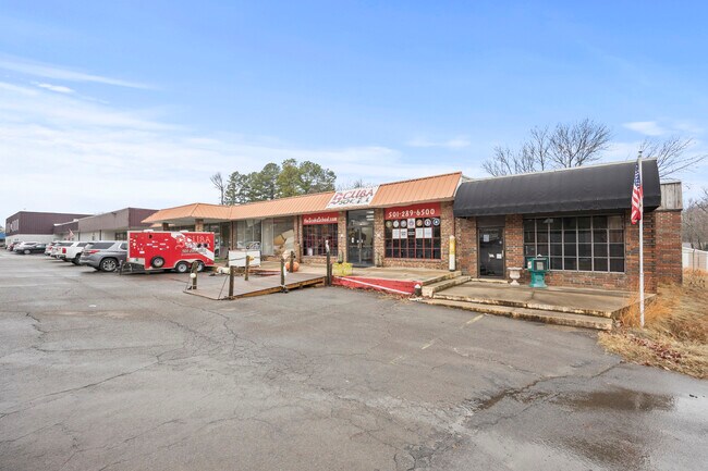


Property Detail
1311 E Harding St
006-02854-005-C
FRL LOT C
Storebuilding
CONWAY
B and X Area of moderate flood hazard, usually the area between the limits of the 100-year and 500-year floods.
Arkansas
2025
c
2025
0.18 AC
950300
Arkansas North Area
2,100 SF
Other Market Areas
NEARBY LISTINGS FOR SALE OR LEASE
DEMOGRAPHICS near 1311 E Harding St
1 mile
3 mile
5 mile
2025 Total Population
2,642
8,921
11,201
2030 Population
2,737
9,198
11,523
Pop Growth 2025-2030
+ 3.60%
+ 3.11%
+ 2.87%
Average Age
42
40
41
2025 Total Households
1,088
3,621
4,545
HH Growth 2025-2030
+ 3.58%
+ 3.09%
+ 2.86%
Median Household Inc
$54,153
$40,862
$46,093
Avg Household Size
2.30
2.40
2.40
2025 Avg HH Vehicles
2.00
2.00
2.00
Median Home Value
$143,148
$152,401
$153,455
Median Year Built
1970
1974
1976
Nearby Places
Map Layers
Map Styles
 Street
 Aerial
Transit
 Traffic
 Biking
Places
Listings with unknown addresses are not visible on the map
- Restaurants
- Banks
- Shops
- Fitness
- Groceries
SALE & LEASE HISTORY
LISTING DATE
SALE/LEASE

Jan 29, 2024
For Sale
Nearby Properties
Address
Land Use
TOTAL SIZE
Lot Size
Zoning
Address
Land Use
TOTAL SIZE
Lot Size
Zoning
124,126 SF
14.52 AC
Address
Land Use
TOTAL SIZE
Lot Size
Zoning
44,044 SF
1.55 AC
Address
Land Use
TOTAL SIZE
Lot Size
Zoning
36,313 SF
6.48 AC
Address
Land Use
TOTAL SIZE
Lot Size
Zoning
200,764 SF
32.26 AC
Address
Land Use
TOTAL SIZE
Lot Size
Zoning
56,848 SF
4.62 AC
Address
Land Use
TOTAL SIZE
Lot Size
Zoning
89,600 SF
8.50 AC
Address
Land Use
TOTAL SIZE
Lot Size
Zoning
54,780 SF
12.58 AC
Address
Land Use
TOTAL SIZE
Lot Size
Zoning
116,330 SF
9.48 AC
Address
Land Use
TOTAL SIZE
Lot Size
Zoning
26,688 SF
30 AC
Address
Land Use
TOTAL SIZE
Lot Size
Zoning
87,640 SF
8.63 AC
Address
Land Use
TOTAL SIZE
Lot Size
Zoning
32,939 SF
3.64 AC
Address
Land Use
TOTAL SIZE
Lot Size
Zoning
4,439 SF
0.89 AC
Address
Land Use
TOTAL SIZE
Lot Size
Zoning
23,644 SF
2.34 AC
Address
Land Use
TOTAL SIZE
Lot Size
Zoning
23,031 SF
4 AC
Address
Land Use
TOTAL SIZE
Lot Size
Zoning
14,417 SF
4.52 AC
Address
Land Use
TOTAL SIZE
Lot Size
Zoning
4,624 SF
8.46 AC
Address
Land Use
TOTAL SIZE
Lot Size
Zoning
66,520 SF
15.50 AC
Address
Land Use
TOTAL SIZE
Lot Size
Zoning
20,151 SF
0.57 AC
Address
Land Use
TOTAL SIZE
Lot Size
Zoning
5,485 SF
6.11 AC
Address
Land Use
TOTAL SIZE
Lot Size
Zoning
19,120 SF
3.66 AC
Address
Land Use
TOTAL SIZE
Lot Size
Zoning
29,037 SF
1.03 AC
Address
Land Use
TOTAL SIZE
Lot Size
Zoning
28,352 SF
4.66 AC
Address
Land Use
TOTAL SIZE
Lot Size
Zoning
29,427 SF
4.07 AC
Address
Land Use
TOTAL SIZE
Lot Size
Zoning
11,149 SF
2 AC
Address
Land Use
TOTAL SIZE
Lot Size
Zoning
63,772 SF
10 AC
Address
Land Use
TOTAL SIZE
Lot Size
Zoning
11,690 SF
13.35 AC
Address
Land Use
TOTAL SIZE
Lot Size
Zoning
2,960 SF
Address
Land Use
TOTAL SIZE
Lot Size
Zoning
17,728 SF
1.66 AC
Address
Land Use
TOTAL SIZE
Lot Size
Zoning
31,908 SF
4.79 AC
Address
Land Use
TOTAL SIZE
Lot Size
Zoning
28,370 SF
12.29 AC
The World's #1 Commercial Real Estate Marketplace
Connect with us
© 2026 CoStar Group
The information above has been obtained from sources believed reliable. While we do not doubt its accuracy we have not verified it and make no guarantee, warranty or representation about it. It is your responsibility to independently confirm its accuracy and completeness. Any projections, opinions, assumptions, or estimates used are for example only and do not represent the current or future performance of the property. The value of this transaction to you depends on tax and other factors which should be evaluated by your tax, financial, and legal advisors. You and your advisors should conduct a careful, independent investigation of the property to determine to your satisfaction the suitability of the property for your needs.