No Photo
Property Record
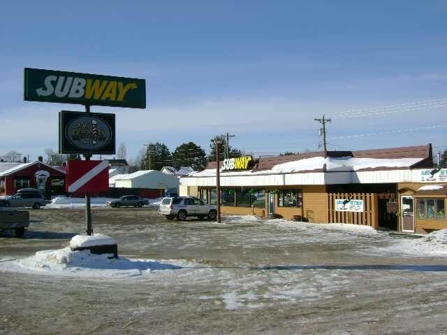
1311 E Sheridan St, Ely, MN 55731

Property Detail
1311 E Sheridan St
Duluth, MN-WI
LOTS 1 THRU 4 SERIAL #
030035200210
Saint Louis
Commercialnec
Minnesota
B and X Area of moderate flood hazard, usually the area between the limits of the 100-year and 500-year floods.
1-4
2025
0.29 AC
2024
North St Louis County
015300
Duluth
2,082 SF
NEARBY LISTINGS FOR SALE OR LEASE
-
-
View all Ely listings for lease on LoopNet.com
DEMOGRAPHICS near 1311 E Sheridan St
1 mile
3 mile
5 mile
2024 Total Population
2,811
4,502
5,483
2029 Population
2,874
4,629
5,662
Pop Growth 2024-2029
+ 2.24%
+ 2.82%
+ 3.26%
Average Age
44
46
47
2024 Total Households
1,343
2,193
2,674
HH Growth 2024-2029
+ 2.31%
+ 2.78%
+ 3.29%
Median Household Inc
$53,863
$59,130
$63,068
Avg Household Size
1.80
1.90
1.90
2024 Avg HH Vehicles
2.00
2.00
2.00
Median Home Value
$172,482
$190,985
$217,865
Median Year Built
1954
1960
1970
Nearby Places
Map Layers
Map Styles
 Street
 Aerial
Transit
 Traffic
 Biking
Places
Listings with unknown addresses are not visible on the map
- Restaurants
- Banks
- Shops
- Fitness
- Groceries
SALE & LEASE HISTORY
LISTING DATE
SALE/LEASE

Sep 25, 2016
For Lease
Sep 23, 2016
For Sale
Jul 16, 2018
For Lease
Nearby Properties
Address
Land Use
TOTAL SIZE
Lot Size
Zoning
Address
Land Use
TOTAL SIZE
Lot Size
Zoning
87,055 SF
39.08 AC
Address
Land Use
TOTAL SIZE
Lot Size
Zoning
119,436 SF
10.50 AC
Address
Land Use
TOTAL SIZE
Lot Size
Zoning
1.76 AC
Address
Land Use
TOTAL SIZE
Lot Size
Zoning
13,575 SF
16.80 AC
Address
Land Use
TOTAL SIZE
Lot Size
Zoning
4,272 SF
4.87 AC
Address
Land Use
TOTAL SIZE
Lot Size
Zoning
16,862 SF
0.43 AC
Address
Land Use
TOTAL SIZE
Lot Size
Zoning
20,000 SF
38.90 AC
SMU
Address
Land Use
TOTAL SIZE
Lot Size
Zoning
22,064 SF
18.33 AC
MUNS
Address
Land Use
TOTAL SIZE
Lot Size
Zoning
9,990 SF
1.66 AC
Address
Land Use
TOTAL SIZE
Lot Size
Zoning
33,208 SF
2.07 AC
Address
Land Use
TOTAL SIZE
Lot Size
Zoning
119,436 SF
0.78 AC
Address
Land Use
TOTAL SIZE
Lot Size
Zoning
19,218 SF
8.50 AC
Address
Land Use
TOTAL SIZE
Lot Size
Zoning
36,454 SF
1.49 AC
Address
Land Use
TOTAL SIZE
Lot Size
Zoning
28,719 SF
1.30 AC
Address
Land Use
TOTAL SIZE
Lot Size
Zoning
48,816 SF
4.70 AC
Address
Land Use
TOTAL SIZE
Lot Size
Zoning
320 SF
26.52 AC
MUNS
Address
Land Use
TOTAL SIZE
Lot Size
Zoning
119,436 SF
0.54 AC
Address
Land Use
TOTAL SIZE
Lot Size
Zoning
33,540 SF
3 AC
Address
Land Use
TOTAL SIZE
Lot Size
Zoning
430 AC
RES
Address
Land Use
TOTAL SIZE
Lot Size
Zoning
640 AC
MUNS
Address
Land Use
TOTAL SIZE
Lot Size
Zoning
16,176 SF
2.21 AC
Address
Land Use
TOTAL SIZE
Lot Size
Zoning
16,806 SF
0.43 AC
Address
Land Use
TOTAL SIZE
Lot Size
Zoning
16,170 SF
2.24 AC
Address
Land Use
TOTAL SIZE
Lot Size
Zoning
6,714 SF
2.06 AC
Address
Land Use
TOTAL SIZE
Lot Size
Zoning
6,960 SF
2.84 AC
Address
Land Use
TOTAL SIZE
Lot Size
Zoning
2 AC
RES
Address
Land Use
TOTAL SIZE
Lot Size
Zoning
5,822 SF
0.36 AC
Address
Land Use
TOTAL SIZE
Lot Size
Zoning
1,692 SF
1.45 AC
Address
Land Use
TOTAL SIZE
Lot Size
Zoning
23.45 AC
Address
Land Use
TOTAL SIZE
Lot Size
Zoning
6,586 SF
0.65 AC
The World's #1 Commercial Real Estate Marketplace
Connect with us
© 2026 CoStar Group
The information above has been obtained from sources believed reliable. While we do not doubt its accuracy we have not verified it and make no guarantee, warranty or representation about it. It is your responsibility to independently confirm its accuracy and completeness. Any projections, opinions, assumptions, or estimates used are for example only and do not represent the current or future performance of the property. The value of this transaction to you depends on tax and other factors which should be evaluated by your tax, financial, and legal advisors. You and your advisors should conduct a careful, independent investigation of the property to determine to your satisfaction the suitability of the property for your needs.