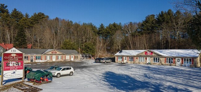
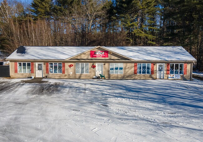
Property Record
1311 Roosevelt Trl, Raymond, ME 04071

Property Detail
1311 Roosevelt Trl
RYMD-000051-000000-000012
Cumberland
Commercialnec
Maine
C
12
B and X Area of moderate flood hazard, usually the area between the limits of the 100-year and 500-year floods.
4.98 AC
2024
NE Cumberland County
2024
Portland/South Portland
012002
Portland-South Portland, ME
NEARBY LISTINGS FOR SALE OR LEASE
DEMOGRAPHICS near 1311 Roosevelt Trl
1 mile
3 mile
5 mile
2025 Total Population
1,029
5,124
15,500
2030 Population
1,084
5,416
16,218
Pop Growth 2025-2030
+ 5.34%
+ 5.70%
+ 4.63%
Average Age
45
45
44
2025 Total Households
433
2,190
6,255
HH Growth 2025-2030
+ 5.77%
+ 6.03%
+ 4.94%
Median Household Inc
$92,424
$97,663
$100,255
Avg Household Size
2.30
2.30
2.30
2025 Avg HH Vehicles
2.00
2.00
2.00
Median Home Value
$484,615
$547,829
$458,660
Median Year Built
1976
1977
1980
Nearby Places
Map Layers
Map Styles
 Street
 Aerial
Layers
 Traffic
 Biking
Places
Listings with unknown addresses are not visible on the map
- Restaurants
- Banks
- Shops
- Fitness
- Groceries
PUBLIC TRANSPORTATION
AIRPORT
Portland International Jetport
Drive
Walk
Distance
Portland International Jetport
37 min
21.3 mi
Freight Ports
Portland, ME
Drive
Walk
Distance
Portland, ME
33 min
21.3 mi
SALE & LEASE HISTORY
LISTING DATE
SALE/LEASE

Jan 31, 2023
For Sale
Nearby Properties
Address
Land Use
TOTAL SIZE
Lot Size
Zoning
Address
Land Use
TOTAL SIZE
Lot Size
Zoning
4.33 AC
C1
Address
Land Use
TOTAL SIZE
Lot Size
Zoning
Address
Land Use
TOTAL SIZE
Lot Size
Zoning
60.50 AC
LRR2
Address
Land Use
TOTAL SIZE
Lot Size
Zoning
12.52 AC
VR1
Address
Land Use
TOTAL SIZE
Lot Size
Zoning
82.10 AC
I
Address
Land Use
TOTAL SIZE
Lot Size
Zoning
0.20 AC
VR2
Address
Land Use
TOTAL SIZE
Lot Size
Zoning
40,206 SF
6.76 AC
ED
Address
Land Use
TOTAL SIZE
Lot Size
Zoning
121,478 SF
77.64 AC
I,RR2
Address
Land Use
TOTAL SIZE
Lot Size
Zoning
37,823 SF
3.46 AC
C-1N
Address
Land Use
TOTAL SIZE
Lot Size
Zoning
3.10 AC
LRR2
Address
Land Use
TOTAL SIZE
Lot Size
Zoning
22.03 AC
C-1N/R
Address
Land Use
TOTAL SIZE
Lot Size
Zoning
3,600 SF
50.24 AC
ED/RP-
Address
Land Use
TOTAL SIZE
Lot Size
Zoning
16,966 SF
5.73 AC
1
Address
Land Use
TOTAL SIZE
Lot Size
Zoning
3.75 AC
LRR2
Address
Land Use
TOTAL SIZE
Lot Size
Zoning
680 SF
32 AC
LRR2
Address
Land Use
TOTAL SIZE
Lot Size
Zoning
17.50 AC
LRR2
Address
Land Use
TOTAL SIZE
Lot Size
Zoning
1.39 AC
LRR2
Address
Land Use
TOTAL SIZE
Lot Size
Zoning
576 SF
3.95 AC
LRR2
Address
Land Use
TOTAL SIZE
Lot Size
Zoning
3.88 AC
LRR2
Address
Land Use
TOTAL SIZE
Lot Size
Zoning
12,545 SF
1.84 AC
ED
Address
Land Use
TOTAL SIZE
Lot Size
Zoning
3.83 AC
C-1
Address
Land Use
TOTAL SIZE
Lot Size
Zoning
5.40 AC
C
Address
Land Use
TOTAL SIZE
Lot Size
Zoning
2 AC
LRR2
Address
Land Use
TOTAL SIZE
Lot Size
Zoning
3.50 AC
LRR2
Address
Land Use
TOTAL SIZE
Lot Size
Zoning
14,560 SF
6.03 AC
ED
Address
Land Use
TOTAL SIZE
Lot Size
Zoning
3.63 AC
LRR2
Address
Land Use
TOTAL SIZE
Lot Size
Zoning
6 AC
LRR2
Address
Land Use
TOTAL SIZE
Lot Size
Zoning
3.69 AC
RL
Address
Land Use
TOTAL SIZE
Lot Size
Zoning
90 AC
LRR1
Address
Land Use
TOTAL SIZE
Lot Size
Zoning
3.04 AC
C-1N
The World's #1 Commercial Real Estate Marketplace
Connect with us
© 2026 CoStar Group
The information above has been obtained from sources believed reliable. While we do not doubt its accuracy we have not verified it and make no guarantee, warranty or representation about it. It is your responsibility to independently confirm its accuracy and completeness. Any projections, opinions, assumptions, or estimates used are for example only and do not represent the current or future performance of the property. The value of this transaction to you depends on tax and other factors which should be evaluated by your tax, financial, and legal advisors. You and your advisors should conduct a careful, independent investigation of the property to determine to your satisfaction the suitability of the property for your needs.