Property Record
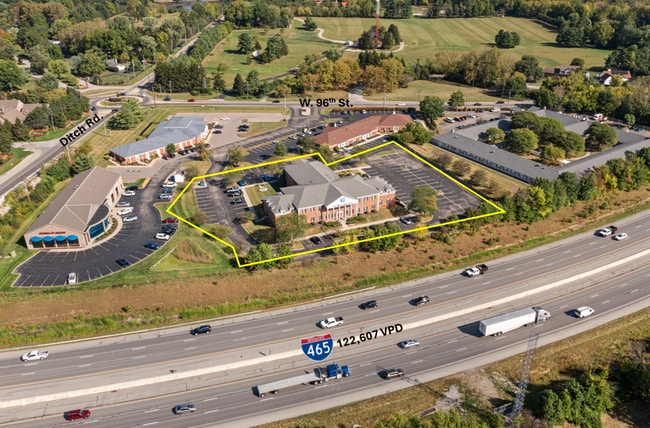
1311 W 96Th St, Indianapolis, IN 46260

Current Lease Availabilities
NEARBY LISTINGS FOR SALE OR LEASE
Property Detail
1311 W 96Th St
49-03-15-124-008.000-800
PT NW1/4 NW1/4 S15-17-3 453E 122.23S 259.27SW68.85S OF NW COR SW 51.02 S106.9 SE151.7 S30.51 NE CURVE 330.49 NW301.92 SSW95.25 SWCURVE 44.51 W15 N21 WSW149.23 TO BEG 2.255AC
Officebuilding
Marion
X
Indiana
18097C0041F
1
2023
2.26 AC
2024
Meridian Corridor
320106
Indianapolis
24,816 SF
Indianapolis-Carmel-Greenwood, IN
DEMOGRAPHICS near 1311 W 96Th St
1 Mile
3 Mile
5 Mile
2024 Total Population
6,820
61,863
168,258
2029 Population
6,910
63,348
176,263
Pop Growth 2024-2029
+ 1.32%
+ 2.40%
+ 4.76%
Average Age
42
40
40
2024 Total Households
3,026
27,806
72,791
HH Growth 2024-2029
+ 0.73%
+ 1.73%
+ 4.36%
Median Household Inc
$74,855
$73,259
$84,365
Avg Household Size
2.20
2.20
2.20
2024 Avg HH Vehicles
2.00
2.00
2.00
Median Home Value
$344,425
$304,883
$320,416
Median Year Built
1981
1980
1985
Nearby Places
Map Layers
Map Styles
 Street
 Aerial
- Restaurants
- Banks
- Shops
- Fitness
- Groceries
PUBLIC TRANSPORTATION
AIRPORT
Indianapolis International
DRIVE
WALK
Distance
Indianapolis International
46 min
25.6 mi
Nearby Properties
Address
Land Use
TOTAL SIZE
Lot Size
Zoning
Address
Land Use
TOTAL SIZE
Lot Size
Zoning
303,520 SF
39.62 AC
ZO01
Address
Land Use
TOTAL SIZE
Lot Size
Zoning
239,161 SF
12.12 AC
Address
Land Use
TOTAL SIZE
Lot Size
Zoning
267,771 SF
13.10 AC
Address
Land Use
TOTAL SIZE
Lot Size
Zoning
408,298 SF
15.67 AC
Address
Land Use
TOTAL SIZE
Lot Size
Zoning
162,462 SF
2 AC
Address
Land Use
TOTAL SIZE
Lot Size
Zoning
83,446 SF
67.68 AC
Address
Land Use
TOTAL SIZE
Lot Size
Zoning
2,544 SF
37.75 AC
ZO01
Address
Land Use
TOTAL SIZE
Lot Size
Zoning
117,664 SF
7.51 AC
Address
Land Use
TOTAL SIZE
Lot Size
Zoning
229,554 SF
11.78 AC
ZO01
Address
Land Use
TOTAL SIZE
Lot Size
Zoning
285,284 SF
7.78 AC
Address
Land Use
TOTAL SIZE
Lot Size
Zoning
1,700 SF
33.14 AC
ZO01
Address
Land Use
TOTAL SIZE
Lot Size
Zoning
4,267 SF
21.06 AC
ZO01
Address
Land Use
TOTAL SIZE
Lot Size
Zoning
168,710 SF
5.24 AC
ZO01
Address
Land Use
TOTAL SIZE
Lot Size
Zoning
1,904 SF
45.69 AC
ZO01
Address
Land Use
TOTAL SIZE
Lot Size
Zoning
9,076 SF
18 AC
ZO01
Address
Land Use
TOTAL SIZE
Lot Size
Zoning
320,595 SF
10.93 AC
Address
Land Use
TOTAL SIZE
Lot Size
Zoning
229,856 SF
7 AC
Address
Land Use
TOTAL SIZE
Lot Size
Zoning
157,967 SF
Address
Land Use
TOTAL SIZE
Lot Size
Zoning
89,245 SF
45.14 AC
ZO01
Address
Land Use
TOTAL SIZE
Lot Size
Zoning
277,186 SF
23.90 AC
Address
Land Use
TOTAL SIZE
Lot Size
Zoning
359,121 SF
0.06 AC
ZO01
Address
Land Use
TOTAL SIZE
Lot Size
Zoning
195,457 SF
6.05 AC
Address
Land Use
TOTAL SIZE
Lot Size
Zoning
12,023 SF
48.47 AC
ZO01
Address
Land Use
TOTAL SIZE
Lot Size
Zoning
214,839 SF
9.72 AC
Address
Land Use
TOTAL SIZE
Lot Size
Zoning
214,515 SF
9.85 AC
Address
Land Use
TOTAL SIZE
Lot Size
Zoning
187,555 SF
1.85 AC
Address
Land Use
TOTAL SIZE
Lot Size
Zoning
205,616 SF
9.41 AC
Address
Land Use
TOTAL SIZE
Lot Size
Zoning
18,768 SF
45.36 AC
ZO01
Address
Land Use
TOTAL SIZE
Lot Size
Zoning
2,103 SF
11.67 AC
ZO01
Address
Land Use
TOTAL SIZE
Lot Size
Zoning
166,503 SF
7.81 AC
The World's #1 Commercial Real Estate Marketplace
Connect with us
© 2026 CoStar Group
The information above has been obtained from sources believed reliable. While we do not doubt its accuracy we have not verified it and make no guarantee, warranty or representation about it. It is your responsibility to independently confirm its accuracy and completeness. Any projections, opinions, assumptions, or estimates used are for example only and do not represent the current or future performance of the property. The value of this transaction to you depends on tax and other factors which should be evaluated by your tax, financial, and legal advisors. You and your advisors should conduct a careful, independent investigation of the property to determine to your satisfaction the suitability of the property for your needs.