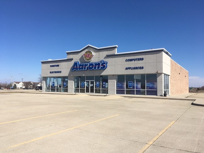
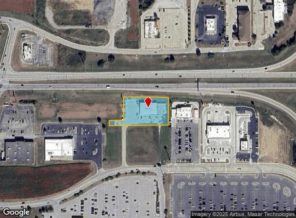
Property Record
1312 Fort Worth Way, Mattoon, IL 61938
NEARBY LISTINGS FOR SALE OR LEASE
Property Detail
1312 Fort Worth Way
Charleston-Mattoon, IL
Development Phase Ii
06-0-05133-002
LOT 401 OF THE RE-PLAT OF MCFALL SWORDS COMMERCIAL- RESIDENTIAL PHASE II BLOCK 03 LOT 04
Commercialnec
Coles
X
Illinois
17029C0280D
4,401
2024
1.20 AC
2024
Other Market Areas
001000
DEMOGRAPHICS near 1312 Fort Worth Way
1 Mile
3 Mile
5 Mile
2024 Total Population
420
12,055
19,193
2029 Population
413
11,820
18,790
Pop Growth 2024-2029
(1.67%)
(1.95%)
(2.10%)
Average Age
51
43
42
2024 Total Households
189
5,461
8,503
HH Growth 2024-2029
(1.59%)
(2.12%)
(2.27%)
Median Household Inc
$51,667
$42,532
$46,246
Avg Household Size
2.00
2.10
2.20
2024 Avg HH Vehicles
2.00
2.00
2.00
Median Home Value
$164,912
$87,333
$91,517
Median Year Built
1964
1959
1958
Nearby Places
Map Layers
Map Styles
 Street
 Aerial
- Restaurants
- Banks
- Shops
- Fitness
- Groceries
PUBLIC TRANSPORTATION
COMMUTER RAIL
Mattoon Amtrak Station (City of New Orleans - Amtrak, Illini - Amtrak, Saluki - Amtrak)
DRIVE
WALK
Distance
Mattoon Amtrak Station (City of New Orleans - Amtrak, Illini - Amtrak, Saluki - Amtrak)
7 min
2.9 mi
Freight Ports
Port Milwaukee
DRIVE
WALK
Distance
Port Milwaukee
306 min
266.9 mi
SALE & LEASE HISTORY
LISTING DATE
SALE/LEASE

Jan 31, 2018
For Sale
Nearby Properties
Address
Land Use
TOTAL SIZE
Lot Size
Zoning
Address
Land Use
TOTAL SIZE
Lot Size
Zoning
Address
Land Use
TOTAL SIZE
Lot Size
Zoning
199,970 SF
24.47 AC
Address
Land Use
TOTAL SIZE
Lot Size
Zoning
75,332 SF
6.48 AC
Address
Land Use
TOTAL SIZE
Lot Size
Zoning
24,943 SF
91.27 AC
Address
Land Use
TOTAL SIZE
Lot Size
Zoning
Address
Land Use
TOTAL SIZE
Lot Size
Zoning
0.92 AC
Address
Land Use
TOTAL SIZE
Lot Size
Zoning
208,184 SF
30.37 AC
Address
Land Use
TOTAL SIZE
Lot Size
Zoning
39,960 SF
1.95 AC
Address
Land Use
TOTAL SIZE
Lot Size
Zoning
Address
Land Use
TOTAL SIZE
Lot Size
Zoning
59,782 SF
6.79 AC
Address
Land Use
TOTAL SIZE
Lot Size
Zoning
95,068 SF
10.13 AC
Address
Land Use
TOTAL SIZE
Lot Size
Zoning
3,360 SF
5.96 AC
Address
Land Use
TOTAL SIZE
Lot Size
Zoning
9,888 SF
1.17 AC
Address
Land Use
TOTAL SIZE
Lot Size
Zoning
31,026 SF
34.80 AC
Address
Land Use
TOTAL SIZE
Lot Size
Zoning
9,644 SF
1.81 AC
Address
Land Use
TOTAL SIZE
Lot Size
Zoning
41,673 SF
5.40 AC
Address
Land Use
TOTAL SIZE
Lot Size
Zoning
Address
Land Use
TOTAL SIZE
Lot Size
Zoning
15,263 SF
2.80 AC
Address
Land Use
TOTAL SIZE
Lot Size
Zoning
2.61 AC
Address
Land Use
TOTAL SIZE
Lot Size
Zoning
230,400 SF
31.34 AC
Address
Land Use
TOTAL SIZE
Lot Size
Zoning
19,320 SF
1.44 AC
Address
Land Use
TOTAL SIZE
Lot Size
Zoning
38,486 SF
4.99 AC
Address
Land Use
TOTAL SIZE
Lot Size
Zoning
68,424 SF
5 AC
Address
Land Use
TOTAL SIZE
Lot Size
Zoning
171,500 SF
11.90 AC
Address
Land Use
TOTAL SIZE
Lot Size
Zoning
25,576 SF
6.60 AC
Address
Land Use
TOTAL SIZE
Lot Size
Zoning
38,414 SF
5.21 AC
Address
Land Use
TOTAL SIZE
Lot Size
Zoning
62,944 SF
0.80 AC
Address
Land Use
TOTAL SIZE
Lot Size
Zoning
27,534 SF
0.32 AC
Address
Land Use
TOTAL SIZE
Lot Size
Zoning
33,377 SF
6.20 AC
Address
Land Use
TOTAL SIZE
Lot Size
Zoning
5,264 SF
1.65 AC
The World's #1 Commercial Real Estate Marketplace
Connect with us
© 2026 CoStar Group
The information above has been obtained from sources believed reliable. While we do not doubt its accuracy we have not verified it and make no guarantee, warranty or representation about it. It is your responsibility to independently confirm its accuracy and completeness. Any projections, opinions, assumptions, or estimates used are for example only and do not represent the current or future performance of the property. The value of this transaction to you depends on tax and other factors which should be evaluated by your tax, financial, and legal advisors. You and your advisors should conduct a careful, independent investigation of the property to determine to your satisfaction the suitability of the property for your needs.