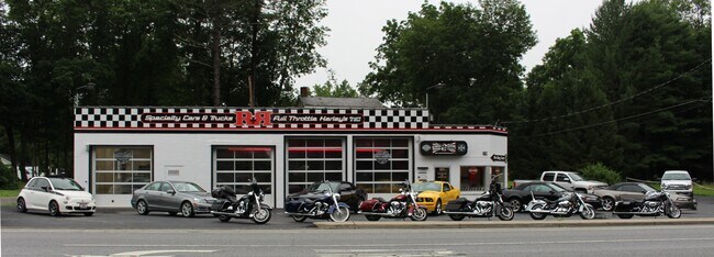
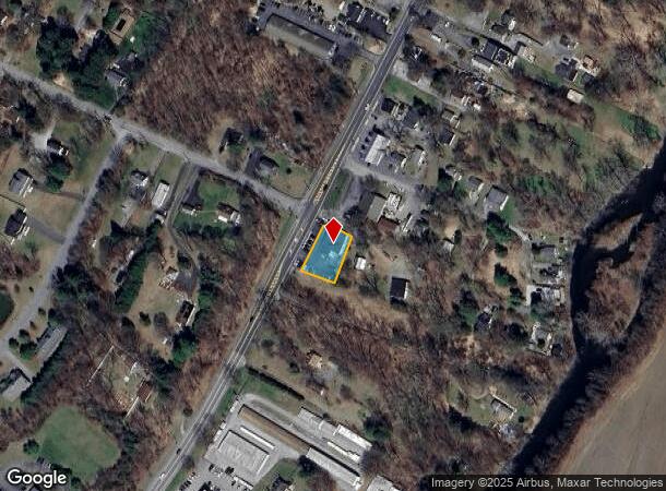
Property Record
1312 Route 44, Poughkeepsie, NY 12603
NEARBY LISTINGS FOR SALE OR LEASE
Property Detail
1312 Route 44
134400-6362-01-455989-0000
0.28 AC (S) 1065 0363
Autorepair
Dutchess
X
New York
36027C0377E
455
2025
0.28 AC
2024
Fishkill
130003
Westchester/So Connecticut
3,501 SF
Kiryas Joel-Poughkeepsie-Newburgh, NY
DEMOGRAPHICS near 1312 Route 44
1 Mile
3 Mile
5 Mile
2024 Total Population
2,413
17,309
76,949
2029 Population
2,406
17,374
77,039
Pop Growth 2024-2029
(0.29%)
+ 0.38%
+ 0.12%
Average Age
41
42
39
2024 Total Households
907
6,815
27,930
HH Growth 2024-2029
(0.44%)
+ 0.35%
+ 0.18%
Median Household Inc
$95,459
$85,274
$72,911
Avg Household Size
2.60
2.50
2.40
2024 Avg HH Vehicles
2.00
2.00
2.00
Median Home Value
$292,660
$327,337
$288,689
Median Year Built
1963
1975
1964
Nearby Places
Map Layers
Map Styles
 Street
 Aerial
- Restaurants
- Banks
- Shops
- Fitness
- Groceries
PUBLIC TRANSPORTATION
COMMUTER RAIL
Poughkeepsie Station (Hudson Line - Metro-North Commuter Railroad Company (Metro-North))
DRIVE
WALK
Distance
Poughkeepsie Station (Hudson Line - Metro-North Commuter Railroad Company (Metro-North))
11 min
6.4 mi
AIRPORT
New York Stewart International
DRIVE
WALK
Distance
New York Stewart International
45 min
29.7 mi
SALE & LEASE HISTORY
LISTING DATE
SALE/LEASE

Feb 04, 2023
For Sale
Nearby Properties
Address
Land Use
TOTAL SIZE
Lot Size
Zoning
Address
Land Use
TOTAL SIZE
Lot Size
Zoning
12,792 SF
130.16 AC
OI
Address
Land Use
TOTAL SIZE
Lot Size
Zoning
175,204 SF
4.50 AC
MHC
Address
Land Use
TOTAL SIZE
Lot Size
Zoning
121,040 SF
16.05 AC
OPD
Address
Land Use
TOTAL SIZE
Lot Size
Zoning
32,864 SF
22.85 AC
RM
Address
Land Use
TOTAL SIZE
Lot Size
Zoning
87,550 SF
30 AC
R20
Address
Land Use
TOTAL SIZE
Lot Size
Zoning
47,877 SF
13.50 AC
RM
Address
Land Use
TOTAL SIZE
Lot Size
Zoning
61,990 SF
12.97 AC
RM
Address
Land Use
TOTAL SIZE
Lot Size
Zoning
17,578 SF
60.60 AC
HR
Address
Land Use
TOTAL SIZE
Lot Size
Zoning
381,718 SF
58.30 AC
IH
Address
Land Use
TOTAL SIZE
Lot Size
Zoning
Address
Land Use
TOTAL SIZE
Lot Size
Zoning
21.98 AC
MDR
Address
Land Use
TOTAL SIZE
Lot Size
Zoning
Address
Land Use
TOTAL SIZE
Lot Size
Zoning
85,160 SF
20 AC
RFD
Address
Land Use
TOTAL SIZE
Lot Size
Zoning
Address
Land Use
TOTAL SIZE
Lot Size
Zoning
85,448 SF
26.20 AC
BH
Address
Land Use
TOTAL SIZE
Lot Size
Zoning
60,651 SF
1.76 AC
MHC
Address
Land Use
TOTAL SIZE
Lot Size
Zoning
19,622 SF
1.36 AC
MHC
Address
Land Use
TOTAL SIZE
Lot Size
Zoning
110,261 SF
61.27 AC
GB
Address
Land Use
TOTAL SIZE
Lot Size
Zoning
50,120 SF
3.33 AC
MHC
Address
Land Use
TOTAL SIZE
Lot Size
Zoning
49,752 SF
17.24 AC
MDR
Address
Land Use
TOTAL SIZE
Lot Size
Zoning
29,674 SF
19.06 AC
HR
Address
Land Use
TOTAL SIZE
Lot Size
Zoning
Address
Land Use
TOTAL SIZE
Lot Size
Zoning
96,001 SF
6.26 AC
H-PV
Address
Land Use
TOTAL SIZE
Lot Size
Zoning
65,818 SF
5.91 AC
RM
Address
Land Use
TOTAL SIZE
Lot Size
Zoning
85,756 SF
14.60 AC
BSC
Address
Land Use
TOTAL SIZE
Lot Size
Zoning
19,622 SF
1.20 AC
MHC
Address
Land Use
TOTAL SIZE
Lot Size
Zoning
43,368 SF
1.30 AC
MHC
Address
Land Use
TOTAL SIZE
Lot Size
Zoning
56,610 SF
6.97 AC
RM
Address
Land Use
TOTAL SIZE
Lot Size
Zoning
128,485 SF
27.17 AC
I
Address
Land Use
TOTAL SIZE
Lot Size
Zoning
26,850 SF
3.57 AC
MHC
The World's #1 Commercial Real Estate Marketplace
Connect with us
© 2026 CoStar Group
The information above has been obtained from sources believed reliable. While we do not doubt its accuracy we have not verified it and make no guarantee, warranty or representation about it. It is your responsibility to independently confirm its accuracy and completeness. Any projections, opinions, assumptions, or estimates used are for example only and do not represent the current or future performance of the property. The value of this transaction to you depends on tax and other factors which should be evaluated by your tax, financial, and legal advisors. You and your advisors should conduct a careful, independent investigation of the property to determine to your satisfaction the suitability of the property for your needs.