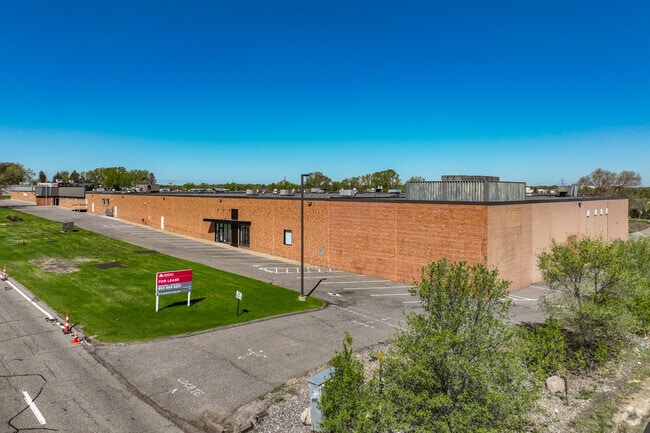
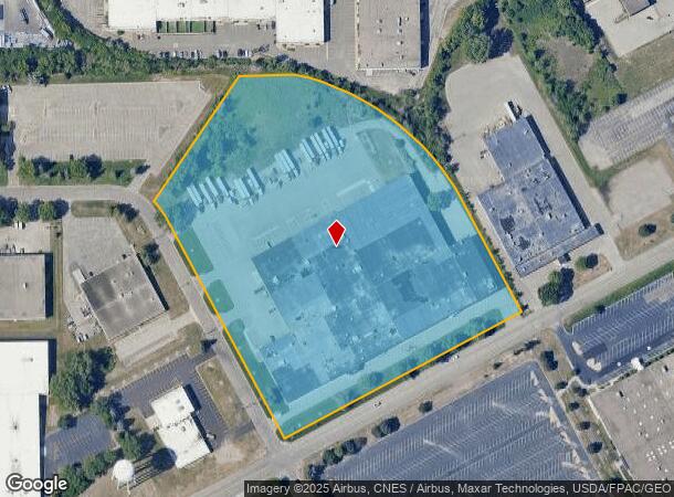
Property Record
13120 County Road 6, Minneapolis, MN 55441
Current Lease Availabilities
NEARBY LISTINGS FOR SALE OR LEASE
Property Detail
13120 County Road 6
Minneapolis-St. Paul-Bloomington, MN-WI
Minneapolis Industrial Park
27-118-22-42-0001
LOT 002 BLOCK 003 A MINNEAPOLIS INDUSTRIAL PARK COM AT A PT IN N LINE OF LOT 2 DIS 370 FT E FROM NW COR THOF TH S 15 FT TO SLY LINE OF SPUR TRACK SAID PT BEING THE ACTUAL PT OF BEG TH T IRREGULAR
Industrialgeneral
Hennepin
X
Minnesota
27053C0327F
2
2024
11.47 AC
2024
Northwest
026514
Minneapolis/St Paul
DEMOGRAPHICS near 13120 County Road 6
1 Mile
3 Mile
5 Mile
2024 Total Population
3,293
61,399
178,433
2029 Population
3,248
60,499
175,716
Pop Growth 2024-2029
(1.37%)
(1.47%)
(1.52%)
Average Age
43
42
42
2024 Total Households
1,256
26,510
74,579
HH Growth 2024-2029
(1.67%)
(1.55%)
(1.65%)
Median Household Inc
$114,884
$102,520
$103,016
Avg Household Size
2.50
2.20
2.30
2024 Avg HH Vehicles
2.00
2.00
2.00
Median Home Value
$377,631
$392,765
$382,494
Median Year Built
1976
1981
1979
Nearby Places
- Restaurants
- Banks
- Shops
- Fitness
- Groceries
PUBLIC TRANSPORTATION
COMMUTER RAIL
Target Field Station (Northstar Corridor - Northstar Commuter Rail)
DRIVE
WALK
Distance
Target Field Station (Northstar Corridor - Northstar Commuter Rail)
16 min
9.0 mi
AIRPORT
Minneapolis-St Paul International/Wold-Chamberlain
DRIVE
WALK
Distance
Minneapolis-St Paul International/Wold-Chamberlain
31 min
22.0 mi
Freight Ports
Port Milwaukee
DRIVE
WALK
Distance
Port Milwaukee
390 min
349.1 mi
Nearby Properties
Address
Land Use
TOTAL SIZE
Lot Size
Zoning
Address
Land Use
TOTAL SIZE
Lot Size
Zoning
35.53 AC
Address
Land Use
TOTAL SIZE
Lot Size
Zoning
324,564 SF
32.54 AC
PID
Address
Land Use
TOTAL SIZE
Lot Size
Zoning
18.27 AC
Address
Land Use
TOTAL SIZE
Lot Size
Zoning
16.32 AC
Address
Land Use
TOTAL SIZE
Lot Size
Zoning
20,710 SF
7.69 AC
PID
Address
Land Use
TOTAL SIZE
Lot Size
Zoning
20,710 SF
7.69 AC
PID
Address
Land Use
TOTAL SIZE
Lot Size
Zoning
6.47 AC
Address
Land Use
TOTAL SIZE
Lot Size
Zoning
19.46 AC
PUD
Address
Land Use
TOTAL SIZE
Lot Size
Zoning
202,718 SF
14.37 AC
PID
Address
Land Use
TOTAL SIZE
Lot Size
Zoning
Address
Land Use
TOTAL SIZE
Lot Size
Zoning
196,498 SF
13.13 AC
PID
Address
Land Use
TOTAL SIZE
Lot Size
Zoning
11.93 AC
PID
Address
Land Use
TOTAL SIZE
Lot Size
Zoning
Address
Land Use
TOTAL SIZE
Lot Size
Zoning
2.58 AC
Address
Land Use
TOTAL SIZE
Lot Size
Zoning
15.86 AC
Address
Land Use
TOTAL SIZE
Lot Size
Zoning
2.38 AC
Address
Land Use
TOTAL SIZE
Lot Size
Zoning
Address
Land Use
TOTAL SIZE
Lot Size
Zoning
40.17 AC
Address
Land Use
TOTAL SIZE
Lot Size
Zoning
Address
Land Use
TOTAL SIZE
Lot Size
Zoning
4.34 AC
Address
Land Use
TOTAL SIZE
Lot Size
Zoning
18.95 AC
Address
Land Use
TOTAL SIZE
Lot Size
Zoning
22.20 AC
Address
Land Use
TOTAL SIZE
Lot Size
Zoning
94,155 SF
2.06 AC
PUD
Address
Land Use
TOTAL SIZE
Lot Size
Zoning
10.57 AC
PID
Address
Land Use
TOTAL SIZE
Lot Size
Zoning
16.35 AC
Address
Land Use
TOTAL SIZE
Lot Size
Zoning
12.06 AC
PID
Address
Land Use
TOTAL SIZE
Lot Size
Zoning
2.69 AC
Address
Land Use
TOTAL SIZE
Lot Size
Zoning
14.36 AC
PID
Address
Land Use
TOTAL SIZE
Lot Size
Zoning
237,757 SF
7.12 AC
Address
Land Use
TOTAL SIZE
Lot Size
Zoning
198,528 SF
6.05 AC
The World's #1 Commercial Real Estate Marketplace
Connect with us
© 2025 CoStar Group
The information above has been obtained from sources believed reliable. While we do not doubt its accuracy we have not verified it and make no guarantee, warranty or representation about it. It is your responsibility to independently confirm its accuracy and completeness. Any projections, opinions, assumptions, or estimates used are for example only and do not represent the current or future performance of the property. The value of this transaction to you depends on tax and other factors which should be evaluated by your tax, financial, and legal advisors. You and your advisors should conduct a careful, independent investigation of the property to determine to your satisfaction the suitability of the property for your needs.