Property Record
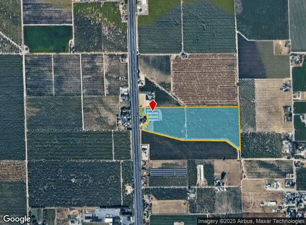
13120 S Highway 99 Rd, Manteca, CA 95336
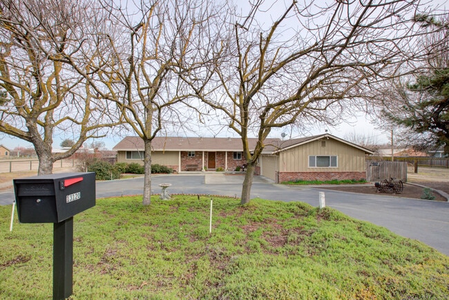
This Property Is For Sale
NEARBY LISTINGS FOR SALE OR LEASE
Property Detail
13120 S Highway 99 Rd
206-030-21
PARCEL MAPS 4 PG 11
Orchard
San Joaquin
X
California
06077C0630F
42.29 AC
2025
Tracy/Manteca
2025
Stockton/Modesto
005110
Stockton-Lodi, CA
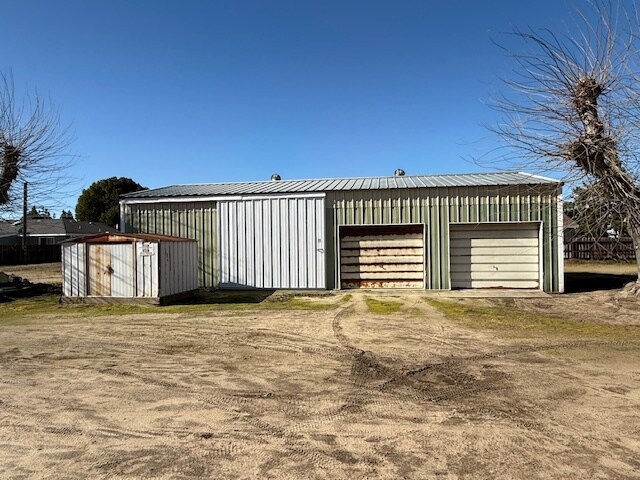
1,665 SF
DEMOGRAPHICS near 13120 S Highway 99 Rd
1 Mile
3 Mile
5 Mile
2024 Total Population
1,030
43,313
101,925
2029 Population
1,071
45,663
106,958
Pop Growth 2024-2029
+ 3.98%
+ 5.43%
+ 4.94%
Average Age
41
41
39
2024 Total Households
338
14,559
31,848
HH Growth 2024-2029
+ 3.85%
+ 5.55%
+ 5.17%
Median Household Inc
$92,773
$90,967
$86,892
Avg Household Size
3.00
2.90
3.10
2024 Avg HH Vehicles
3.00
2.00
2.00
Median Home Value
$702,381
$472,754
$465,421
Median Year Built
1975
1987
1989
Nearby Places
Map Layers
Map Styles
 Street
 Aerial
- Restaurants
- Banks
- Shops
- Fitness
- Groceries
PUBLIC TRANSPORTATION
COMMUTER RAIL
Lathrop/Manteca (ACE Train - Altamont Commuter Express (ACE), Altamont Corridor Express - Altamont Commuter Express (ACE))
DRIVE
WALK
Distance
Lathrop/Manteca (ACE Train - Altamont Commuter Express (ACE), Altamont Corridor Express - Altamont Commuter Express (ACE))
13 min
6.6 mi
AIRPORT
Stockton Metro
DRIVE
WALK
Distance
Stockton Metro
11 min
5.1 mi
Freight Ports
Port of Stockton
DRIVE
WALK
Distance
Port of Stockton
20 min
11.7 mi
Nearby Properties
Address
Land Use
TOTAL SIZE
Lot Size
Zoning
Address
Land Use
TOTAL SIZE
Lot Size
Zoning
730,300 SF
41.44 AC
Address
Land Use
TOTAL SIZE
Lot Size
Zoning
600 SF
19.12 AC
Address
Land Use
TOTAL SIZE
Lot Size
Zoning
746,790 SF
39.23 AC
M2
Address
Land Use
TOTAL SIZE
Lot Size
Zoning
830,175 SF
46.57 AC
IG
Address
Land Use
TOTAL SIZE
Lot Size
Zoning
Address
Land Use
TOTAL SIZE
Lot Size
Zoning
16.02 AC
Address
Land Use
TOTAL SIZE
Lot Size
Zoning
19,912 SF
6.49 AC
C1
Address
Land Use
TOTAL SIZE
Lot Size
Zoning
404,657 SF
24.89 AC
AG40
Address
Land Use
TOTAL SIZE
Lot Size
Zoning
110,000 SF
15.10 AC
Address
Land Use
TOTAL SIZE
Lot Size
Zoning
Address
Land Use
TOTAL SIZE
Lot Size
Zoning
85,933 SF
3.32 AC
Address
Land Use
TOTAL SIZE
Lot Size
Zoning
157 AC
AG40
Address
Land Use
TOTAL SIZE
Lot Size
Zoning
26,141 SF
2.80 AC
Address
Land Use
TOTAL SIZE
Lot Size
Zoning
77,245 SF
3.46 AC
Address
Land Use
TOTAL SIZE
Lot Size
Zoning
42,371 SF
4.23 AC
Address
Land Use
TOTAL SIZE
Lot Size
Zoning
91,135 SF
6.09 AC
AG40
Address
Land Use
TOTAL SIZE
Lot Size
Zoning
24.44 AC
Address
Land Use
TOTAL SIZE
Lot Size
Zoning
2,363 SF
28.66 AC
AG40
Address
Land Use
TOTAL SIZE
Lot Size
Zoning
102,404 SF
5.38 AC
Address
Land Use
TOTAL SIZE
Lot Size
Zoning
87,150 SF
5.94 AC
Address
Land Use
TOTAL SIZE
Lot Size
Zoning
61,236 SF
5.51 AC
Address
Land Use
TOTAL SIZE
Lot Size
Zoning
103,240 SF
3.46 AC
Address
Land Use
TOTAL SIZE
Lot Size
Zoning
30,610 SF
7.52 AC
Address
Land Use
TOTAL SIZE
Lot Size
Zoning
23.21 AC
Address
Land Use
TOTAL SIZE
Lot Size
Zoning
71,136 SF
3.09 AC
Address
Land Use
TOTAL SIZE
Lot Size
Zoning
35,283 SF
3.22 AC
Address
Land Use
TOTAL SIZE
Lot Size
Zoning
12,300 SF
6.52 AC
Address
Land Use
TOTAL SIZE
Lot Size
Zoning
60,150 SF
4.69 AC
Address
Land Use
TOTAL SIZE
Lot Size
Zoning
114,000 SF
6.35 AC
Address
Land Use
TOTAL SIZE
Lot Size
Zoning
6.04 AC
The World's #1 Commercial Real Estate Marketplace
Connect with us
© 2025 CoStar Group
The information above has been obtained from sources believed reliable. While we do not doubt its accuracy we have not verified it and make no guarantee, warranty or representation about it. It is your responsibility to independently confirm its accuracy and completeness. Any projections, opinions, assumptions, or estimates used are for example only and do not represent the current or future performance of the property. The value of this transaction to you depends on tax and other factors which should be evaluated by your tax, financial, and legal advisors. You and your advisors should conduct a careful, independent investigation of the property to determine to your satisfaction the suitability of the property for your needs.