Property Record
1313 N White St, Wake Forest, NC 27587

NEARBY LISTINGS FOR SALE OR LEASE
Property Detail
1313 N White St
Raleigh-Cary, NC
James M Adams Surv
1851.01-08-9042-000
LO2 JAMES M ADAMS BM2000-1059
Agriculturalland
Wake
X
North Carolina
3720185100L
2
2025
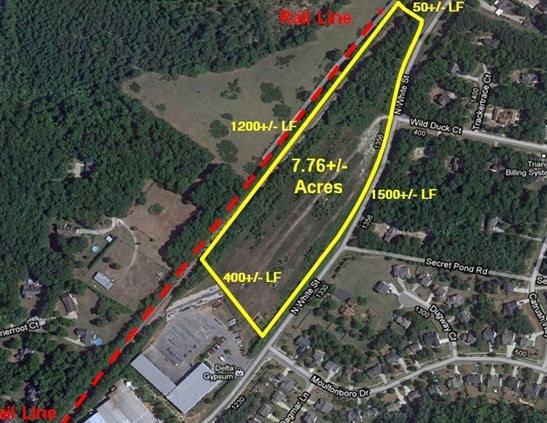
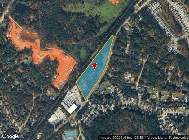
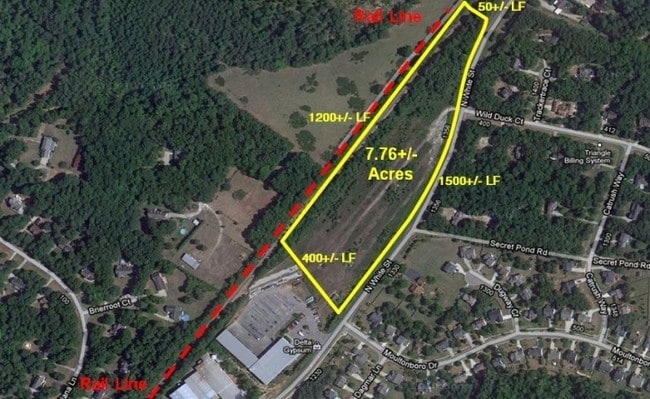
7.76 AC
2025
Route 1
054206
Raleigh/Durham
512 SF
DEMOGRAPHICS near 1313 N White St
1 mile
3 mile
5 mile
2024 Total Population
6,062
36,591
86,725
2029 Population
6,822
41,203
97,674
Pop Growth 2024-2029
+ 12.54%
+ 12.60%
+ 12.62%
Average Age
40
39
39
2024 Total Households
2,254
13,224
31,465
HH Growth 2024-2029
+ 12.91%
+ 12.68%
+ 12.64%
Median Household Inc
$90,394
$100,250
$107,190
Avg Household Size
2.50
2.70
2.70
2024 Avg HH Vehicles
2.00
2.00
2.00
Median Home Value
$394,532
$356,254
$371,588
Median Year Built
1999
2003
2006
Nearby Places
Map Layers
Map Styles
 Street
 Aerial
Transit
 Traffic
 Biking
Places
Listings with unknown addresses are not visible on the map
- Restaurants
- Banks
- Shops
- Fitness
- Groceries
PUBLIC TRANSPORTATION
AIRPORT
Raleigh-Durham International
Drive
Walk
Distance
Raleigh-Durham International
37 min
23.6 mi
SALE & LEASE HISTORY
LISTING DATE
SALE/LEASE

Sep 24, 2016
For Sale
Nov 24, 2020
For Sale
May 25, 2022
For Sale
Mar 11, 2021
For Sale
Apr 02, 2019
For Sale
Nearby Properties
Address
Land Use
TOTAL SIZE
Lot Size
Zoning
Address
Land Use
TOTAL SIZE
Lot Size
Zoning
378,421 SF
19.06 AC
RMX
Address
Land Use
TOTAL SIZE
Lot Size
Zoning
442,480 SF
52.02 AC
GR3
Address
Land Use
TOTAL SIZE
Lot Size
Zoning
283,795 SF
31.33 AC
ICD
Address
Land Use
TOTAL SIZE
Lot Size
Zoning
159,584 SF
67.12 AC
FCO GB
Address
Land Use
TOTAL SIZE
Lot Size
Zoning
136,644 SF
4.38 AC
RMX
Address
Land Use
TOTAL SIZE
Lot Size
Zoning
186,546 SF
6.84 AC
RMX
Address
Land Use
TOTAL SIZE
Lot Size
Zoning
143,060 SF
7.19 AC
RMX
Address
Land Use
TOTAL SIZE
Lot Size
Zoning
154,602 SF
40 AC
ICD
Address
Land Use
TOTAL SIZE
Lot Size
Zoning
84,528 SF
14.44 AC
NB
Address
Land Use
TOTAL SIZE
Lot Size
Zoning
97,878 SF
26.85 AC
GR5
Address
Land Use
TOTAL SIZE
Lot Size
Zoning
111,616 SF
4.69 AC
NMX
Address
Land Use
TOTAL SIZE
Lot Size
Zoning
170,100 SF
15.41 AC
FCO GB
Address
Land Use
TOTAL SIZE
Lot Size
Zoning
106,593 SF
15.32 AC
HB
Address
Land Use
TOTAL SIZE
Lot Size
Zoning
107,082 SF
4.17 AC
RMX
Address
Land Use
TOTAL SIZE
Lot Size
Zoning
91,233 SF
11.04 AC
GR10
Address
Land Use
TOTAL SIZE
Lot Size
Zoning
88,053 SF
12.16 AC
GR10
Address
Land Use
TOTAL SIZE
Lot Size
Zoning
103,310 SF
6.29 AC
RMX
Address
Land Use
TOTAL SIZE
Lot Size
Zoning
101,307 SF
21 AC
HB
Address
Land Use
TOTAL SIZE
Lot Size
Zoning
117,680 SF
11.99 AC
GR10
Address
Land Use
TOTAL SIZE
Lot Size
Zoning
160,525 SF
20.02 AC
IND
Address
Land Use
TOTAL SIZE
Lot Size
Zoning
58,211 SF
6.96 AC
NMX
Address
Land Use
TOTAL SIZE
Lot Size
Zoning
61,138 SF
36.70 AC
GR3
Address
Land Use
TOTAL SIZE
Lot Size
Zoning
364,500 SF
30.25 AC
IND
Address
Land Use
TOTAL SIZE
Lot Size
Zoning
77,343 SF
14.12 AC
GR5
Address
Land Use
TOTAL SIZE
Lot Size
Zoning
117,037 SF
13.88 AC
GR10
Address
Land Use
TOTAL SIZE
Lot Size
Zoning
83,797 SF
11.25 AC
HB
Address
Land Use
TOTAL SIZE
Lot Size
Zoning
105,912 SF
8.44 AC
GR10
Address
Land Use
TOTAL SIZE
Lot Size
Zoning
101,523 SF
2.82 AC
HB
Address
Land Use
TOTAL SIZE
Lot Size
Zoning
92,980 SF
145.72 AC
RMX
Address
Land Use
TOTAL SIZE
Lot Size
Zoning
161.31 AC
HB
The World's #1 Commercial Real Estate Marketplace
Connect with us
© 2026 CoStar Group
The information above has been obtained from sources believed reliable. While we do not doubt its accuracy we have not verified it and make no guarantee, warranty or representation about it. It is your responsibility to independently confirm its accuracy and completeness. Any projections, opinions, assumptions, or estimates used are for example only and do not represent the current or future performance of the property. The value of this transaction to you depends on tax and other factors which should be evaluated by your tax, financial, and legal advisors. You and your advisors should conduct a careful, independent investigation of the property to determine to your satisfaction the suitability of the property for your needs.