Property Record
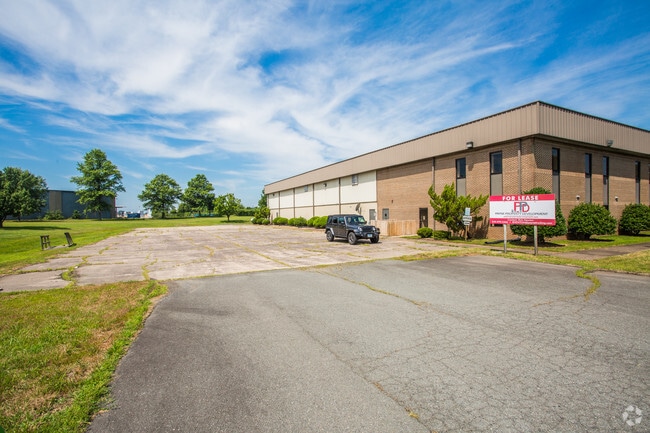
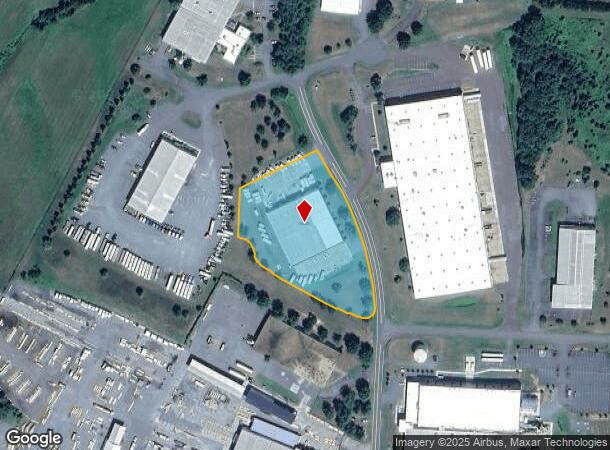
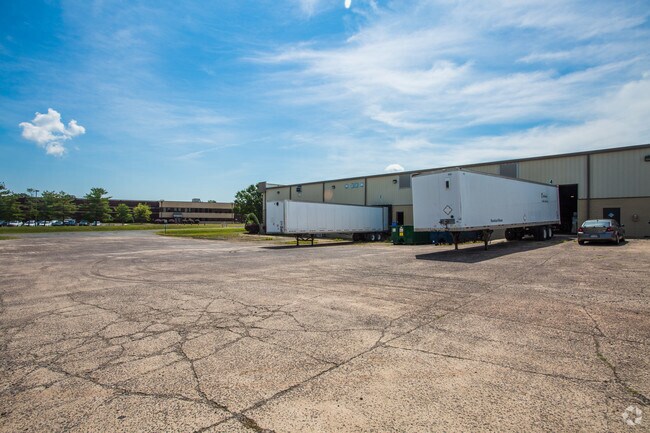
13142 Airpark Dr, Elkwood, VA 22718

NEARBY LISTINGS FOR SALE OR LEASE
-
-
View all Elkwood listings for sale on LoopNet.com
Property Detail
13142 Airpark Dr
Washington-Arlington-Alexandria, DC-VA-MD-WV
079
34-B-1-11
CULPEPER INDUSTRIAL AIRPK LOT D-1A PLAT CAB 3/120-121
Commercialnec
Culpeper
X
Virginia
51061C0415D
d
2024
3.03 AC
2025
Suburban Virginia Area
930400
Other Market Areas
21,875 SF
DEMOGRAPHICS near 13142 Airpark Dr
1 Mile
3 Mile
5 Mile
2024 Total Population
79
2,287
6,379
2029 Population
86
2,423
6,779
Pop Growth 2024-2029
+ 8.86%
+ 5.95%
+ 6.27%
Average Age
42
37
38
2024 Total Households
29
783
2,175
HH Growth 2024-2029
+ 6.90%
+ 6.00%
+ 6.44%
Median Household Inc
$79,167
$82,632
$85,694
Avg Household Size
2.70
2.90
2.90
2024 Avg HH Vehicles
3.00
2.00
2.00
Median Home Value
$350,000
$321,486
$336,956
Median Year Built
1988
1986
1986
Nearby Places
- Restaurants
- Banks
- Shops
- Fitness
- Groceries
PUBLIC TRANSPORTATION
COMMUTER RAIL
Culpeper Amtrak Station (Cardinal - Amtrak, Crescent - Amtrak, Northeast Regional - Amtrak)
DRIVE
WALK
Distance
Culpeper Amtrak Station (Cardinal - Amtrak, Crescent - Amtrak, Northeast Regional - Amtrak)
16 min
9.2 mi
Freight Ports
Virginia Port Authority - Richmond
DRIVE
WALK
Distance
Virginia Port Authority - Richmond
124 min
93.9 mi
SALE & LEASE HISTORY
LISTING DATE
SALE/LEASE

Sep 25, 2016
For Lease
Sep 24, 2016
For Sale
Mar 31, 2017
For Sale
Nearby Properties
Address
Land Use
TOTAL SIZE
Lot Size
Zoning
Address
Land Use
TOTAL SIZE
Lot Size
Zoning
71,126 SF
8.06 AC
RES, 4 DWE
Address
Land Use
TOTAL SIZE
Lot Size
Zoning
173,404 SF
12.12 AC
HIPB
Address
Land Use
TOTAL SIZE
Lot Size
Zoning
113,494 SF
35 AC
HI
Address
Land Use
TOTAL SIZE
Lot Size
Zoning
150,400 SF
10.73 AC
HI
Address
Land Use
TOTAL SIZE
Lot Size
Zoning
25,848 SF
0.99 AC
R1 RES SIN
Address
Land Use
TOTAL SIZE
Lot Size
Zoning
1,800 SF
6.01 AC
HI
Address
Land Use
TOTAL SIZE
Lot Size
Zoning
6,000 SF
9.23 AC
LI
Address
Land Use
TOTAL SIZE
Lot Size
Zoning
3,628 SF
27.50 AC
LI
Address
Land Use
TOTAL SIZE
Lot Size
Zoning
12.87 AC
A1
Address
Land Use
TOTAL SIZE
Lot Size
Zoning
15,442 SF
6.12 AC
HI
Address
Land Use
TOTAL SIZE
Lot Size
Zoning
1,200 SF
214.15 AC
AGRICULTUR
Address
Land Use
TOTAL SIZE
Lot Size
Zoning
30,625 SF
10.56 AC
HI
Address
Land Use
TOTAL SIZE
Lot Size
Zoning
42,059 SF
5.51 AC
HI
Address
Land Use
TOTAL SIZE
Lot Size
Zoning
7,800 SF
5.71 AC
LI
Address
Land Use
TOTAL SIZE
Lot Size
Zoning
33,120 SF
3.65 AC
HI
Address
Land Use
TOTAL SIZE
Lot Size
Zoning
30,250 SF
6.78 AC
HI
Address
Land Use
TOTAL SIZE
Lot Size
Zoning
40,100 SF
5.87 AC
HI
Address
Land Use
TOTAL SIZE
Lot Size
Zoning
24,000 SF
8.59 AC
HI
Address
Land Use
TOTAL SIZE
Lot Size
Zoning
14,945 SF
13.48 AC
LI
Address
Land Use
TOTAL SIZE
Lot Size
Zoning
7.19 AC
HILI
Address
Land Use
TOTAL SIZE
Lot Size
Zoning
6,860 SF
3 AC
A1
Address
Land Use
TOTAL SIZE
Lot Size
Zoning
12,620 SF
8.07 AC
R2
Address
Land Use
TOTAL SIZE
Lot Size
Zoning
9,556 SF
1.25 AC
R1 RES SIN
Address
Land Use
TOTAL SIZE
Lot Size
Zoning
35,226 SF
3.20 AC
LI
Address
Land Use
TOTAL SIZE
Lot Size
Zoning
6,684 SF
4 AC
HI
Address
Land Use
TOTAL SIZE
Lot Size
Zoning
9,236 SF
0.45 AC
R3 RES TNH
Address
Land Use
TOTAL SIZE
Lot Size
Zoning
7,196 SF
1.93 AC
RES, 4 DWE
Address
Land Use
TOTAL SIZE
Lot Size
Zoning
82.23 AC
A1
Address
Land Use
TOTAL SIZE
Lot Size
Zoning
8,094 SF
3.82 AC
RES, 1 DWE
The World's #1 Commercial Real Estate Marketplace
Connect with us
© 2025 CoStar Group
The information above has been obtained from sources believed reliable. While we do not doubt its accuracy we have not verified it and make no guarantee, warranty or representation about it. It is your responsibility to independently confirm its accuracy and completeness. Any projections, opinions, assumptions, or estimates used are for example only and do not represent the current or future performance of the property. The value of this transaction to you depends on tax and other factors which should be evaluated by your tax, financial, and legal advisors. You and your advisors should conduct a careful, independent investigation of the property to determine to your satisfaction the suitability of the property for your needs.