Property Record
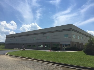
1315 Cedar Grove Rd, Shepherdsville, KY 40165


NEARBY LISTINGS FOR SALE OR LEASE
Property Detail
1315 Cedar Grove Rd
Louisville-Jefferson County, KY-IN
Cedar Grove Industrial Park
399680
LT 6A CEDAR GROVE INDUSTRIAL PK MINOR PL
Commercialnec
Bullitt
AE
Kentucky
21029C0177G
6a
2024
3.91 AC
2024
Bullitt County
021103
Louisville
DEMOGRAPHICS near 1315 Cedar Grove Rd
1 Mile
3 Mile
5 Mile
2024 Total Population
459
17,018
27,705
2029 Population
481
17,737
28,969
Pop Growth 2024-2029
+ 4.79%
+ 4.22%
+ 4.56%
Average Age
40
39
40
2024 Total Households
183
6,535
10,561
HH Growth 2024-2029
+ 4.37%
+ 4.10%
+ 4.48%
Median Household Inc
$36,346
$61,361
$63,000
Avg Household Size
2.50
2.60
2.60
2024 Avg HH Vehicles
2.00
2.00
2.00
Median Home Value
$196,341
$180,182
$190,207
Median Year Built
1979
1993
1991
Nearby Places
Map Layers
Map Styles
 Street
 Aerial
- Restaurants
- Banks
- Shops
- Fitness
- Groceries
PUBLIC TRANSPORTATION
AIRPORT
Louisville Muhammad Ali International
DRIVE
WALK
Distance
Louisville Muhammad Ali International
23 min
16.2 mi
Freight Ports
Port of Toledo
DRIVE
WALK
Distance
Port of Toledo
375 min
323.3 mi
SALE & LEASE HISTORY
LISTING DATE
SALE/LEASE

Sep 25, 2016
For Lease
Sep 24, 2016
For Sale
Feb 28, 2019
For Lease
Nearby Properties
Address
Land Use
TOTAL SIZE
Lot Size
Zoning
Address
Land Use
TOTAL SIZE
Lot Size
Zoning
Address
Land Use
TOTAL SIZE
Lot Size
Zoning
Address
Land Use
TOTAL SIZE
Lot Size
Zoning
936,000 SF
51.74 AC
Address
Land Use
TOTAL SIZE
Lot Size
Zoning
Address
Land Use
TOTAL SIZE
Lot Size
Zoning
Address
Land Use
TOTAL SIZE
Lot Size
Zoning
38.03 AC
Address
Land Use
TOTAL SIZE
Lot Size
Zoning
29.43 AC
Address
Land Use
TOTAL SIZE
Lot Size
Zoning
59.47 AC
Address
Land Use
TOTAL SIZE
Lot Size
Zoning
Address
Land Use
TOTAL SIZE
Lot Size
Zoning
Address
Land Use
TOTAL SIZE
Lot Size
Zoning
52.61 AC
Address
Land Use
TOTAL SIZE
Lot Size
Zoning
38.20 AC
Address
Land Use
TOTAL SIZE
Lot Size
Zoning
33.96 AC
Address
Land Use
TOTAL SIZE
Lot Size
Zoning
32.26 AC
Address
Land Use
TOTAL SIZE
Lot Size
Zoning
42.39 AC
Address
Land Use
TOTAL SIZE
Lot Size
Zoning
Address
Land Use
TOTAL SIZE
Lot Size
Zoning
Address
Land Use
TOTAL SIZE
Lot Size
Zoning
Address
Land Use
TOTAL SIZE
Lot Size
Zoning
Address
Land Use
TOTAL SIZE
Lot Size
Zoning
29.46 AC
Address
Land Use
TOTAL SIZE
Lot Size
Zoning
40.82 AC
Address
Land Use
TOTAL SIZE
Lot Size
Zoning
Address
Land Use
TOTAL SIZE
Lot Size
Zoning
Address
Land Use
TOTAL SIZE
Lot Size
Zoning
20.96 AC
Address
Land Use
TOTAL SIZE
Lot Size
Zoning
Address
Land Use
TOTAL SIZE
Lot Size
Zoning
400,260 SF
32.97 AC
Address
Land Use
TOTAL SIZE
Lot Size
Zoning
25.85 AC
Address
Land Use
TOTAL SIZE
Lot Size
Zoning
27.78 AC
Address
Land Use
TOTAL SIZE
Lot Size
Zoning
Address
Land Use
TOTAL SIZE
Lot Size
Zoning
The World's #1 Commercial Real Estate Marketplace
Connect with us
© 2025 CoStar Group
The information above has been obtained from sources believed reliable. While we do not doubt its accuracy we have not verified it and make no guarantee, warranty or representation about it. It is your responsibility to independently confirm its accuracy and completeness. Any projections, opinions, assumptions, or estimates used are for example only and do not represent the current or future performance of the property. The value of this transaction to you depends on tax and other factors which should be evaluated by your tax, financial, and legal advisors. You and your advisors should conduct a careful, independent investigation of the property to determine to your satisfaction the suitability of the property for your needs.