Property Record
1315 Gillespie St, Fayetteville, NC 28306

This Property Is For Sale
NEARBY LISTINGS FOR SALE OR LEASE
Property Detail
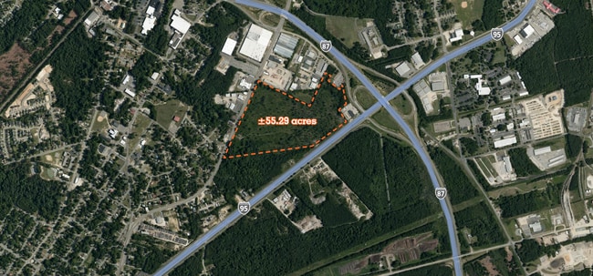
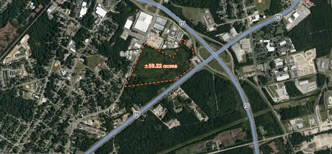
1315 Gillespie St
Fayetteville, NC
Gillespie Street
0436-46-8434
59.22 ACS LD
Commercialacreage
Cumberland
X
North Carolina
3720043600J
8434
2022
59.22 AC
2024
Southwest Fayetteville
001603
Fayetteville
DEMOGRAPHICS near 1315 Gillespie St
1 Mile
3 Mile
5 Mile
2024 Total Population
2,428
30,666
92,063
2029 Population
2,495
31,014
92,415
Pop Growth 2024-2029
+ 2.76%
+ 1.13%
+ 0.38%
Average Age
39
39
38
2024 Total Households
1,027
13,472
38,001
HH Growth 2024-2029
+ 2.73%
+ 1.08%
+ 0.38%
Median Household Inc
$30,422
$44,068
$46,617
Avg Household Size
2.30
2.20
2.30
2024 Avg HH Vehicles
1.00
1.00
2.00
Median Home Value
$103,297
$167,751
$150,481
Median Year Built
1977
1973
1976
Nearby Places
Map Layers
Map Styles
 Street
 Aerial
- Restaurants
- Banks
- Shops
- Fitness
- Groceries
PUBLIC TRANSPORTATION
COMMUTER RAIL
Fayetteville Amtrak Station (Palmetto - Amtrak, Silver Meteor - Amtrak)
DRIVE
WALK
Distance
Fayetteville Amtrak Station (Palmetto - Amtrak, Silver Meteor - Amtrak)
4 min
1.9 mi
AIRPORT
Fayetteville Regional/Grannis Field
DRIVE
WALK
Distance
Fayetteville Regional/Grannis Field
8 min
4.2 mi
Freight Ports
Port of Wilmington
DRIVE
WALK
Distance
Port of Wilmington
126 min
90.1 mi
Nearby Properties
Address
Land Use
TOTAL SIZE
Lot Size
Zoning
Address
Land Use
TOTAL SIZE
Lot Size
Zoning
182,282 SF
38.72 AC
OI
Address
Land Use
TOTAL SIZE
Lot Size
Zoning
2,193 SF
133.52 AC
MR5
Address
Land Use
TOTAL SIZE
Lot Size
Zoning
46,110 SF
25.72 AC
OI
Address
Land Use
TOTAL SIZE
Lot Size
Zoning
47,832 SF
43.28 AC
CC
Address
Land Use
TOTAL SIZE
Lot Size
Zoning
91,620 SF
9.67 AC
CC
Address
Land Use
TOTAL SIZE
Lot Size
Zoning
1,377 SF
20.14 AC
MR5-MIXED
Address
Land Use
TOTAL SIZE
Lot Size
Zoning
4,947 SF
937.13 AC
MA
Address
Land Use
TOTAL SIZE
Lot Size
Zoning
11,894 SF
8.39 AC
DTCZ
Address
Land Use
TOTAL SIZE
Lot Size
Zoning
37,786 SF
9.55 AC
CC
Address
Land Use
TOTAL SIZE
Lot Size
Zoning
28,107 SF
34.33 AC
HI
Address
Land Use
TOTAL SIZE
Lot Size
Zoning
6,670 SF
7.11 AC
CC
Address
Land Use
TOTAL SIZE
Lot Size
Zoning
1 AC
DTCZ
Address
Land Use
TOTAL SIZE
Lot Size
Zoning
1 AC
DTCZ-DOWNT
Address
Land Use
TOTAL SIZE
Lot Size
Zoning
191,495 SF
21.41 AC
CC
Address
Land Use
TOTAL SIZE
Lot Size
Zoning
27,825 SF
1.67 AC
DT
Address
Land Use
TOTAL SIZE
Lot Size
Zoning
26,818 SF
OI-OFFICE
Address
Land Use
TOTAL SIZE
Lot Size
Zoning
104,350 SF
23.28 AC
CC
Address
Land Use
TOTAL SIZE
Lot Size
Zoning
4,690 SF
11.13 AC
MR5
Address
Land Use
TOTAL SIZE
Lot Size
Zoning
1,064 SF
15.55 AC
MR5
Address
Land Use
TOTAL SIZE
Lot Size
Zoning
4,602 SF
29.92 AC
MR5
Address
Land Use
TOTAL SIZE
Lot Size
Zoning
65,113 SF
28.39 AC
SF6
Address
Land Use
TOTAL SIZE
Lot Size
Zoning
4,141 SF
11.72 AC
MR5
Address
Land Use
TOTAL SIZE
Lot Size
Zoning
47,279 SF
19.56 AC
LC
Address
Land Use
TOTAL SIZE
Lot Size
Zoning
40,786 SF
3.80 AC
DT
Address
Land Use
TOTAL SIZE
Lot Size
Zoning
9,736 SF
3.40 AC
CC
Address
Land Use
TOTAL SIZE
Lot Size
Zoning
2,860 SF
16.90 AC
SF10
Address
Land Use
TOTAL SIZE
Lot Size
Zoning
49.27 AC
MP-PLND IN
Address
Land Use
TOTAL SIZE
Lot Size
Zoning
74,169 SF
3.90 AC
DT
Address
Land Use
TOTAL SIZE
Lot Size
Zoning
10,493 SF
4.62 AC
CC
Address
Land Use
TOTAL SIZE
Lot Size
Zoning
18,034 SF
4.28 AC
CC-COMMUNI
The World's #1 Commercial Real Estate Marketplace
Connect with us
© 2026 CoStar Group
The information above has been obtained from sources believed reliable. While we do not doubt its accuracy we have not verified it and make no guarantee, warranty or representation about it. It is your responsibility to independently confirm its accuracy and completeness. Any projections, opinions, assumptions, or estimates used are for example only and do not represent the current or future performance of the property. The value of this transaction to you depends on tax and other factors which should be evaluated by your tax, financial, and legal advisors. You and your advisors should conduct a careful, independent investigation of the property to determine to your satisfaction the suitability of the property for your needs.