Property Record
1315 Main St, Willimantic, CT 06226
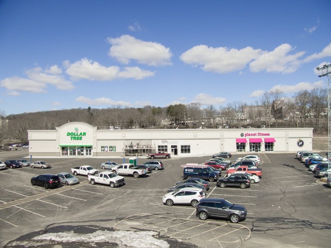

Property Detail
1315 Main St
WIND-001103-000012-000041A-D000000
Southeastern Ct
Commercialbuilding
Connecticut
B2
41-1
2025
4.06 AC
2025
Windham County
800300
Hartford
48,770 SF
Willimantic, CT
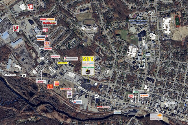
NEARBY LISTINGS FOR SALE OR LEASE
DEMOGRAPHICS near 1315 Main St
1 mile
3 mile
5 mile
2025 Total Population
10,081
26,587
37,640
2030 Population
10,283
26,961
38,213
Pop Growth 2025-2030
+ 2.00%
+ 1.41%
+ 1.52%
Average Age
34
37
39
2025 Total Households
3,086
9,796
14,210
HH Growth 2025-2030
+ 2.50%
+ 1.49%
+ 1.58%
Median Household Inc
$38,856
$51,727
$65,685
Avg Household Size
2.40
2.40
2.40
2025 Avg HH Vehicles
1.00
2.00
2.00
Median Home Value
$184,741
$232,714
$272,690
Median Year Built
1958
1962
1967
Nearby Places
Map Layers
Map Styles
 Street
 Aerial
Transit
 Traffic
 Biking
Places
Listings with unknown addresses are not visible on the map
- Restaurants
- Banks
- Shops
- Fitness
- Groceries
PUBLIC TRANSPORTATION
AIRPORT
Bradley International
Drive
Walk
Distance
Bradley International
63 min
41.6 mi
Freight Ports
Port of Davisville, RI
Drive
Walk
Distance
Port of Davisville, RI
86 min
63.4 mi
SALE & LEASE HISTORY
LISTING DATE
SALE/LEASE

Nov 19, 2019
For Sale
Feb 18, 2019
For Sale
Feb 03, 2017
For Lease
Dec 02, 2025
For Lease
Aug 02, 2023
For Lease
Apr 02, 2019
For Sale
Nearby Properties
Address
Land Use
TOTAL SIZE
Lot Size
Zoning
Address
Land Use
TOTAL SIZE
Lot Size
Zoning
14.62 AC
B4
Address
Land Use
TOTAL SIZE
Lot Size
Zoning
33,366 SF
R6
Address
Land Use
TOTAL SIZE
Lot Size
Zoning
145,144 SF
R6
Address
Land Use
TOTAL SIZE
Lot Size
Zoning
14.50 AC
R20
Address
Land Use
TOTAL SIZE
Lot Size
Zoning
111,757 SF
6.74 AC
RL
Address
Land Use
TOTAL SIZE
Lot Size
Zoning
90,450 SF
R6
Address
Land Use
TOTAL SIZE
Lot Size
Zoning
73,691 SF
R6
Address
Land Use
TOTAL SIZE
Lot Size
Zoning
99,139 SF
R6
Address
Land Use
TOTAL SIZE
Lot Size
Zoning
86,899 SF
18.27 AC
R3
Address
Land Use
TOTAL SIZE
Lot Size
Zoning
68,508 SF
R6
Address
Land Use
TOTAL SIZE
Lot Size
Zoning
316,812 SF
39.88 AC
R4
Address
Land Use
TOTAL SIZE
Lot Size
Zoning
57,648 SF
R6
Address
Land Use
TOTAL SIZE
Lot Size
Zoning
22.30 AC
RL
Address
Land Use
TOTAL SIZE
Lot Size
Zoning
28,231 SF
R6
Address
Land Use
TOTAL SIZE
Lot Size
Zoning
158,766 SF
3.91 AC
R6
Address
Land Use
TOTAL SIZE
Lot Size
Zoning
24,313 SF
R6
Address
Land Use
TOTAL SIZE
Lot Size
Zoning
275,230 SF
27.63 AC
PB1
Address
Land Use
TOTAL SIZE
Lot Size
Zoning
200 AC
R2 - 1
Address
Land Use
TOTAL SIZE
Lot Size
Zoning
63,224 SF
2.68 AC
R6
Address
Land Use
TOTAL SIZE
Lot Size
Zoning
231.54 AC
C2A
Address
Land Use
TOTAL SIZE
Lot Size
Zoning
300,483 SF
R6
Address
Land Use
TOTAL SIZE
Lot Size
Zoning
44,000 SF
R6
Address
Land Use
TOTAL SIZE
Lot Size
Zoning
1,552 SF
10.06 AC
DMR
Address
Land Use
TOTAL SIZE
Lot Size
Zoning
90.58 AC
M1
Address
Land Use
TOTAL SIZE
Lot Size
Zoning
3.50 AC
R6
Address
Land Use
TOTAL SIZE
Lot Size
Zoning
131 SF
M1 - 1
Address
Land Use
TOTAL SIZE
Lot Size
Zoning
64,490 SF
R6
Address
Land Use
TOTAL SIZE
Lot Size
Zoning
174 SF
R5
Address
Land Use
TOTAL SIZE
Lot Size
Zoning
14.12 AC
B2A
Address
Land Use
TOTAL SIZE
Lot Size
Zoning
58,264 SF
5.97 AC
B2A
The World's #1 Commercial Real Estate Marketplace
Connect with us
© 2026 CoStar Group
The information above has been obtained from sources believed reliable. While we do not doubt its accuracy we have not verified it and make no guarantee, warranty or representation about it. It is your responsibility to independently confirm its accuracy and completeness. Any projections, opinions, assumptions, or estimates used are for example only and do not represent the current or future performance of the property. The value of this transaction to you depends on tax and other factors which should be evaluated by your tax, financial, and legal advisors. You and your advisors should conduct a careful, independent investigation of the property to determine to your satisfaction the suitability of the property for your needs.