Property Record
1315 W Clarion Rd, Dewitt, MI 48820
NEARBY LISTINGS FOR SALE OR LEASE
-
-
View all Dewitt listings for sale on LoopNet.com
Property Detail
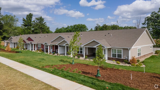
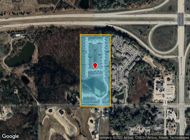
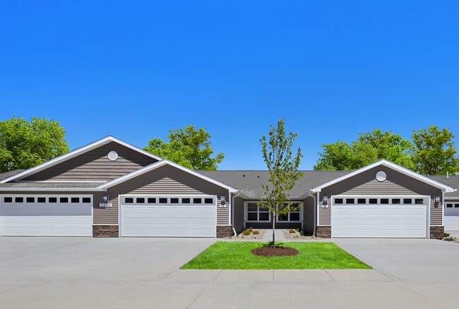
1315 W Clarion Rd
050-016-400-020-00
N 1/2 OF SE 1/4 OF SE 1/4 SEC 16 T5NR2W EXC E 90 FT FOR US 27 HWY R/W ALSO EXCBEG 1666.2 FT N OF SE COR SD SEC TH W 1311.9 FT
Multifamilydwelling
Clinton
X
Michigan
26065C0025D
16.94 AC
0
Outer Clinton County
2025
West Michigan
010107
Lansing-East Lansing, MI
5,180 SF
DEMOGRAPHICS near 1315 W Clarion Rd
1 mile
3 mile
5 mile
2024 Total Population
3,507
20,029
61,433
2029 Population
3,638
20,560
62,095
Pop Growth 2024-2029
+ 3.74%
+ 2.65%
+ 1.08%
Average Age
41
41
39
2024 Total Households
1,343
7,931
25,741
HH Growth 2024-2029
+ 3.72%
+ 2.65%
+ 0.97%
Median Household Inc
$89,123
$81,812
$61,619
Avg Household Size
2.50
2.50
2.30
2024 Avg HH Vehicles
2.00
2.00
2.00
Median Home Value
$277,083
$253,615
$187,336
Median Year Built
1993
1986
1973
Nearby Places
Map Layers
Map Styles
 Street
 Aerial
Transit
 Traffic
 Biking
Places
Listings with unknown addresses are not visible on the map
- Restaurants
- Banks
- Shops
- Fitness
- Groceries
PUBLIC TRANSPORTATION
COMMUTER RAIL
East Lansing Amtrak Station (Blue Water - Amtrak)
Drive
Walk
Distance
East Lansing Amtrak Station (Blue Water - Amtrak)
15 min
9.4 mi
AIRPORT
Capital Region International
Drive
Walk
Distance
Capital Region International
14 min
6.6 mi
Freight Ports
Port of Toledo
Drive
Walk
Distance
Port of Toledo
153 min
120.6 mi
Nearby Properties
Address
Land Use
TOTAL SIZE
Lot Size
Zoning
Address
Land Use
TOTAL SIZE
Lot Size
Zoning
142,152 SF
47.56 AC
B4
Address
Land Use
TOTAL SIZE
Lot Size
Zoning
4,312 SF
30.47 AC
M3
Address
Land Use
TOTAL SIZE
Lot Size
Zoning
3,252 SF
10.16 AC
M3
Address
Land Use
TOTAL SIZE
Lot Size
Zoning
2,092 SF
152.25 AC
MHP
Address
Land Use
TOTAL SIZE
Lot Size
Zoning
4,976 SF
6.23 AC
MF-N
Address
Land Use
TOTAL SIZE
Lot Size
Zoning
8,270 SF
13.15 AC
M3
Address
Land Use
TOTAL SIZE
Lot Size
Zoning
20,000 SF
25.53 AC
BC
Address
Land Use
TOTAL SIZE
Lot Size
Zoning
16,600 SF
19.22 AC
IL
Address
Land Use
TOTAL SIZE
Lot Size
Zoning
14,276 SF
6.42 AC
M3
Address
Land Use
TOTAL SIZE
Lot Size
Zoning
207,565 SF
11.50 AC
BC
Address
Land Use
TOTAL SIZE
Lot Size
Zoning
10,992 SF
10.43 AC
M3
Address
Land Use
TOTAL SIZE
Lot Size
Zoning
56,579 SF
8.48 AC
BSC
Address
Land Use
TOTAL SIZE
Lot Size
Zoning
4,464 SF
8.29 AC
MF
Address
Land Use
TOTAL SIZE
Lot Size
Zoning
86,211 SF
32.56 AC
BC
Address
Land Use
TOTAL SIZE
Lot Size
Zoning
39,372 SF
5.86 AC
BSC
Address
Land Use
TOTAL SIZE
Lot Size
Zoning
1,336 SF
2.92 AC
MF
Address
Land Use
TOTAL SIZE
Lot Size
Zoning
1,484 SF
34.71 AC
MHP
Address
Land Use
TOTAL SIZE
Lot Size
Zoning
19,000 SF
CB
Address
Land Use
TOTAL SIZE
Lot Size
Zoning
49,500 SF
4.38 AC
IL
Address
Land Use
TOTAL SIZE
Lot Size
Zoning
1,344 SF
2.43 AC
MF
Address
Land Use
TOTAL SIZE
Lot Size
Zoning
40.83 AC
IL
Address
Land Use
TOTAL SIZE
Lot Size
Zoning
8,247 SF
3.75 AC
BC
Address
Land Use
TOTAL SIZE
Lot Size
Zoning
26,110 SF
6.73 AC
OP
Address
Land Use
TOTAL SIZE
Lot Size
Zoning
15,000 SF
44.67 AC
A/BC
Address
Land Use
TOTAL SIZE
Lot Size
Zoning
1,868 SF
13.80 AC
MHP
Address
Land Use
TOTAL SIZE
Lot Size
Zoning
1,000 SF
236.70 AC
A
Address
Land Use
TOTAL SIZE
Lot Size
Zoning
15,576 SF
5.75 AC
M3
Address
Land Use
TOTAL SIZE
Lot Size
Zoning
2,342 SF
80 AC
A
Address
Land Use
TOTAL SIZE
Lot Size
Zoning
17,490 SF
3.48 AC
BC
The World's #1 Commercial Real Estate Marketplace
Connect with us
© 2026 CoStar Group
The information above has been obtained from sources believed reliable. While we do not doubt its accuracy we have not verified it and make no guarantee, warranty or representation about it. It is your responsibility to independently confirm its accuracy and completeness. Any projections, opinions, assumptions, or estimates used are for example only and do not represent the current or future performance of the property. The value of this transaction to you depends on tax and other factors which should be evaluated by your tax, financial, and legal advisors. You and your advisors should conduct a careful, independent investigation of the property to determine to your satisfaction the suitability of the property for your needs.