Property Record
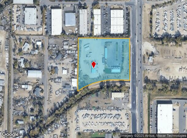
13159 Us Highway 85 N, Littleton, CO 80125
NEARBY LISTINGS FOR SALE OR LEASE
Property Detail
13159 Us Highway 85 N
Denver-Aurora-Lakewood, CO
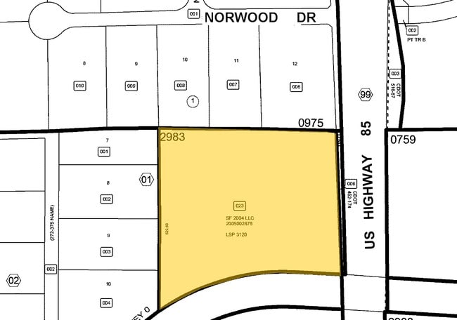
Metes And Bounds
2229-060-00-023
PART SE1/4 6-6-68 5.01 AM/L LSP 3120
Commercialnec
Douglas
X
Colorado
08059C0420F
23
2024
5.01 AC
2024
Outlying Douglas County
014131
Denver
4,212 SF
DEMOGRAPHICS near 13159 Us Highway 85 N
1 Mile
3 Mile
5 Mile
2024 Total Population
4,782
63,427
189,370
2029 Population
5,436
68,302
197,731
Pop Growth 2024-2029
+ 13.68%
+ 7.69%
+ 4.42%
Average Age
57
42
42
2024 Total Households
2,304
25,302
74,562
HH Growth 2024-2029
+ 13.63%
+ 7.98%
+ 4.27%
Median Household Inc
$100,189
$120,355
$115,665
Avg Household Size
1.90
2.40
2.50
2024 Avg HH Vehicles
2.00
2.00
2.00
Median Home Value
$705,491
$628,226
$630,000
Median Year Built
2005
1993
1988
Nearby Places
Map Layers
Map Styles
 Street
 Aerial
- Restaurants
- Banks
- Shops
- Fitness
- Groceries
PUBLIC TRANSPORTATION
AIRPORT
Denver International
DRIVE
WALK
Distance
Denver International
49 min
43.3 mi
Freight Ports
Tulsa Port Of Catoosa
DRIVE
WALK
Distance
Tulsa Port Of Catoosa
741 min
723.2 mi
Nearby Properties
Address
Land Use
TOTAL SIZE
Lot Size
Zoning
Address
Land Use
TOTAL SIZE
Lot Size
Zoning
571,212 SF
21.49 AC
Address
Land Use
TOTAL SIZE
Lot Size
Zoning
187,769 SF
16.09 AC
Address
Land Use
TOTAL SIZE
Lot Size
Zoning
622,103 SF
24.61 AC
PDU
Address
Land Use
TOTAL SIZE
Lot Size
Zoning
345,126 SF
21.94 AC
Address
Land Use
TOTAL SIZE
Lot Size
Zoning
206,000 SF
70 AC
PDU
Address
Land Use
TOTAL SIZE
Lot Size
Zoning
133,908 SF
9.39 AC
LPD-C
Address
Land Use
TOTAL SIZE
Lot Size
Zoning
215,900 SF
15.32 AC
PDU
Address
Land Use
TOTAL SIZE
Lot Size
Zoning
1,639,172 SF
53.02 AC
Address
Land Use
TOTAL SIZE
Lot Size
Zoning
150,767 SF
14.49 AC
PDU
Address
Land Use
TOTAL SIZE
Lot Size
Zoning
177,772 SF
16 AC
Address
Land Use
TOTAL SIZE
Lot Size
Zoning
519,330 SF
22.81 AC
PDU
Address
Land Use
TOTAL SIZE
Lot Size
Zoning
484,245 SF
18.06 AC
Address
Land Use
TOTAL SIZE
Lot Size
Zoning
411,924 SF
26.85 AC
LPDI
Address
Land Use
TOTAL SIZE
Lot Size
Zoning
192,108 SF
20.03 AC
Address
Land Use
TOTAL SIZE
Lot Size
Zoning
147,856 SF
5.49 AC
PDU
Address
Land Use
TOTAL SIZE
Lot Size
Zoning
312,130 SF
20.63 AC
PDU
Address
Land Use
TOTAL SIZE
Lot Size
Zoning
290,636 SF
14.54 AC
PDU
Address
Land Use
TOTAL SIZE
Lot Size
Zoning
1,036,325 SF
51.26 AC
PDU
Address
Land Use
TOTAL SIZE
Lot Size
Zoning
179,081 SF
6.79 AC
Address
Land Use
TOTAL SIZE
Lot Size
Zoning
65,260 SF
11.15 AC
Address
Land Use
TOTAL SIZE
Lot Size
Zoning
61,607 SF
11.60 AC
LPD-C
Address
Land Use
TOTAL SIZE
Lot Size
Zoning
112,847 SF
8.08 AC
PDU
Address
Land Use
TOTAL SIZE
Lot Size
Zoning
331,736 SF
Address
Land Use
TOTAL SIZE
Lot Size
Zoning
132,152 SF
7.51 AC
PDU
Address
Land Use
TOTAL SIZE
Lot Size
Zoning
351,792 SF
16.99 AC
LPD-C
Address
Land Use
TOTAL SIZE
Lot Size
Zoning
248,058 SF
12.24 AC
Address
Land Use
TOTAL SIZE
Lot Size
Zoning
282,692 SF
13.01 AC
Address
Land Use
TOTAL SIZE
Lot Size
Zoning
150,400 SF
6.65 AC
Address
Land Use
TOTAL SIZE
Lot Size
Zoning
251,979 SF
14.31 AC
Address
Land Use
TOTAL SIZE
Lot Size
Zoning
279,023 SF
13.15 AC
LPD-R
The World's #1 Commercial Real Estate Marketplace
Connect with us
© 2025 CoStar Group
The information above has been obtained from sources believed reliable. While we do not doubt its accuracy we have not verified it and make no guarantee, warranty or representation about it. It is your responsibility to independently confirm its accuracy and completeness. Any projections, opinions, assumptions, or estimates used are for example only and do not represent the current or future performance of the property. The value of this transaction to you depends on tax and other factors which should be evaluated by your tax, financial, and legal advisors. You and your advisors should conduct a careful, independent investigation of the property to determine to your satisfaction the suitability of the property for your needs.