Property Record
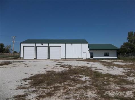
1317 E 470Th Rd, Bolivar, MO 65613


Property Detail
1317 E 470Th Rd
8910041900000001600
1.51 AC NEAR SW CRN SW SW E OF HWY
Commercialnec
Polk
B and X Area of moderate flood hazard, usually the area between the limits of the 100-year and 500-year floods.
Missouri
2024
1.51 AC
2024
Polk County
960302
Springfield
7,801 SF
Springfield, MO
NEARBY LISTINGS FOR SALE OR LEASE
-
-
View all Bolivar listings for sale on LoopNet.com
DEMOGRAPHICS near 1317 E 470Th Rd
1 mile
3 mile
5 mile
2024 Total Population
406
6,883
14,973
2029 Population
425
7,122
15,451
Pop Growth 2024-2029
+ 4.68%
+ 3.47%
+ 3.19%
Average Age
39
37
39
2024 Total Households
160
2,598
5,769
HH Growth 2024-2029
+ 4.38%
+ 3.66%
+ 3.29%
Median Household Inc
$57,272
$51,567
$52,331
Avg Household Size
2.40
2.40
2.40
2024 Avg HH Vehicles
2.00
2.00
2.00
Median Home Value
$253,333
$240,298
$219,329
Median Year Built
1994
1987
1984
Nearby Places
Map Layers
Map Styles
 Street
 Aerial
Transit
 Traffic
 Biking
Places
Listings with unknown addresses are not visible on the map
- Restaurants
- Banks
- Shops
- Fitness
- Groceries
PUBLIC TRANSPORTATION
AIRPORT
Springfield-Branson Ntl
Drive
Walk
Distance
Springfield-Branson Ntl
45 min
31.4 mi
Freight Ports
Tulsa Port of Inola
Drive
Walk
Distance
Tulsa Port of Inola
219 min
193.8 mi
Nearby Properties
Address
Land Use
TOTAL SIZE
Lot Size
Zoning
Address
Land Use
TOTAL SIZE
Lot Size
Zoning
51,549 SF
11.02 AC
Address
Land Use
TOTAL SIZE
Lot Size
Zoning
768 SF
10.88 AC
Address
Land Use
TOTAL SIZE
Lot Size
Zoning
7,796 SF
10.88 AC
Address
Land Use
TOTAL SIZE
Lot Size
Zoning
14,216 SF
2.79 AC
Address
Land Use
TOTAL SIZE
Lot Size
Zoning
67,200 SF
19.64 AC
Address
Land Use
TOTAL SIZE
Lot Size
Zoning
9,000 SF
4.44 AC
Address
Land Use
TOTAL SIZE
Lot Size
Zoning
101,850 SF
7.38 AC
Address
Land Use
TOTAL SIZE
Lot Size
Zoning
20,233 SF
2.10 AC
Address
Land Use
TOTAL SIZE
Lot Size
Zoning
10,848 SF
1.77 AC
Address
Land Use
TOTAL SIZE
Lot Size
Zoning
11,394 SF
14.21 AC
Address
Land Use
TOTAL SIZE
Lot Size
Zoning
7,523 SF
1.14 AC
Address
Land Use
TOTAL SIZE
Lot Size
Zoning
12,380 SF
1.86 AC
Address
Land Use
TOTAL SIZE
Lot Size
Zoning
6,893 SF
3.15 AC
Address
Land Use
TOTAL SIZE
Lot Size
Zoning
18,210 SF
1.86 AC
Address
Land Use
TOTAL SIZE
Lot Size
Zoning
8,045 SF
1.54 AC
Address
Land Use
TOTAL SIZE
Lot Size
Zoning
800 SF
4.41 AC
Address
Land Use
TOTAL SIZE
Lot Size
Zoning
2,400 SF
2.26 AC
Address
Land Use
TOTAL SIZE
Lot Size
Zoning
23,100 SF
2.86 AC
Address
Land Use
TOTAL SIZE
Lot Size
Zoning
13,628 SF
1.68 AC
Address
Land Use
TOTAL SIZE
Lot Size
Zoning
4,923 SF
1.50 AC
Address
Land Use
TOTAL SIZE
Lot Size
Zoning
11,880 SF
3.14 AC
Address
Land Use
TOTAL SIZE
Lot Size
Zoning
1,480 SF
4 AC
Address
Land Use
TOTAL SIZE
Lot Size
Zoning
1,463 SF
0.96 AC
Address
Land Use
TOTAL SIZE
Lot Size
Zoning
9,073 SF
7 AC
Address
Land Use
TOTAL SIZE
Lot Size
Zoning
1,995 SF
0.70 AC
Address
Land Use
TOTAL SIZE
Lot Size
Zoning
2,016 SF
0.89 AC
Address
Land Use
TOTAL SIZE
Lot Size
Zoning
12,665 SF
1.20 AC
Address
Land Use
TOTAL SIZE
Lot Size
Zoning
3,072 SF
0.10 AC
The World's #1 Commercial Real Estate Marketplace
Connect with us
© 2026 CoStar Group
The information above has been obtained from sources believed reliable. While we do not doubt its accuracy we have not verified it and make no guarantee, warranty or representation about it. It is your responsibility to independently confirm its accuracy and completeness. Any projections, opinions, assumptions, or estimates used are for example only and do not represent the current or future performance of the property. The value of this transaction to you depends on tax and other factors which should be evaluated by your tax, financial, and legal advisors. You and your advisors should conduct a careful, independent investigation of the property to determine to your satisfaction the suitability of the property for your needs.