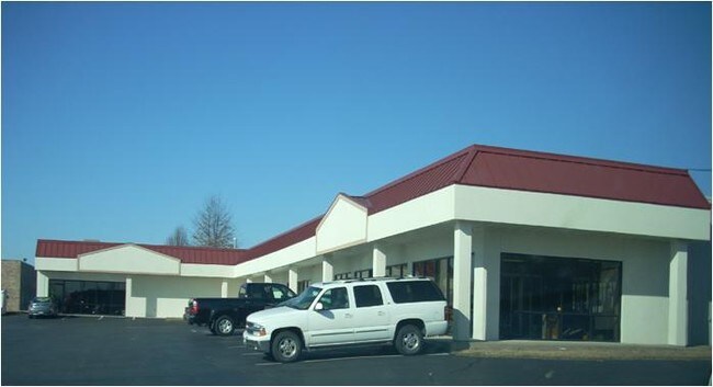
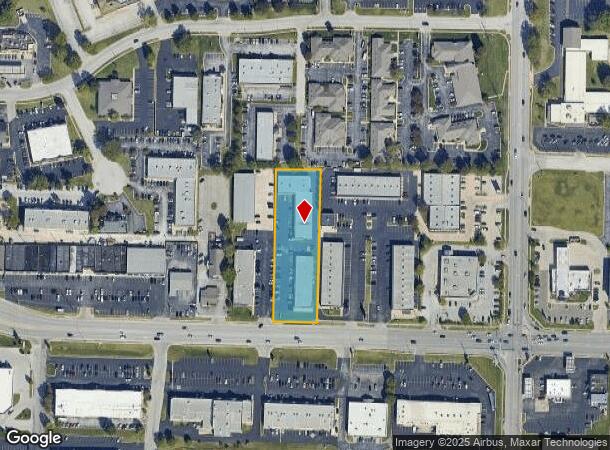
Property Record
1317 E Republic Rd, Springfield, MO 65804
Property Detail
1317 E Republic Rd
19-07-301-069
1.49A M/L E1/2 OF W 293.5 FT S 10A E1/2 SW1/4 7/28/21 (EX S 50 FT FOR STPURPOSES)
Commercialnec
Greene
X
Missouri
29077C0344E
1.49 AC
2025
Medical Mile
2025
Springfield
004005
Springfield, MO
19,550 SF
NEARBY LISTINGS FOR SALE OR LEASE
DEMOGRAPHICS near 1317 E Republic Rd
1 mile
3 mile
5 mile
2024 Total Population
6,838
61,574
156,871
2029 Population
7,034
63,514
163,133
Pop Growth 2024-2029
+ 2.87%
+ 3.15%
+ 3.99%
Average Age
46
42
40
2024 Total Households
3,431
28,721
70,611
HH Growth 2024-2029
+ 3.00%
+ 3.34%
+ 4.21%
Median Household Inc
$52,239
$55,114
$53,005
Avg Household Size
1.90
2.10
2.10
2024 Avg HH Vehicles
1.00
2.00
2.00
Median Home Value
$205,986
$196,827
$197,190
Median Year Built
1984
1983
1983
Nearby Places
Map Layers
Map Styles
 Street
 Aerial
Transit
 Traffic
 Biking
Places
Listings with unknown addresses are not visible on the map
- Restaurants
- Banks
- Shops
- Fitness
- Groceries
PUBLIC TRANSPORTATION
AIRPORT
Springfield-Branson Ntl
Drive
Walk
Distance
Springfield-Branson Ntl
31 min
16.1 mi
Freight Ports
Tulsa Port of Inola
Drive
Walk
Distance
Tulsa Port of Inola
193 min
173.6 mi
SALE & LEASE HISTORY
LISTING DATE
SALE/LEASE

Sep 25, 2016
For Lease
Nearby Properties
Address
Land Use
TOTAL SIZE
Lot Size
Zoning
Address
Land Use
TOTAL SIZE
Lot Size
Zoning
2,981,315 SF
76.43 AC
INC
Address
Land Use
TOTAL SIZE
Lot Size
Zoning
18.52 AC
INC
Address
Land Use
TOTAL SIZE
Lot Size
Zoning
15.46 AC
Address
Land Use
TOTAL SIZE
Lot Size
Zoning
299,725 SF
18.80 AC
INC
Address
Land Use
TOTAL SIZE
Lot Size
Zoning
284,904 SF
24.38 AC
INC
Address
Land Use
TOTAL SIZE
Lot Size
Zoning
376,072 SF
17.67 AC
INC
Address
Land Use
TOTAL SIZE
Lot Size
Zoning
12.74 AC
Address
Land Use
TOTAL SIZE
Lot Size
Zoning
210,374 SF
24.37 AC
INC
Address
Land Use
TOTAL SIZE
Lot Size
Zoning
180,665 SF
6.36 AC
INC
Address
Land Use
TOTAL SIZE
Lot Size
Zoning
15.46 AC
INC.
Address
Land Use
TOTAL SIZE
Lot Size
Zoning
1.98 AC
INC.
Address
Land Use
TOTAL SIZE
Lot Size
Zoning
105,278 SF
0.54 AC
INC
Address
Land Use
TOTAL SIZE
Lot Size
Zoning
2.31 AC
INC
Address
Land Use
TOTAL SIZE
Lot Size
Zoning
108,880 SF
3.62 AC
INC
Address
Land Use
TOTAL SIZE
Lot Size
Zoning
312,092 SF
38 AC
INC
Address
Land Use
TOTAL SIZE
Lot Size
Zoning
2.76 AC
INC.
Address
Land Use
TOTAL SIZE
Lot Size
Zoning
26.03 AC
INC
Address
Land Use
TOTAL SIZE
Lot Size
Zoning
51.65 AC
INC
Address
Land Use
TOTAL SIZE
Lot Size
Zoning
211,041 SF
19.13 AC
INC
Address
Land Use
TOTAL SIZE
Lot Size
Zoning
11.56 AC
INC
Address
Land Use
TOTAL SIZE
Lot Size
Zoning
3.43 AC
INC
Address
Land Use
TOTAL SIZE
Lot Size
Zoning
9.82 AC
INC
Address
Land Use
TOTAL SIZE
Lot Size
Zoning
1.99 AC
INC
Address
Land Use
TOTAL SIZE
Lot Size
Zoning
8.24 AC
INC
Address
Land Use
TOTAL SIZE
Lot Size
Zoning
140,147 SF
17.64 AC
INC
Address
Land Use
TOTAL SIZE
Lot Size
Zoning
42,540 SF
3.63 AC
INC
Address
Land Use
TOTAL SIZE
Lot Size
Zoning
30,400 SF
9.05 AC
INC
Address
Land Use
TOTAL SIZE
Lot Size
Zoning
12.90 AC
INC
Address
Land Use
TOTAL SIZE
Lot Size
Zoning
6.50 AC
INC.
Address
Land Use
TOTAL SIZE
Lot Size
Zoning
70,500 SF
7.20 AC
INC
The World's #1 Commercial Real Estate Marketplace
Connect with us
© 2026 CoStar Group
The information above has been obtained from sources believed reliable. While we do not doubt its accuracy we have not verified it and make no guarantee, warranty or representation about it. It is your responsibility to independently confirm its accuracy and completeness. Any projections, opinions, assumptions, or estimates used are for example only and do not represent the current or future performance of the property. The value of this transaction to you depends on tax and other factors which should be evaluated by your tax, financial, and legal advisors. You and your advisors should conduct a careful, independent investigation of the property to determine to your satisfaction the suitability of the property for your needs.