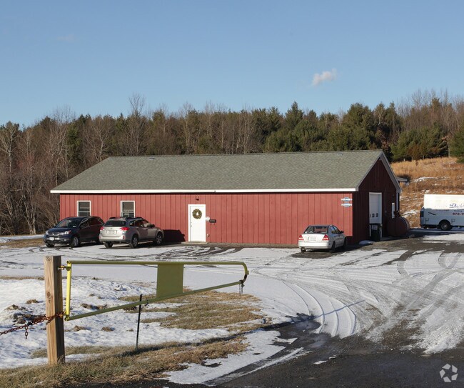
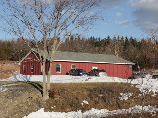
Property Record
1317 State Highway 217, Ghent, NY 12075

NEARBY LISTINGS FOR SALE OR LEASE
-
-
View all Ghent listings for sale on LoopNet.com
Property Detail
1317 State Highway 217
Hudson, NY
Columbia
103889-103-000-0001-043-120-0000
New York
Storesoffices
43.120
2025
2 AC
2024
Columbia County
000700
Albany/Schenectady/Troy
7,096 SF
DEMOGRAPHICS near 1317 State Highway 217
1 Mile
3 Mile
5 Mile
2024 Total Population
209
2,459
5,491
2029 Population
200
2,380
5,342
Pop Growth 2024-2029
(4.31%)
(3.21%)
(2.71%)
Average Age
46
44
46
2024 Total Households
87
1,008
2,291
HH Growth 2024-2029
(4.60%)
(3.37%)
(2.79%)
Median Household Inc
$64,375
$58,579
$65,748
Avg Household Size
2.30
2.30
2.30
2024 Avg HH Vehicles
2.00
2.00
2.00
Median Home Value
$251,923
$223,648
$264,218
Median Year Built
1963
1956
1966
Nearby Places
- Restaurants
- Banks
- Shops
- Fitness
- Groceries
Nearby Properties
Address
Land Use
TOTAL SIZE
Lot Size
Zoning
Address
Land Use
TOTAL SIZE
Lot Size
Zoning
27,408 SF
161.02 AC
HM
Address
Land Use
TOTAL SIZE
Lot Size
Zoning
Address
Land Use
TOTAL SIZE
Lot Size
Zoning
Address
Land Use
TOTAL SIZE
Lot Size
Zoning
46,870 SF
37 AC
07 - MIXED
Address
Land Use
TOTAL SIZE
Lot Size
Zoning
54,688 SF
18.76 AC
07 - MIXED
Address
Land Use
TOTAL SIZE
Lot Size
Zoning
7,009 SF
269.50 AC
RU C
Address
Land Use
TOTAL SIZE
Lot Size
Zoning
1,911 SF
188.02 AC
RA1 C
Address
Land Use
TOTAL SIZE
Lot Size
Zoning
Address
Land Use
TOTAL SIZE
Lot Size
Zoning
Address
Land Use
TOTAL SIZE
Lot Size
Zoning
28,248 SF
2 AC
07 - MIXED
Address
Land Use
TOTAL SIZE
Lot Size
Zoning
4,960 SF
50 AC
RA1 C
Address
Land Use
TOTAL SIZE
Lot Size
Zoning
8,818 SF
11.90 AC
HM
Address
Land Use
TOTAL SIZE
Lot Size
Zoning
2,714 SF
139.50 AC
RA1 C
Address
Land Use
TOTAL SIZE
Lot Size
Zoning
4,500 SF
24.27 AC
RU C
Address
Land Use
TOTAL SIZE
Lot Size
Zoning
3,041 SF
67.70 AC
01 - NOT Z
Address
Land Use
TOTAL SIZE
Lot Size
Zoning
211.60 AC
07 - MIXED
Address
Land Use
TOTAL SIZE
Lot Size
Zoning
3,236 SF
128.57 AC
RA2
Address
Land Use
TOTAL SIZE
Lot Size
Zoning
2,400 SF
66.40 AC
07 - MIXED
Address
Land Use
TOTAL SIZE
Lot Size
Zoning
2,782 SF
66.40 AC
RU
Address
Land Use
TOTAL SIZE
Lot Size
Zoning
6,992 SF
1.90 AC
07 - MIXED
Address
Land Use
TOTAL SIZE
Lot Size
Zoning
112.90 AC
01 - NOT Z
Address
Land Use
TOTAL SIZE
Lot Size
Zoning
106.90 AC
01 - NOT Z
Address
Land Use
TOTAL SIZE
Lot Size
Zoning
2,160 SF
26.52 AC
RA 1
Address
Land Use
TOTAL SIZE
Lot Size
Zoning
20 AC
Address
Land Use
TOTAL SIZE
Lot Size
Zoning
98.40 AC
RA1 C
Address
Land Use
TOTAL SIZE
Lot Size
Zoning
3,769 SF
0.71 AC
01 - NOT Z
Address
Land Use
TOTAL SIZE
Lot Size
Zoning
3,140 SF
2 AC
RA1 C
Address
Land Use
TOTAL SIZE
Lot Size
Zoning
4,099 SF
5 AC
RA2 C
Address
Land Use
TOTAL SIZE
Lot Size
Zoning
9,910 SF
1.06 AC
07 - MIXED
Address
Land Use
TOTAL SIZE
Lot Size
Zoning
41 AC
07 - MIXED
The World's #1 Commercial Real Estate Marketplace
Connect with us
© 2025 CoStar Group
The information above has been obtained from sources believed reliable. While we do not doubt its accuracy we have not verified it and make no guarantee, warranty or representation about it. It is your responsibility to independently confirm its accuracy and completeness. Any projections, opinions, assumptions, or estimates used are for example only and do not represent the current or future performance of the property. The value of this transaction to you depends on tax and other factors which should be evaluated by your tax, financial, and legal advisors. You and your advisors should conduct a careful, independent investigation of the property to determine to your satisfaction the suitability of the property for your needs.